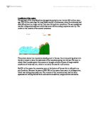
This picture shows two mountains standing next to the sea, the arrow pointing down into the sea is meant to show the sediments of the mountains going into the sea. The way, in which I feel I could explain this erosion is through millions of years of tough weather conditions of wind and rain, which is normally the case for rock erosion.
By 870 million years the mountains were at the bottom of the sea this is referred to as pre-Cambrian. Between the years of 830-790 million years there was a lot of deposition, which was taking place under sea. The remains of the mountains had, had the water squeezed out leaving behind hard rocks such as sandstone, conglomerates and shales.
This picture shows further eroding in the mountains and sandstone and other forms of rocks starting to develop at the bottom on the bottom of the sea.
Between 790-200 million years ago the land had rose and the sea level had droped dramatically, this had meant that the sediments that had eroded of the montains and deposited into the sea had formed dry land. This period of time when the area is all dried out is called the tectonic period , this leads to a lot of earthquakes of foldin and faulting. The mountains have now formed into two little stumps after a long period of eroding
This picture shows the mountains that have eroded even more to two little stumps, next to the dry land, which were made from the sediments of the mountains.
To the west of the west of the Wrekin the sedimentary couldn’t be bent anymore and broke this is now called the church stretton rift valley. The Wrekin has weathered down even more to two little faults, the rift valley dropped and the other was worn away.