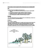
We discussed sampling methods and decided to use stratified sampling; using a transect. We chose this method because the Sand dunes are of different ages and we are looking at the changes from the youngest to the oldest. We sampled each dunes crest as it has the same environmental conditions at each crest. To compare each crest the conditions have to be similar, we studied ten points along a Transect.
We were put into groups to share the responsibilities of the field work and for safety reasons. Each group would take turns in measuring: soil samples, micro-climate (data logger), and vegetation. We studied safety precautions before we set off in our field work:
Health and safety:
- Go in groups – notify someone of when were and time of return.
- Wear appropriate clothing
- Weather forecast to help plan the day.
- Permission for safe access – no places of livestock, barbwire etc...
- Watch out for: uneven ground, rabbit holes, and spiny shrubs.
- Carry the ranging poles facing downwards to avoid accidents.
- Precaution: no eating during fieldwork, and wash hands on returning.
Data collection methods:
We took ten stops at each dune crest .Our equipment consisted of ranging poles a tape measure and an anbney level.
Our first hypothesis was established, when we got back to the lab.
-
Vegetation: our hypothesis “Range of species increase with distance inland” and “plant adaptations change inland”. Our equipment consisted of: a 10 point quadrat and a plant identification key. At each point we carried out a random sample along a Transect so it would be a standardised location. Each point in the quadrat represented 10%. If there is more than one plant species at each point each one was given 10%. The key described the characteristics of the plants so we could identify them accordingly.
-
Micro-climates: hypothesis “micro-climate changes inland”. We considered 4 aspects: 1-temperature 2-Light 3-Humidity 4-Windspeed. We used a data logger to measure Temperature (oC) Light (lux) and Humidity (%). I used an anemometer to measure wind speed in mph, we measured it at each dune crest and we took 3 readings to get the average.
I measured the temperature with the data logger at ground level, left it to settle for 2 minutes and took the reading in oC.
-
Soil: hypothesis “soil is modified by the accumulation of dead organic matter during succession”. We measured 3 aspects of the soil (organic content, moisture content, and the PH level).
We used a soil Auger to take a sample of soil we also used a spoon to spoon off the top 2.5 cm of the soil. I placed this in a bag. We were allowed dead leaves and dead organic matter to be in our sample but no live vegetation.
Moisture content:
We weighed the crucible, set the scales to 0 and then weighed 5g of fresh soil, placed the samples in an oven and let the samples dry overnight at 105oC, this evaporates moisture without affecting organic content.
The samples were re-weighed and % moisture content was calculated using this formula:
(Freshmass-Drymass)/Fresh mass x 100.
Organic content:
We took the same soil sample, burned off at 375oC so as not to affect the calcium carbonate. Soil sample was reweighed. The % organic content was calculated using the formula:
(Dry mass- Burned mass) /dry mass x 100.
Soil Ph:
We mixed 1 part fresh soil to 1 part distilled water (1:1); we removed any living plant matter and stirred with a spatula. The electrode sensors of the Ph meter was then rinsed in distilled water and placed in the mixture. I then recorded the reading when it was stable.