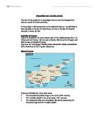
∙ The Troodos massif to the south (peak: 1951 metres).
∙ The Messaoria plain (not exceeding 180 metres) separating the Keryneia range and the Troodos massif.
Climate
Cyprus has mild wet winters (averaging 10-13oC), this contrasts to its hot dry summers (averaging 26-29oC).
Tourism
∙ 2.7 million tourists per year (Average).
∙ Average amount spent per tourist is £480 (GBP).
∙ £1.281 billion (GBP) revenue from tourism.
Cyprus’s tourism was largely founded in the 1960’s and it was continually successful and growing until the summer of 1974. The two most successful, highly developed regions of Cyprus, Famagusta and Kyrenia, were invaded and to this day remain in Turkish hands. The invasion near enough bought economic standstill for Cyprus and the tourist sector suffered the most. As a result of the invasion, Cyprus lost 72% (13,000 bed capacity) of the countries total bed capacity and 40% of the islands tourist facilities in restaurants, cafes, bars and nightclubs.
Despite this major setback to the countries tourist industry, the government, through the CTO (Cyprus Tourism Organisation) worked hard at re-establishing tourism. The work paid off, tourism was re-established.
By the early 1990’s, it became evident that the rapid developments of the 70’s and 80’s were taking its toll on the environment and the islands natural resources. Also, changes had taken place in international tourism and there was more competition. At this stage, on Butlers model, Cyprus was in Decline.
It was evident that the island had to be rejuvenated.
The CTO compiled and submitted a ‘Strategy for Tourism’. The target of this was to increase revenue to £1.94 billion (in 1998 prices) by the year 2010. To meet their target whilst ensuring the islands resources are not under too much strain, this target will be met through sustainable tourism.
In January 2001, the strategy was approved.
Certain aspects of the strategy are already being put in place, new products are being developed such as;
∙ Agro tourism.
∙ Athletic tourism.
∙ Nautical tourism.
∙ Cultural tourism.
Tourism, the revenue created by it, is of great importance to Cyprus. In 2000, total revenue reached £1.281 Billion (21% of the countries GDP). Also, 40.000 jobs are directly or indirectly related to tourism.
During the past years, the importance of tourism in the development of the countries economy has increased considerably. However, the prospect of keeping the same levels of tourist traffic depends on internal and external factors.
The main goals of the official tourist policy for the coming years are the improvement, enhancement and enrichment of the tourist product.