I questioned around 30 people around Shrivenham High Street. I approached a few more than 30 people but some were in a hurry or did not want to answer my questions. I used the same questionnaires as I did in Swindon. Although to prove or disprove hypothesis 2 all I needed to do was to work out the sphere of influence of Shrivenham so I only really needed the question of where people came from, although the others were interesting. I asked half the questions on Sunday night and the other half on Monday morning to get a better range of answers. I also asked the local newsagents how far they would deliver newspapers to and how far their customers came from. I found they deliver papers up to Longcot.
Using the same points on the High Street that I used for both the land use survey and the pedestrian counts (those points were chosen at equal distance throughout the High Street), I gave the area surrounding the point a mark or a scale for 0 to 3 using the criteria given. I used the same survey as that in Faringdon. Instructions and guidelines were given to help me mark the different points. The different criteria were building maintenance, road and pavement noise, litter, plants and traffic. There were a lot of determining factors such as the weather and my preconception of the area. Unlike Swindon, I did the whole street myself so there wasn’t a problem of differing views. The results I got when I prove or disprove hypothesis 3.
At each of the 5 points I stood for two minutes which was the same as in Swindon and counted the number of people who passed on both the right and left-hand side of the road. I recorded both the number of pedestrians and cars. Both children and babies were counted as pedestrians and cyclists as traffic. Because there weren’t many people it was easier to count than in Swindon, where I needed to use a tally. A limitation to this survey is the time of day as at peaks at school time and the rush hour in the morning. This survey is used to prove or disprove hypothesis 1.
In Swindon it was different as we were in groups and some counted one side while others counted the opposite side. It was obviously more hectic and mistakes made due to the amount of people. Also different groups did their surveys at different times of the day.
The last survey I did was the land use survey. I did it on the Monday morning. I started at the top of the High Street nearest Faringdon. I first mapped it out on rough paper to get an idea of the scale and amount of graph paper I would need. I kept it roughly to scale and I used the symbols given to remind me of the buildings when I came to write it up in neat. I used the same key as that in Swindon. The different buildings were put into categories, e.g. retail or finance. The function survey helped me with this. There are a few limitations; one is that the drawing is very inaccurate. I tried to get all the detail but I had to do it myself. Also some of the land in the High Street is subject to change and so since the data was collected in Swindon some might have changed although this is unlikely to cause major inaccuracies.
In Swindon it was even more inaccurate as there were more buildings to draw and you had to rely on other people’s judgement, which may have been different to mine. I used the same scale, 1cm for a normal shop frontage and 1cm for each storey. I used abbreviations for the different land uses, e.g. f-finance.
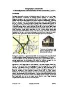
For my extra research I collected some census data from Abingdon library and I looked on the Internet for background information about Shrivenham. I also talked to some of the council members.