In a young river valley the main features found include:
- Narrow V-shaped valleys and Interlocking Spurs
- Rapids and Waterfalls
In an older river the main features found include:
- Meanders and ox-bow lakes
- Floodplains and Levees
- Deltas
As mentioned earlier, these features do not just appear, they are formed by different processes occurring at different stages of the river.
A) Features and Processes of Upland River Environments
(i) Narrow V-Shaped Valley and Interlocking Spurs
Description
In its youth the river valleys are steep-sided, narrow and shaped like the letter “V”. A young river is often forced to wind around protruding hillsides – these are called interlocking spurs.
Explanation
Near its source the river has lots of spare energy to transport large boulders and stones along the bed. This causes the river to cut down rapidly – a process called vertical erosion. When the young river has lots of energy it can also lengthen its channel by cutting backwards – a process known as headward erosion.
The valley sides are steep due to soil and loose rocks being washed downhill after heavy rainfall. This material is then added to the load of the river.
A diagram showing interlocking spurs
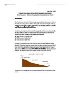
(ii) Rapids and Waterfalls
Description
A Waterfall is when a river meets a sudden interruption in the river bed and its course.
Explanation
Waterfalls form when a sudden drop is met in the course of a river. This drop may be a result of a drop in sea level, erosion by ice or earth movements. But usually a waterfall is formed when a river meets a layer of harder rock, then flows over a layer of softer rock. The softer rock underneath is eroded more quickly than the more resistant hard rock, resulting in an undercutting below the harder rock. Over time, as the undercutting increases, an overhang of hard rock is formed, and is subsequently collapses under the force of its own weight. Over time, the break-offs from this collapse will form a deep plunge pool. This is because of the rocks being swirled around (especially at times of high discharge) and colliding with the sides of the pool. These types of erosion are called hydraulic action and attrition. After these processes are repeated several times, a steep-sided gorge is formed as the waterfall retreats. Rapids occur where the layers of hard and soft rock are very thin, so no break in the slope occurs like in a water fall.
A diagram showing Rapids and Waterfalls
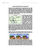
B) Features and Processes of Lowland River Environments
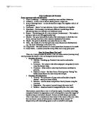
(i) Meanders and Ox-bow lakes
Description
A Meander is a bend in a river. The bend increases over time to form an ox-bow lake, which is shaped like a banana.
Explanation
When a river is nearing its mouth, it is flowing over much flatter, with less of a gradient. At this point in the rivers profile, large bends often form, known as meanders. These meanders form when a piece of hard rock lies on the bank on one side of a straight river. As the water flows past the hard rock, the soft rock past it is eroded. This directs the flow toward the outside of the river, causing lateral erosion on one side of the river, causing a slight bend in the path. This slight bend is exaggerated as the water is thrown to the outside of the bend due to the centrifugal acting upon the water. So as the river approaches the meander, the flow is directed toward the outside of the bend, causing erosion on one side of the meander. This causes a reduction in friction, increasing the velocity of the river at this point. This velocity enables the river to transport more material in suspension, and this material erodes in the form of corrasion against the bank. This causes an undercutting of the bank, causing it to collapse, and retreat backwards like a waterfall would. This undercutting is called a river cliff’.
During this increase in velocity on the outside of the bend, the velocity decreases on the inside of the bend. This is because there is less water on the inside because it has been thrown to the outside of the meander loop. Furthermore, the velocity decreases because the is more friction against the river bed and bank on the inside of the meander. Due to this loss in velocity and energy, the material in suspension (the rivers load) is deposited. This deposition builds up to form a slip-off slope.
As the erosion continues on the outside of the meander loop, the meander neck narrows until, often during flooding or high discharge, the necks join, meaning the river can flow a shorter course. The original meander will be left as a pool of water, known as an ox-bow lake. This lake will gradually dry up, unless there is heavy rainfall.
A diagram showing Meanders and Ox-bow lakes
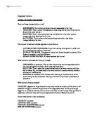
(ii) Floodplain and Levées
Description
A floodplain is an area of flat land surround a river. It is formed when the river floods. A levee is also formed when a river floods, and is a natural embankment on the upper banks of a river.
Explanation
A river is widened by the lateral erosion of the river. When there is high discharge, the high amounts of energy in the river can transport large amounts of material in suspension. In high discharge, the river often floods, spreading out across any nearby flat land. This land causes sudden increase in friction, and so velocity decreases causing much deposition of fine silt. Every time a river floods, another thin layer of silt is deposited, and a flat floodplain is formed. The heaviest material will be deposited first when a river floods, forming an embankment next to the river, called a levees. This levees acts as a natural flood defence, and are sometimes strengthened. If these levees are broken, then huge floods occur over great areas of land.
A diagram showing Floodplains and Levees
(iii) Deltas
Description
A delta is a small area of land formed from deposition when a strong current meets a weaker current.
Explanation
As a river gets closer to its mouth and the sea, the current is dramatically reduced, and its material deposited. This deposited material can block the rivers path. The river must then divide into a series of channels, called distributaries, in order to reach the sea. Over time, the deposited material builds up to form a delta. These are only formed when the amount of material brought down is too much for the sea currents to remove. A delta can also form when a river flows into the gentle, slow current of a lake.
A diagram showing Deltas
Conclusion
As mentioned earlier, a river has a variety of features along its length depending on:
- The energy that a river has to erode and transport its material – a river will have more energy near its source when it is young and fast-flowing.
- the gradient of a river – the steeper the gradient, the faster the river flows and the more energy it has to erode and transport
- the shape of the river valley and valley sides – the steeper and deeper the valley the faster the river will flow unless the water is too turbulent to flow forwards
Other factors affect the shape of a river and the valley sides including:
Weathering
This is when wind, rain and temperature changes act upon the valley sides. The effect of weathering is to break up the rock or soil on the valley sides which then falls into the river. This “extra” material is then used by the river in abrasion or adds to the “load” of the river.
Two important types of physical weathering include:
Freeze-thaw occurs when water within cracks in a rock freezes and expands and then warms up and melts. Over time this can break up the rock into scree, which under the influence of gravity rolls down the valley sides into the river. This process would affect Britain in the winter months.
Exfoliation or “onion” weathering
This occurs when a rock heats up in the sunshine and then cools down at night. Over time the rock splits into layers and breaks up and rolls into the river. This process occurs in Britain during the summer months.
If weathering continues valley sides will be worn down and more load will be added to the river.
Human action
This can affect rivers in many ways. Humans can alter the shape and course of a river by straightening the channel, building artificial banks, dredging the channel and building bridges, viaducts and locks. Humans also erode the sides of rivers by farming too close to the river’s edge and walking along paths which follow a river. Humans can also pollute a river by dumping waste and chemicals into the water, killing fish and vegetation.
Ends