"Glaciated Uplands are landscapes of erosion: glaciated lowlands are landscapes of deposition" examine the validity of this statement with reference to glaciated areas you have studied
"Glaciated Uplands are landscapes of erosion: glaciated lowlands are landscapes of deposition" examine the validity of this statement with reference to glaciated areas you have studied Arran is an ideal place to look at when examining the validity of the statement. During the Devensian Glacial, the ice sheet covering Britain reached its furthest extent, totally covering Arran. This helped to shape the landscape. In around 11,000BP the Loch Lomond Readvance occurred. This time Arran was not covered by an ice sheet but its valley glaciers grew. This formed many of the features still clearly seen on the island today. They show fresh and visible signs of the glacial erosion and deposition that once occurred. Glacial erosion is caused by ice movement combined with material within it. One type of erosion is abrasion. This occurs when pieces of rock held within the ice rub against other pieces of rock wearing them down. Another type of erosion is plucking. This occurs when ice freezes onto a piece of rock on the valley side. When the glacier moves away it may then be broken off. For these processes to occur it helps to have a steep gradient, as this will lead to ice flow. A harsh climate is also needed, which is cold, to encourage ice formation and accumulation. These conditions are often found in upland areas. Glacial deposition is caused by melting when material is dumped in

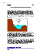
How does the Efficiency and Cross-Sectional Area of a River Change Down Stream?
How does the Efficiency and Cross-Sectional Area of a River Change Down Stream? For my investigation I will be looking at the cross-sectional area of a river and how this affects efficiency in the river of Little Beck as the stream moves downstream from the source to nearer the mouth. To do this I will be taking measurements of the cross sectional area and the efficiency at 12 different sites along the river (See fig. 2 for map of river and 12 sites). The source of May Beck is approximately at a height of 280m on Fylingdales Moor in the North Yorkshire Moor National Park. The river flows south to join the Parsley beck, and the combined flow of these two rivers, now called the Little Beck, becomes tributary of the much larger river, River Esk, which reaches the sea at Whitby. During my investigation, I will be comparing my results to that of the Bradshaw Model. The Bradshaw Model is a model of an ideal stream (see fig. 1). By using this I can compare my results with the model to see how ideal Little Beck is. According to the Bradshaw model, at the source of the stream the cross-sectional area and efficiency are low at the source but as you move down stream they increase. Three key questions I have constructed to help me with my investigation are: . How does efficiency change as you go down stream compared to the predictions of the Bradshaw Model? 2. How does
An Investigation of Channel and Stream Characteristics For Streams on the Isle of Arran
An Investigation of Channel and Stream Characteristics For Streams on the Isle of Arran Aims To investigate hypothesis associated with increasing distance down stream for streams on the Isle of Arron. Objectives To set up and test hypothesis To investigate how channel characteristics change with increasing stream order. Hypothesis . As the river progresses downstream the bedload decreases in size. 2. The bedload becomes rounder in shape downsream. 3. The width will increase in size as the river goes downstream towards the mouth of the river. 4. The velocity of the river will decrease as it goes downstream. 5. The depth will increase in size as it goes downstream. 6. The discharge will also increase as it goes downstream. Theory There are three processes by which material is transported from land to the sea (via rivers) these are: i) Weathering-physical and chemical breakdown of rocks. ii) The slope-the products of wethering are moved down the gravity gradient in mass movements by the slope wash processes. iii) Fluid transfer-water, air and ice. The load, carried by natural streams, can be separated into three compounds. The material carried by the river is called the rivers load. It comes from river erosion and weathering of the river banks. Especially when the river is bankfull, considerable quantities of load can be carried. The total amount
Upper Porter Valley in Sheffield - source related study.
History Around Us By Philip Jacobs Introduction On Tuesday 10th June 2003 and Wednesday 18th June 2003 I visited the upper Porter Valley in Sheffield. The purpose of these visits was to give me an understanding and provide evidence to aid me in answering the following questions. a) Would your visit to Shepherd Wheel give you enough evidence to support what is said in Sources A, B and C? b) Consider all the sites you have visited to help you answer the following question b) i) How useful are the various sites in the Upper Porter Valley for learning about water powered sites and the cutlery industry before 1850? b) ii) Is there sufficient evidence in the valley to provide a good understanding of Porter Valley's water powered sites and cutlery making industry? a) Would your visit to Shepherd Wheel give you enough evidence to support what is said in Sources A, B and C? Source A - The heyday of the water mill in Sheffield was in the late 1700s when the streams were often so crowded that the tail goit of one mill fed the dam of the next. The Forge and the Wheel - J G Timmins Source A says that "the heyday of the water mill in Sheffield was in the late 1700s". At Shepherd Wheel there is little evidence to support this claim. Though a small, modern plaque outside the workshop says that a Mr. Shepherd employed 10 men to work for him in 1794. This can be seen in figure
Describe and explain the physical and human causes of flooding and the possible solutions that may be undertaken to prevent flooding and to deal with it.
Flooding Essay. Describe and explain the physical and human causes of flooding and the possible solutions that may be undertaken to prevent flooding and to deal with it. There are many factors that contribute to the causes of flooding. These causes can either be human, (things that happen due to human life and civilisation) or physical, (things that happen naturally to cause flooding). Physical causes: The drainage basin is the area of which the river drains its water from. The boundaries are marked by the watershed. There are many different ways of which water can enter the river channel. Some ways are quicker that others. The quickest are examples like surface run-off. This happens when the rate of precipitation exceeds the rate of infiltration, so it flows over the top of the surface and into the river. The slowest ways for water to travel are groundwater flow. Precipitation has to infiltrate through the soil then pass horizontally through permeable rock and into the river. These can increase the risk of flooding as the water is getting to the river quicker. This will cause a mass excess of water to run into the river and flood its banks. Groundwater flow will stop water getting to the river channel quicker but it will eventually get there. Also if storage of water is held somewhere this can increase the risk of flooding. For example surface storage occurs when the
How are Glaciers formed and what land forms do they form ?
How are Glaciers formed and what land forms do they form ? A glacier is formed as a result of an accumulation of snow over a long period of time. The snow puts pressure on the lower layers of snow, which then transform into ice. This is because the weight of the top layers of snow compact the snow so tight that an icy layer forms. This process keeps on going on and starts to expand down the valley. This is due to gravity and space. The Glacier will grow in a v-shaped valley which will then erode into a u-shaped valley. For glaciers to develop the temperature has to be always below 0°C. Glaciers are formed when there is an interruption in the hydrological cycle (water cycle). This happens when the rain drops freeze due to the very low temperatures (has to be below 0°C). The rain drops turn into snow and so the whole process begins. Once the glacier is formed and starts to grow down slope, the snout pushes debris and rocks (see erratics) with it. Eventually when the glacier has stopped growing and as it starts to retreat back up the valley, a ridge of dirt is left at the bottom of the valley. This is called terminal moraine. Recessional moraine is formed when the glacier has already retreated once and grown back down the valley, but not as far as the terminal moraine. Between these two which can act as a natural dam, a lake can be formed. As the glacier grows down slope
The History of the River Lee.
The History of the River Lee The River Lea or Lee runs from Luton in Bedfordshire to the River Thames in east London. Evidence of Bronze and Iron Age settlements have been found along the length of the river and the Romans built Ermine Street parallel to the Lee shortly after they arrived in Britain around two thousand years ago. During the 9th century the river formed part of the boundary between Saxon England to the west and the invading Vikings to the east, led by King Alfred the Great and Guthrum respectively. It is said that when the Danes sailed up the river in around 895AD and established a base near Ware, Alfred stranded them there by reducing the level of the river. He did this by building an embankment and weir near the Thames, and dividing the river just above Waltham Abbey. How true this is we do not know, but the remains of Viking ships have been found near Hertford and Stanstead Abbots, the river does split into three near Waltham Abbey and the names Kings Weir and Blackwall date back to these times. The waters of the Lee powered many mills producing flour, gunpowder and also England's first paper mill in c1494. As early as 1424 parliament passed an act allowing works to improve navigation, and the Lee was for centuries an important goods highway into London. Malt, flour, coal and gunpowder were all transported in large quantities to the capital. During the

Three Gorges Dam
Super Dams - Triumph or Disaster Introduction The 3 Gorges Dam is a project that will take around 15-20 years to complete. The project is situated on the Yangtze River in central china. The dam will be constructed over the 3 gorge section of the river Yangtze. When completed, it will be a towering 600 feet high and approximately 1.2 miles wide. It will require tens of thousands of workers to be the construction team of the largest dam at present. It is estimated to have a final cost of around £45 billion and will create a lake around 370 miles long. This diagram shows the location of the construction site of the three gorges dam. What environmental problems will does the Chinese government believe that the 3 gorges dam will solve? Over many years, the river Yangtze has been flooding across farmland and cities. This has ruined valuable land and takes a great deal of time to put back the way it was. In the 1996 floods, hundreds of people were killed and millions were forced to leave there homes. Roads, railways and power lines were all cut off. The water that had risen was more than a foot over the danger level. The water that flooded the land was infested with many water born diseases, this water became mixed with the drinking water for many people. All of these problems are aimed to be stopped by the building of the 3 gorges dam. The main problem that the 3 gorges dam

The difference between a straight section and a meandering section.
AIM This investigation is about river channels. We will be investigating the difference between a straight section and a meandering section. Choice of Site? The river we are studying is Millbrook, in the Ashdown forest just south of East Grinstead. The Ashdown Forrest is between 6 major roads, the A23, A272, A22, A275, A264 and the M23. This make Ashdown forest an incredibly accessible place. We decide to survey Millbrook for many reasons, the school we attend, Reigate Grammar School, is relatively close to the river, and other nearby rivers were not usable because of the foot and mouth crisis earlier in the year. Also the river had quality's which meant it would not be too hard to study. As we only had basic equipment, tape measure and metre rulers, if the river had been too deep or too wide we would have had a lot of trouble taking even these simple measurements. The river was also "manageable" by this I mean that the river was not too fast, if the river was too fast it could have been dangerous too stand in the river. Though these were all good reasons too study this river we wouldn't be able to unless we gained permission from the conservators, which we had. We also studied the river in September, as this is when most rivers are at there lowest. When we arrived at the river we soon realised that not every section of the river would be suitable to study. We
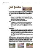
Soil Erosion.
Introduction: Soil erosion is a gradual process that occurs when the actions of water, wind, and other factors eat away and wear down the land, causing the soil to deteriorate or disappear completely. Soil deterioration and low quality of water due to erosion and run off has often become a severe problem around South Africa. Many times the problems become so severe that the land can no longer be cultivated and is abandoned. Problems: > The loss of topsoil reduces the country's soil fertility, hence the ability to grow food. More fertilizers will have to be used as a substitute for the lost soil, therefore a raise in food costs. > The hydrology of river systems is affected, as there is less infiltration and more runoff and therefore reducing the amount of water in the soil for new vegetation to use next season. Seeds struggle to germinate in bare exposed soil. > Dams become silted up and there storage capacity is reduced. > Floods become an increased hazard, because of the increased runoff. Causes: > Overgrazing causes the destruction of plant cover, which would otherwise protect the soil; therefore instead of the rain soaking through the soil, it washes it away. > Ploughing of soil vertically with a slope, increases runoff and accelerates soil erosion. > Destruction of forests is also a major cause, as well as footpaths used for domestic purposes, which turn into