Flooding in Bangladesh.
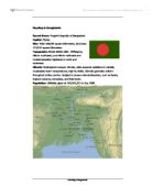
Formal Name: People's Republic of Bangladesh.
Capital: Dhaka.
Size: Total 144,000 square kilometres, land area 133,910 square kilometres.
Topography: Broad deltaic plain. Chittagong Hills in southeast, Low Hills in northeast and modest-elevation highlands in north and northwest.
Climate: Subtropical monsoon climate, wide seasonal variations in rainfall, moderately warm temperatures, high humidity. Climate generally uniform throughout entire country. Subject to severe natural disasters, such as floods, tropical cyclones, tornadoes, and tidal bores.
Population: Officially given at 109,963,551 in July 1988.
Bangladesh is trapped between two sets of floods: one caused by tidal surges and a rising sea level, and the other by rivers.