- The size, area, shape, slope, aspect and altitude of basins
- The local climate, geology, soil type, vegetation cover and anthropogenic influences on storage capacity, infiltration and transmissivity
- Drainage networks present
- Channel factors such as capacity
- Estuary shape
- Coastline configuration
- Offshore gradient of water depth
7. History of Flooding
In the 1980s there were at least 60 major flood disasters, each involving the loss of more than 100 lives. These occurred in 17 countries mostly in Asia and South America. A similar number occurred in the 1990s including the 1990 floods in Australia covering an area the size of western Europe. Further record breaking floods occurred throughout the 1990s including:
- 1993, Victoria, Australia – worst floods for 50 years
- 1991, China – worst floods for a century, more than 1400 people died
- 1996, China – heaviest rains in 50 years, more than 250 people killed
- 1991, Philippines – flash flooding, 2000/3000 people died
- 1992, Pakistan – flash flooding, 2000/3000 people died
- 1993, Japan – Tsunami initiated flooding, 300 people dead
- 1995, Rhine Countries – wettest January for nearly 50 years
The largest percentage of floods occur in Asia as seen from the table below [Source OFDA, 1996 in 1] showing the percentage of all recorded flood disasters and associated flood impacts from 1964-96 by continental area (excluding USA). However as figure 3 shows the problem of flooding is truly global in its nature.
Table 2: Percentage of Flood Disasters by Area. Source OFDA, 1996, [1]
8. Data Reliability
As the arguments for the increase of flooding are statistically and climate model based it is important than the most accurate reliable data possible is used. The best sources may be argued to be collected by some type of governmental organisation and concern hydrological data, social data (disaster occurrence) and global circulation models (GCMs).
8.1 Hydrological Data
Reliable and comprehensive hydrological data are still not universally collected and in some countries have not been collected until relatively recently. Where data on river flow and rainfall are collected they may be less than adequate for detailed flood studies. This is because non-continuous recording may miss flood peaks or periods of significant rainfall. The largest floods also are often not recorded as the flood actions can destroy the recorders and control sections involved [5].
8.2 Flood Disaster Data
The information on recorded flood disasters used in this report is largely taken from EM-DAT: The OFDA/CRED International Disaster Database [4]. This is an international source of disaster data, collected by the office of US foreign disaster assistance (OFDA) and can be considered accurate and reliable. In order for a disaster to be entered in to this database at least one of the following criteria has to be fulfilled:
- 10 or more people reported killed
- 100 people reported affected
- a call for international assistance
- declaration of a state of emergency
Consequently these figures may not reflect true flood frequency, only flood hazards.
8.3 Model Data
General circulation models (GCM) are extensions of existing weather forecasting models, operating on different time and spatial scales and have been used by numerous bodies including the IPPC in estimating changes in climate. The modelling with regards to rainfall is based on straightforward physical theory and can therefore expected to give reliable estimates and quantitative predictions over large areas [6]. Typical GCM models have a horizontal resolution of 300 to 1000km2 and the results from them become less reliable on smaller geographical scales [3]. The reliability of any estimate of impact of climate change on surface hydrology is subject to the limitations of the GCMs, but the values quoted are considered to be plausible changes in run-off based on the current state of science.
9. Current Trends
Studies considered in the Greenpeace report into flooding [3] indicate that runoff (the hydrological response of river basins to climate conditions) in most areas of the world has shown substantial increase. For example the alpine and non-alpine related runoff into German streams since 1965 has increased by 26%. Increases in natural streamflows (those unaffected by man) in the USA have been shown to have increased and in the Summer of 1993 the water level in the northern Mississippi basin was the highest on record with nearly 17,000 square miles of land covered by floodwaters, see figure 4.
However in Australia a different situation was discovered where drought and moisture indices showed no systematic long-term changes, however no trends in rainfall were investigated [3]. The increase in rainfall in temperate areas and a decrease in precipitation in more arid climates fits in with predicted global changes due to climate change as predicted by the IPPC GCM.
The data for recorded flood disasters throughout the world held by two reliable databases, the OFDA and RFF databases show increasing trends in flood disaster occurrence [1]. Graphs, independently calculated from the OFDA figures, show a trend towards an increase in the number of events over the last 40 years, see figures 5-7.
Combination of these two sets of data suggest the following:
- There has been an increase in the number of extreme precipitation events leading to flooding over the last forty years.
- There has also been an increase in flooding events over the last century that have directly affected man. Deaths and economic losses have increased.
However the data does not give evidence on whether the reasons for the increases are natural (i.e. natural climate change) or anthropogenic. The data
quoted does not go back further than the mid twentieth century so there is an argument that the increasing trend could be part of a larger ‘wave’ and that a decrease in flooding rates may occur. It is also hard to estimate the impact that technology has had and will have on these trends.
The current public and scientific consensus is that these trends are set to continue, unless understanding the underlying reasons, prevention and remediation, can counteract them.
10. Reasons for Trends
10.1 Urbanisation
Urban areas occupy less than 3% of the Earths land surface, but the effect of urbanisation on flood hydrology and flood hazard is disproportionately large. There is evidence that urban areas increase the number of flood incidents by altering climate and drainage and also increase flood hazard frequency due to construction in prone areas. The Environment Agency in the UK objects to 30,000 planning applications a year in areas prone to flooding but 20 per cent of these are approved, and are regarded as trivial by local planners. They still increase the area of building in the flood plain - and reduce the amount of storage capacity for water, which is therefore forced into the river unnaturally fast, flooding further downstream [8].
There is strong evidence that urban areas create their own climate, with more precipitation falling on the area than elsewhere. Flood conditions within and downstream of urban areas are often modified by changes in channel morphology which are engineered to improve efficiency and capacity or are naturally altered by erosion and sediment from the urbanised areas. The water levels downstream are also directly influenced by the import of clean water and export of dirty water through stormwater and sewerage systems.
Urban surfaces are less permeable than the natural surface they replace; this effectively means that runoff occurs faster and in higher volumes. Many urban storm water systems in countries such as the UK are old and can only cope with low magnitude events such as those having return periods of up to 25 years. Consequently widespread flooding frequently occurs in urban areas, especially as increased precipitation can occur in these areas and this trend is thought to be continuing [1]. However urban planning designs can remediate this with choice of surfacing material and design of storm water channels [9].
Subsurface flooding has increased in major urban areas that have complex underground transport and service systems now that industrial decline has resulted in reduced groundwater abstraction and rising groundwater levels. For example in central London the water table rose 36m between the 1970s and mid 1990s and is predicted to rise a further 20 –30 m by the year 2005 [10]. Subsurface flooding can be easily counteracted in these situations by increasing the rate of groundwater abstraction for public use or other purposes.
The rise in numbers of recorded flood disasters can also be contributed to social economic reasons. An increasing population in most countries of the world has an accompanying need for homes, food and employment. These can all be found along rivers, estuaries and coastlines and the urban development of areas prone to flood hazard is undeniable. In lesser developed countries flood defences are often absent or unsuitable leading to both economic and fatal disasters when floods occur.
In richer countries coastal zones are often seen as attractive areas for recreation and have high property prices due to their desirability. Flood plains are becoming more developed for lower cost housing as the demand for homes increases. Flood defences provide security and tend to encourage building but they are normally designed only for floods with return periods of 100 years or less [1]. This leads, normally, only to economic losses due to a lessening of the impact and, usually, good early warning systems operated by local authorities.
10.2 Forestry
Forestry is suggested to play a part in the modification of basin flood characteristics. Deforestation may intensify river flooding by adversely affecting soil structure and volume, reducing infiltration rates by the effects of diminished root mass and encouraging concrete rather than granular frost and reducing water storage. The effect of forestry is debatable as it is argued that these influences will only be significant during low magnitude frequent storms. The effect is thought to diminish as prolonged heavy rainfall and/or melting fills available storage and creates widespread conditions of surface saturation and zero infiltration. The effects will be also significant in areas such as swampland and steep slopes with shallow soils where there is always low storage.
The effects of forestry to increase flooding is argued to be strongest on the Indian sub-continent where deforestation is said to have caused higher surface runoff, consequential soil erosion and therefore reduced water storage capacity. However, the hydrological data for this area is inconclusive as to the evidence that flooding has increased in this area (the Ganges plain) and it is also counter-argued that the effects of the monsoon create little difference in saturation between forested and deforested areas.
The Dutch authorities investigated the causes of flooding of the Meuse in 1993 and concluded that landuse and infrastructure were the most important factors responsible for the increase in peak water levels and frequency of high runoff peaks. It was also concluded that the impact of forestry on an area was negligible as over the period 1834 – 1992 the forest area increased in size by 10% [9].
Short-term modification of river flood behaviour is agreed to occur due to the human activity associated with forestry such as ploughing and drainage, road construction and compaction of soils. Also, despite the debatable influence of deforestation, tree planting remains a suggested remediation technique of flood effects.
10.3 Agriculture and Land Maturity
Every alteration in the pattern of agricultural production can be shown to modify flood occurrence and the ploughing up of former extensive grasslands is said to have increased the flood potential of some river basins [9]. Removal of vegetation, or conversion to plants with lower evapotranspiration and interception, increases run-off volumes and lowers storage.
The character of flooding may have also have changed due to landscaping in developed countries. In early historical times rivers probably flooded frequently but as river basins and floodplains were primitive and poorly drained the floodwaters would have gradually risen, peaked and then drained without the sudden flash flood nature of today’s occurrences [9]. Modern land use changes and improved drainage speed up the entry of water into stream channels. This has then eroded deeper channels that can accommodate greater flows of water that would have otherwise caused minor flooding events. Now larger events overtop the stream channels causing rapid inundation resulting in that floodwaters cannot drain easily back into channels. Human alteration of the stream channel, for example by dams, dikes and bridges to control redirect or irrigate, also change the overall conveyance system of a catchment area.
A study by Boardman et al (1994) consulted by Greenpeace [3] found that in the last twenty years there has been an increase in the incidence of flooding of property by run-off from agricultural land in north-western Europe. The Royal Meteorological Office at Ukkel found evidence that both increases in precipitation intensity and changes in land use due to agricultural development were deciding factors.
10.4 Climate Change
10.4.1 Increased Precipitation
The earth is coming out of the last glacial period meaning that climate change, whether anthropogenically enhanced or not, is occurring. Changes in atmospheric circulation and the temperature difference between the sea surface and overlying atmosphere can cause local alterations in the frequency of intense or prolonged precipitation. This in turn leads to the increase in size and frequency of river flood events [5]. Records on recent flooding and paleoflooding indicate the high sensitivity of flood occurrence to changing climate for river basins in the USA and Europe [11]. Analyses also indicate no simple proportionality between the scale and frequency of floods and climate variations. However, in general, increases in precipitation lead to proportionately larger increases in runoff [3].
Models for future climate change suggest that an increase in CO2 may cause an increase in the intensity of the global hydrological cycle and therefore an associated increase in global mean precipitation. This increase varies in the literature from 3 to 11% increases for a doubling of atmospheric CO2 [9]. However it should be stressed that this is a mean and regional change will expect to vary widely from these figures. Increases in precipitation are particularly expected at high latitudes throughout the year and in mid-latitudes during winter. More rainfall is predicted in the monsoon regions of Southeast Asia, but the projections for the tropics are uncertain and vary form model to model [9]. In the southern hemisphere precipitation increases are predicted along the mid-latitude storm tracks.
Observations of regional trends in rainfall are consistent with the GCM predictions made by the IPPC and other official bodies. There is observational evidence for increased rainfall in Europe including a 5% increase measured from 1961 – 1990 in the Netherlands (compared with the values for 1930-1960). But, precipitation is subject measurement difficulties and precipitation time series often show inhomogeneous trends and are naturally highly variable from year to year. Precipitation data examined by Barnett [5] notes long term trends of increasing precipitation over Europe and Western Asia and a long term decreasing trend over Africa.
However, the recent floods also cannot be taken as proof of the effects of climate change as the associated rainfall events still fit in with the natural variability of our climate, and floods of comparable magnitude have been observed earlier this century. What can be agreed is that an unusual amount of rainfall and floods as we have witnessed over the last decade are consistent with the climate model predictions
10.4.2 Sea Level Rise
Global sea level has constantly been changing over geological time by many hundreds of metres [1]. However, even on a measurable recorded timescale, significant changes in sea level have occurred due to thermal expansion and ice-melt. Estimates of the current rate of rise vary from 0.05 to 0.3 m per century [5], with most lying in the range of 0.1 to 0.2 m per century. Isotatic uplift is predicted to counter this sea level increase in some regions, such as Scandinavia, but the downward tilt of south-east England is expected to increase the overall effect.
Flooding in coastal areas is certain to be influenced by the effects of climate change if the estimated sea level increases will occur. The predicted effect on coastal flooding is that coastlines will have to be redrawn, deeper off-shore waters will modify wave, surge and tsunami magnitudes, erosion and deposition rates will be modified and more frequent, and extreme, sea events will occur. Consequently the failure rate of sea defences, if left unmodified, will go up and the natural protection provided by beaches, dunes and marshes will be reduced, also increasing coastal flooding.
The risk has been estimated for some areas as follows:
- For a port on the east coast of England , a 0.15m rise in mean sea levels doubles the propbability of a sea wall or dike being overtopped. A 0.3m rise quadruples the probability [7].
- In Venice, Italy, a sea level increase of 0.4m will lead to the Piazza San Marco being flooded by 87% of all tides [1].
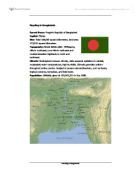
Densely populated or highly developed, low-lying coastal areas such as Bangladesh, the Nile Delta and Florida, coral profile islands like the Maldives and major estuaries including some of those in the UK will also be especially at risk. Where flood defences exist, they will need to be improved or set back. Where they don’t exist defences need to be developed or a retreat, managed or unmanaged should be adopted [1].
10.5 El Nino
In recent years the frequency of floods in Bangladesh has increased substantially [3]; where monsoon floods would typically cover 20% of the territory one year out of two, 40% has been found to be affected. This is thought to be due to a number of compounding factors such as:
- Local sea level rise
- Inadequate sediment accumulation on flood plains
- an increase in catchment area due to tectonic activity
- river narrowing due to damming and siltation
- soil erosion
- deforestation
- snow melting increase on Himalayas
- variation in tropical cyclones due to the effects of El Nino
The USA National Meteorological centre concluded that the extreme flooding of the Mississippi basin during the 1990s could have been directly influenced by the sea-surface temperature anomaly in the Pacific Ocean associated with ENSO. The relation between rainfall in Australia and changes in ENSO are also debated. Some believe that 1/3 of the total variance in seasonal rainfall is accountable to El Nino while other parties argue that although strong, consistent relationships between ENSO and rainfall have existed for many years they are subject to sudden changes that do not appear to be linked to any other phenomena [3].
10. 6 Other Sources of Flooding – Cloud Seeding
The theory of cloud seeding has recently surfaced amongst Internet news groups as a ‘conspiracy theory’ behind the modern increase in flooding events. The technique of cloud seeding involves firing particles of salt, dry ice or silver iodide into clouds so that they become heavy enough to produce rain. A United Nations ban prohibiting the use of cloud seeding or any other weather modification techniques for combat purposes has been in force since 1978, although it is believed by some that scientists have been conducting such experiments for several decades. However, cloud seeding is thought to have rarely been successfully anywhere in the world and consequently officially the Met Office had not pursued this line of research for many years [10].
- Engineering and Remediation
As figure 8 shows there are two basic approaches to countering flood hazards, structural (engineering approach) and non-structural (behavioural approach).
The engineering approach to counter flood hazards has been traditionally adopted by those standing to lose property and income in urban areas and by large landowners who will benefit from increased land values in rural areas. Engineering structures are highly visible (see figure 9), and their presence often indicates that positive actions have been taken against floods, and so are often politically implemented; flood defence is normally a massive part of a national budget. However some argue that engineering methods can lead to false sense of security and can increase the problem by encouraging urban development of flood plains and prone areas. This is a false economy as further intensive development may lead to higher damages than would have otherwise occurred.
Table 3: Engineering Solutions
There are many types of flood proofing that can be fitted retrospectively to housing in order to alleviate the problems of flooding as can be seen from table 4. Other measures taken to decrease the impact of flooding include simple low-tech ideas such as tilling rather than carpeting, installing floor drains, fitting electric wires high up on walls and creating high storage space. These types of action are known as wet-proofing and can be effective if not popular ways of reducing economic damage.
Table 4: Methods of flood proofing to individual homes
12. Environmental Impact of Flood Defences
River engineering works, including flood defences, lead to more uniform flow and channel conditions consequently limiting biological diversity especially that of benthic invertebrates, fish communities and aquatic birds [1]. Reductions in over-bank flows have decreased areas of wetland flora and fauna and alteration of river courses (such as straightening) impacts on the whole river corridor ecosystem. Channel form reshaping reduces the number of plant species present on the riverbanks. Accordingly proposals for new flood engineering works in more developed countries now often include statutory public participation in planning and decision processes. Modern designs for terracing and channelling can often be designed with the environment in mind, see figures 10 and 11.
The long-term strategic policy for open coasts is to maintain natural processes wherever possible. These trends reflect the underlying important of large-scale movement and transport of sediment for shoreline evolution. Sea walls tend to cut off the supply of sediment to coastal marshes and lead to reduction in moisture content of silts and clays behind the wall leading to shrinkage. The elimination of tidal currents by estuary walls has led to silting of channels requiring dredging to maintain shipping routes. Modern policy in developed countries is to encourage barrages rather than barriers as these are non-permanent defences such as the Thames barrage and are only raised at time of need, reducing their environmental impact.
12. Social Economical factors of Developing Flood Defences
In the third world floods are increasingly viewed as the triggers of disaster that has been founded by civil war, foreign debt, uncontrolled urbanisation and poor building construction. Anthropologists suggest that large-scale flood development projects are unsuitable for these countries as they can substantially increase the national debt for little economic return [1]. The effect on the individual can also be large, for example, in countries such as Bangladesh the size of land needed may be reduce land for cultivation to an uneconomic area. A combination of non-structural methods with cheaper structural methods such as embankments and levees should be considered in these areas.
Alternative methods of living with flood hazard:
- More raised community flood shelters and health clinics with food, water and sanitation
- Secured storage to preserve capital assets like cooking equipment that is needed to resume normal lives
- Protection of incomes by employing flood victims in the repair of embankments
- Improved design and construction of boats for emergency evacuation, security patrols and temporary housing in floods
- Flood-resistant infrastructure to maintain community services such as water, electricity, health and education during floods
- More flood resistant housing built away from areas suffering from severe riverbank erosion
14. The Future
Unfortunately the problem of flooding is set to get worse as populations grow, agriculture and urbanisation increase as climate change progresses; the problem is fundamentally human in origin. The more developed countries should be able to employ technology successfully to lessen impacts, for example flood defences in the Netherlands are reliable and an essential part of their land management. This would initially suggest that any future harm from flooding to the richer nations could be confined to economic damage. However, as technology progresses more and more catastrophic events will be needed to break the defences and any lapse in them could cause substantial injury and loss of life. A combination of land management policies, perhaps statutorily controlled with all the engineering solutions is needed.
The outlook of the lesser-developed countries outlook is set to get worse as population explosions are ongoing and uncontrolled urbanisation and land mismanagement is rife.
15. Conclusion
Coastal and river floods are caused by a number of extreme natural events intensified by the interaction of man with the environment. Flooding leads to major disasters involving loss of life and economic damage. The trend is for flooding to increase, and it should continue to do so as it is exaggerated by climate change, urbanisation and agriculture. The effect of temporary factors such as El Nino is inconclusive. Although technology is advancing it is unlikely to counter the predicted increase of events totally and the outlook for lesser-developed countries is not good. Therefore adoption of engineering and behaviour remedies is needed to limit the negative effects of the environment.
16. References
- Smith, Keith and Ward, Roy. Floods, Physical Processes and Human Impacts. John Wiley,1998.
- http://www.fema.gov/nfip/caeval9.htm
- www.greenpeace.org/~climate/flood_report/index.html
-
EM-DAT: The OFDA/CRED International Disaster Database (office of US foreign disaster assistance http://www.usaid.gov/hum_response/ofda/)
- Kemp, David D. Global Environmental Issues – A climatological approach. Second Edition, Routledge, 1994.
- IPCC. The Regional Impacts of Climate Change. WMO, 1998.
- http://lists.uakron.edu/geology/natscigeo/Lectures/streams/Miss_flood.htm
- The Daily Telegraph website
- Warrick, Bolin, and Jager, Doos (ed). The Greenhouse Effect, Climate Change and Ecosystems. SCOPE and ICSU, 1989.
- Midgley, P. Groundwater Flooding: a time to run? Circulation, 45, 13-14. 1995.
- Bradley, Raymond S. Paleoclimatology – reconstructing the climates of the quaternary
- http://www.ryerson.ca/vtoronto/wwwsite/themes/cultrec/html/sherwood.htm
- www.greenwich-peninsula.co.uk/ vision/ecology.htm