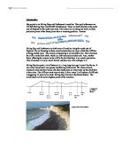
A diagram of the “seven sisters.”
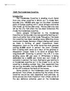
A photo of the “Seven Sisters”
The coastal process of Birling Gap is long-shore drift. Long-shore drift is the process by which a current moves sediment along a surf zone. The long-shore drift at Birling Gap flows from east to west. Also Birling Gap has a wave cut platform, this is where the waves have eroded away the cliff leaving behind a platform of rock, which you can see once the tide goes out.
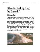
This is a photo of the wave cut platform at Birling Gap.
Since this photo was taken, the lighthouse (belle tout) in the picture has been removed from the sea and moved further back. This process is called managed retreat. Managed retreat is moving an object back from the sea to prevent it from falling in. It is not allowed to let buildings fall into the sea. This is expensive but necessary. This particular job cost in excess of £250,000.
Photo of a wave cut platform and the lighthouse.
Task
Having completed my fieldwork, I am being asked to structure a report, which will attempt to challenge the hypotheses that state –
- The pattern of beach material along the coastline reflects natural beach processes.
- Destructive beach profiles are steeper in gradient than constructive beach profiles.
- Some parts of the East Sussex coast are managed better than Birling Gap.
- Coastal management decisions do not reflect the land use of the surroundings.
Method
At each location I needed to collect information such as the name, grid reference, draw a field sketch, write a site description and find out the issues concerning coastal management. I need to level the beach profile and find out the direction of long shore drift. Landscape evaluations, Bi-polar scales, field sketching and photographs were very useful for this bit. All the information collected will help me write an illustrated description of each area. This plus other evidence should enable me to be able to accept or challenge the hypothesis’ proposed.
Hypothesis 1
Hypothesis 1 consists of the size of beach particles along and up the beach, whether there small, large, chalk, flint shingle sand etc. What processes operate like swash and backwash and long shore drift? And then I have to answer the question how are those processes linked to natural processes? And then find out and state whether it is true or false.
These 3 graphs (fig.1, 2, 3, 4, 5,6) are showing average rock size for Birling gap, rock type for both and rock size for both.
I also have some other graphs for beach profiles at birling gap and Eastbourne, long shore drift at Eastbourne and Birling Gap (fig 7,8 fig 9) these processes at Eastbourne do not compare (that much) to natural processes. Because if you look at figures 1 and 2 you will see that Birling Gap has a weak positive correlation and Eastbourne’s results are all over that place with no correlation. This shows that the average rock size it completely different at Eastbourne because of the way the council always has to move the shingle around to help manage the beach properly.
Hypothesis 2
I found out that the gradient for:
Birling Gap – 1:8
Eastbourne – 1:7
I got these results from my beach profile graphs. (Shown below.) These graphs show the definition of the beach.
Also, I counted the waves at both places. Constructive waves are waves that break every 9-10 seconds (6-7 a minute). Destructive waves are waves that break more frequently (12-15 waves a minute). At both places the wave count was high rendering them destructive waves. The table of results for the wave count is below.
Destructive waves have a strong backwash and transport material on the beach into the sea. The beach material that goes into the sea leaves a steep gradient behind.