GCSE Geographical Enquiry – A Study of a Market Town: Chester-le-Street
GCSE Geographical Enquiry -
A Study of a Market Town: Chester-le-Street
Introduction
Settlements vary in site, size, structure and function. This enquiry is based on Walter Christaller's central place theory, which is linked to population, threshold, range and sphere of influence. Threshold is the number of people that it takes to sustain a service, range is the distance someone is willing to travel to obtain a certain good and the sphere of influence is a circle around the central with the range as it's radius. Christaller's central place theory is that the population of a settlement affects the services and goods available. He also stated that people were willing to travel further to buy comparison goods than they would to buy convenience goods. Comparison goods are goods that cost a lot of money and are bought rarely, whereas convenience goods are bought regularly and cost little money. The hypotheses that I will test in my enquiry are as follows:
Hypothesis 1 - Chester-le-Street offers a wide range of goods and services
Hypothesis 2 - Chester-le-Street's sphere of influence is directly related to the goods and services that are available.
Hypothesis 3 -Pelton offers a narrower range of goods and services than Chester-le-Street.
Hypothesis 4 - Pelton 's sphere of influence is directly related to its goods and services, and will therefore be smaller than that of Chester-le-Street.
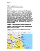
I am investigating the shopping patterns of Chester-le-Street, by first making deductions based on Chester-le-Street itself, and field work conducted in it. The map above shows the situation of both Chester-le-Street and Pelton in relation to other settlements in the area in County Durham. Chester-le-Street is an ancient market town, situated between Newcastle and Sunderland. Although the function of this town was once to provide a trading place for farmers in the region, it now is home to many commuters who travel to work in neighbouring cities, as the town is situated approximately six miles from Durham City, nine miles from Sunderland, and eight miles from Newcastle. Chester-le-Street is also a district council, which includes Bournmoor, Lumley, North Lodge, Ouston, Pelton, Pelton Fell, Edmondsley, Sacriston, Grange Villa, Urpeth, Holmlands Park, Waldridge, Kimblesworth and Plawsworth. The market is still a popular feature, as we found out while conducting our survey. I then hope to prove my conjectures by comparing Chester-le-Street to another settlement in it's locality of a different situation on the settlement hierarchy. For this I shall use Pelton, a village just outside Chester-le-Street. Being a market town places Chester-le-Street in the middle of the settlement hierarchy, which is shown below.
This is an order of settlements in which the settlements with the largest populations are at the top and the ones with smallest populations are the bottom. The higher up the settlement hierarchy the settlement is, the more goods and services it offers. This is because the population of the place increases as we move up the hierarchy, and it can therefore support more goods and services.
Hypothesis 1
In this hypothesis I wish to prove that Chester-le-Street offers a wide range of goods and services. As a market town, according to the settlement hierarchy shown above, Chester-le-Street should offer a wide range of goods and services, with more variety than a village, and less than a town or city. I will investigate this in the manner described below.
Methodology
To ascertain what the available shops and services in Chester-le-Street were, and what type of goods they dealt in we performed fieldwork in Chester-le-street. We collected data about the shops and services that were in Chester-le-Street by walking up and down Front Street in groups, writing down all the names of the shops and services that were on the ground floor. We chose Front Street because it is the main commercial street in Chester-le-Street. Two people recorded the buildings on one side and two recorded those on the other. We chose this method, as maps of the area would not be accurate enough, and may need updating. Once we had recorded this data, we divided the shops into types and groups, to make it clearer for us to see the types of services and goods that were available. The groups we organised the shops and services into were as follows:
> Inexpensive goods
> Averagly priced goods
> Expensive goods
> Health and beauty services
> Travel/estate agents
> Law and finance
> Other
> Food outlets and restaurants
I chose these categories after looking at the information that we had collected, and decided that the above groups gave the widest picture, and therefore most accurate, of the goods and services that were available in Chester-le-Street, as opposed to simple categorising them as inexpensive goods, averagly priced goods, expensive goods and services.
To complete this hypothesis we collected data from the main street in Chester-le-Street, which is Front Street. This is highlighted on the map shown below:
Interpretation
My results show that there is a reasonably wide range of goods and services available in Chester-le-Street, as there is a selection of services in all of the categories that were determined upon, and there is a selection of all colours in the key used in the land use map. This shows that there are a variety of goods and services available in Chester-le-street. The bar and pie charts ...
This is a preview of the whole essay
To complete this hypothesis we collected data from the main street in Chester-le-Street, which is Front Street. This is highlighted on the map shown below:
Interpretation
My results show that there is a reasonably wide range of goods and services available in Chester-le-Street, as there is a selection of services in all of the categories that were determined upon, and there is a selection of all colours in the key used in the land use map. This shows that there are a variety of goods and services available in Chester-le-street. The bar and pie charts show that more people come to Chester-le-Street to buy convenience goods, than come to buy comparison goods. Food outlets and restaurants are also often found in Chester-le-street. There are many other services also available on Front Street, which is shown on my land-use map.
Analysis
The outcome of my results is as it is for several reasons. There is a wide range of goods and services available in Chester-le-Street because there is a large population of people in the surrounding area that need the shops in their everyday lives. There will be many food outlets here because people from the surrounding area come simply to buy their necessities of life. Most people will travel to Chester-le-Street to buy convenience goods rather than comparison goods because there are not many shops in Chester-le-Street that sell comparison goods, and the cities of Newcastle and Durham are near by, and there can be found there a wider range of goods and services. This is shown on the bar and pie charts. It is also supported by my questionnaire, from which I made the bar chart shown here:
I think that this is because the population of Chester-le-Street is not large enough to sustain more expensive shops, according to Christaller's theory of threshold. This is the number of people that are needed to keep a certain type of shop in business. Shops selling convenience goods need few people, as those people will buy often, whereas those buying comparison goods will seldom make a purchase, and more people are therefore needed. This can be seen through the fact that shops such as Radio Rentals, which provides electrical equipment for hire and purchase, have closed down. Most people will travel through Chester-le-Street by car because many people in Chester-le-Street commute to other areas for employment. We can therefore see that Chester-le-Street does offer a wide range of services, although only as many as can be sustained by the surrounding community. This coincides with Christaller's central place theory.
Evaluation
The reliability of my results could have been improved in several ways. The landuse plan was done well, and yet could have been improved by taking into account the first floor uses as well as those on the ground floor. It could also have been improved by showing which shops were closed down, and which were left without lease. I could also have questioned businesses based in the locality, to find out which sorts of goods sold best, and the numbers of people that visited the shops per day, week and year. This would have helped me as I could have seen through numerical fact that shops were most popular, and therefore what sorts of goods sold best.
Hypothesis 2
Introduction
In this hypothesis I wish to prove that Chester-le-Street's sphere of influence is directly related to the goods and services available there. To do this I will use the method described below.
Methodology
To determine Chester-le-Street's sphere of influence we found out where people travelled from to shop in Chester-le-Street by interviewing 20 people, and asking them to answer a questionnaire. We decided to do this because it would be the most effective way of gathering this information. Our choosing people at random also meant that we collected information from people of various sexes, ages and backgrounds, as opposed to our results if we took them next to a particular shop or by a bus stop, as these people would have certain things in common. We also took traffic and pedestrian counts in different areas of the street, as those travelling by car will be likely to have travelled further than those on foot.
Interpretation
My results show, through my pedestrian and traffic counts, that there are more cars travelling through Chester-le-Street town centre than there is any other form of transport, besides people walking on foot. From my questionnaires it can also be seen that most people that come to Chester-le-Street come to benefit from the convenience goods and the services rather than the comparison goods. I have been able to calculate from my questionnaires, an average distance travelled into the centre of Chester-le-Street, which means that I can also draw a sphere of influence. This is shown on the following page, where I have also placed a map with the sphere of influence drawn onto it. The average distance travelled, according to the people that I interviewed, was 3.1425 miles.
Analysis
My results show the above stated factors for several reasons. Firstly, more people arrive in Chester-le-Street by bus than by any other way because people are unlikely to travel long distances for convenience goods, which my questionnaires show is the main type of goods that attract people to Chester-le-Street. Most people come to Chester-le-Street because there is a limited amount of goods available there, but a good supply of convenience shops, selling cheap goods, as shown my bar charts and pie graphs, shown here:
For comparison goods most people are willing to travel to a neighbouring city, such as Newcastle or Durham, both of these being quite close by. My questionnaires also show that most people feel the range of goods available in Chester-le-Street to be average. This is shown in this graph:
This shows why people won't buy comparison goods in Chester-le-Street, as people will buy comparison goods at places where there are many opportunities to compare the price and suitability of goods, and therefore places that are considered to have a very good selection of goods available. Chester-le-Street, according to the graph shown above, is not included in this category. This will make the sphere of influence smaller, as more people will go elsewhere to buy their goods, therefore showing that the sphere of influence of a town is directly related to the range of goods available. The sphere of influence in shown on the previous page, the average distance travelled being worked out at 3.1425 miles to shop in Chester-le-Street. This means that this is the range. This will be strongly affected by the proximity of the Metro Centre, Newcastle and Durham, as all have a wide range of shopping facilities and services.
Evaluation
The results of the questionnaire could have been improved by asking more than twenty people to complete it, and the results could have been taken on several different days, to give a wider variety of results. They could, perhaps, have been taken once on a market day and compared to those collected on a day that was not a market day. This would have shown more clearly how many people came to Chester-le-Street for the market. The pedestrian and traffic counts could have also been taken on several different days, one market and one not, and at more varying times of day. One could have been taken in the morning, one at lunchtime, and one in the evening or at night. However, the results that have been recorded are reliable and are sufficient to draw conclusions from. It could also have been improved by talking to local bus companies, to ask where most people that come to Chester-le-Street come from. For this reason we could have also looked at the buses themselves, to see where buses that came through Chester-le-Street were coming from and going to. I could have also improved my results by calculating how many people lived within the sphere of influence, and how big the area within it was.
Hypothesis 3
Introduction
In this hypothesis I wish to prove that Pelton offers a narrower range of goods and services than Chester-le-Street. As a village, according to the settlement hierarchy shown in the main introduction, Pelton should offer little variety in goods and services, with more variety than a Hamlet, and less than a market town. The location of Front Street in Pelton is shown here, marked in red. I will investigate this in the manner described below.
Methodology
I collected data in Pelton in exactly the same way in which I collected it in Chester-le-Street, in order to make sure that all my experiments were fair. Therefore, to ascertain what the available shops and services Pelton were, and what type of goods they dealt in I performed fieldwork in Pelton. I collected data about the shops and services that were in Pelton by walking up and down the main street, again called Front Street, writing down all the names of the shops and services that were on the ground floor. I chose Front Street because it is the main commercial street in Pelton. I recorded the buildings on both sides of the street. I chose this method, as maps of the area would not be accurate enough, and may need updating, as well as the fact that this would be parallel to the data I had already collected in Chester-le-Street. Once this data had been recorded, I divided the shops into the same types and groups that I divided Chester-le-Street's shops into, to make it clearer for me to see the types of services and goods that were available. The groups I organised the shops and services into were as follows:
> Inexpensive goods
> Averagly priced goods
> Expensive goods
> Health and beauty services
> Travel/estate agents
> Law and finance
> Other
> Food outlets and restaurants
I also conducted 20 questionnaires on Pelton Front Street, including the same questions as those on the questionnaires taken in Chester-le-Street, excepting the final question regarding the market, as Pelton does not have a market.
Interpretation
My questionnaire shows me that almost everyone who shops in Pelton lives within walking distance, as only three people out of the twenty that I interviewed did not get to Pelton by foot. My land use map shows me that there are more shops that sell inexpensive goods and food outlets than any other category of land use. This is shown in the graph shown here:
As can be see from the above graph, there were no law & finance, travel & estate agents, or and shops selling expensive goods. In addition, most people rated the range of goods available in Pelton as poor. This is shown in the tally chart shown here of people's opinions:
Opinion
Tally
Frequency
V. good
-
0
Good
-
0
Average
|||||
5
Poor
|||||||||||||||
5
Everyone that came to Pelton came to buy convenience goods alone, or convenience goods and services. Also, most people that shopped in Pelton shopped there more than twice a week.
Analysis
I believe that the reason for so many of the people I interviewed having arrived in Pelton on foot is because Pelton has a very limited range of goods available, and people are therefore not willing to travel far enough to justify taking some other means of transport than walking. Pelton's range of goods is so limited because it does not have a population big enough to sustain shops that sell more expensive goods. In addition, legal and financial advice is not needed on a regular basis, and so will not make a profit in a small village. This also applies to travel and estate agents. The fact that most people chose to say that the range of goods available in Pelton was poor shows that people would not be willing to shop there for expensive goods. This is supported by the fact that there are no expensive shops, and far fewer of all types of shops than there was found in Chester-le-Street. This graph shows how often people shop in Pelton:
There were no people that shopped less often than weekly. I believe that this is because the goods that are bought in Pelton are such that they are needed for everyday life, and are considered to be basics. We can, therefore, see that Pelton offers a much narrower range of goods than Chester-le-Street.
Evaluation
This hypothesis could have been improved in several ways. The landuse plan was done well, and yet could have been improved by taking into account the first floor uses as well as those on the ground floor, although there weren't as many commercial projects going on the first floor of the buildings in Pelton as there were in Chester-le-Street. It could also have been improved by showing which shops or services were closed down, such as the working men's club, which would be classed as a service. I could also have questioned businesses based in the locality, to find out which sorts of goods sold best, and the numbers of people that visited the shops per day, week and year. This would have helped me as I could have seen through numerical fact that shops were most popular, and therefore what sorts of goods sold best.
Hypothesis 4
Introduction
In this hypothesis I wish to prove that Pelton 's sphere of influence is directly related to the goods and services available there, and that it is smaller than Chester-le-Street's. To do this I will use the method described below.
Methodology
To determine Pelton 's sphere of influence I found out where people travelled from to shop in Pelton by interviewing 20 people, and asking them to answer a questionnaire. I decided to do this because it would be the most effective way of gathering this information. By choosing people at random meant that I collected information from people of various sexes, ages and backgrounds, as opposed to my results if I took them next to a particular shop or by a bus stop, as these people would have certain things in common. I also took traffic and pedestrian counts in the middle of the street, as those travelling by car will be likely to have travelled further than those on foot. I then calculated the average distance travelled, and compared it to that of Chester-le-Street.
Interpretation
My results show, through my pedestrian and traffic counts, that there are more cars travelling through Pelton town centre than there is any other form of transport, besides people walking on foot. The results of my traffic and pedestrian count is shown here:
Type of transport
Tally
Frequency
Car
|||||||
7
On foot
|||||||||||
1
Bus
||||
4
Van
-
Lorry
-
Other
||
4
From my questionnaires, it can also be seen that most people that come to Pelton come to benefit from the convenience goods and the services rather than the comparison goods, as is shown in the analysis below. I have been able to calculate from my questionnaires, an average distance travelled into the centre of Pelton, which means that I can also draw a sphere of influence. This is shown on the map below, where I have drawn Chester-le-Street's sphere of influence, in order to show a contrast. The average distance travelled, according to the people that I interviewed, was 1.216 miles, in contrast to that of Chester-le-Street, which was 3.1425 miles. Chester-le-Street's sphere of influence is shown in red, and Pelton's is drawn in purple.
Analysis
My questionnaires show that most people come to Pelton for the convenience goods and services. This is shown in this graph:
This shows that no one shops in Pelton for comparison goods, for which reason there are no shops selling goods that are more expensive. This is because the population of Pelton is not sufficient to sustain shops selling expensive goods, or a wider range of services. Because of this very limited selection of shops and services the sphere of influence will be much smaller than that of Chester-le-Street, as more people will go to Chester-le-Street, the Metro Centre, Newcastle and Durham to buy their goods. The sphere of influence will be strongly affected by the proximity of the Metro Centre, Newcastle and Durham, as all have a wide range of shopping facilities and services. This shows that the sphere of influence of a town is directly related to the range of goods available. I can also see this because of the greater size of Chester-le-Street's sphere of influence in comparison to Pelton's. The sphere of influence is shown on the previous page, the average distance travelled being worked out at 1.216 miles to shop in Pelton. This means that this is the range. This therefore supports my hypothesis.
Evaluation
The results of the questionnaire could have been improved by asking more than twenty people to complete it, and the results could have been taken on several different days, to give a wider variety of results. They could, perhaps, have been taken at different times of the day as well. This could also be applied to the traffic and pedestrian counts. One could have been taken in the morning, one at lunchtime, and one in the evening or at night. However, the results that have been recorded are reliable and are sufficient to draw conclusions from. Also, it would have improved these results to take into account that the main road through Pelton is a through road to Chester-le-Street, an so could have been headed there. It could also have been improved by talking to local bus companies, to ask where most people that come to Pelton come from. For this reason we could have also looked at the buses themselves, to see where buses that came through Chester-le-Street were coming from and going to. I could have also improved my results by calculating how many people lived within the sphere of influence, and how big the area within it was.
Final Conclusion
In conclusion, I can say that my four hypotheses all support Christaller's theory's of range, threshold and sphere of influence. The contrast between the sizes of Chester-le-Street's sphere of influence and Pelton's, due to the differences in the goods and services, support the above three, therefore ultimately Christaller's Central Place theory.
Final Evaluation
Overall, this is an accurate and reliable picture of shopping patterns in Chester-le-Street and Pelton, although several improvements could have been made. Firstly, conducting more questionnaires would give a much more accurate picture of the sphere of influence, and would give a wider view of people's reasons for their shopping habits. Taking into account closed shops and services would also have made my final results more accurate. Talking to local businesses would also have given figures that would be much more accurate than my own.
Sally Gall