Michael Diamond
Block C
December 6, 2007
Mr. Cheatle
The tectonic setting, landforms and hazards of Taal Volcano
Introduction:
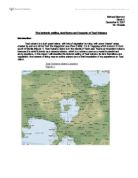
Taal volcano is a lush green island, with lots of vegetation but also, with some “desert” areas, created by ash and cinder from the Kaygabok Lava Flow (1969). It is in Tagaytay which is about 2 hours south of Manila (Figure 1). Taal Volcano Island is in the middle of Taal Lake. Taal is an important volcano because it is what is known as a decade volcano, which is a volcano used as a model to predict and study eruptions. In this report I will describe the tectonic setting of Taal volcano, its land formations and vegetation, the hazards of living near an active volcano and a brief description of my experience on Taal Island.
Tectonic setting:
Taal volcano is found in Batangas, its precise latitude and longitude are 14°0′7″N 120°59′34″E. It is located along the western region of the Pacific Ring of Fire which is named for its high volcanic activity. Taal Volcano Island was created by the Philippine plate (Oceanic plate) crashing into and going under the Eurasian plate, which formed a subduction zone underneath the Philippines Mobile Belt. In the west, the oceanic part of the Eurasian plate (South China Sea basin) is being subducted under the 560-mile length of the Manila and Sulu trenches. This produces a scattered line of active volcanoes from Taal to Iraya in the small islands north of Luzon. However, between the two gigantic plates are 4 microplates being squeezed together, with Taal being on the smallest micro plate, it’s western boundary being pushed by the Eurasian plat while it’s southern boundary and eastern boundary are transform margins (Figure1.1). This means that Taal volcano lies on a conservative margin known as the Philippine Fault but there are two subduction zones and the fault connects the two subduction zones, which makes the plate margin destructive (Figure 2).
Landforms and vegetation:
Before Taal Volcano erupted, it was believed to be an immense pre-historic volcano, standing an estimated 18,000 feet high, and then 500,000-100,000 years ago, 4 giant explosions destroyed the volcano and it collapsed into a caldera, with a channel opening towards Balayan Bay. This destructive eruption created Taal Lake, which lies within the 25-30 km caldera. Originally, Taal Lake was connected to the sea but in 1754 a powerful eruption from Taal Volcano reshaped the outlet, to form the present day Pansipit River, this diluted the water, turning it into fresh water, now this is the lake’s only outflow. Taal Lake is 234.4 km2, the Main Crater Lake, where tests are taken to predict eruptions, is 2 km wide and 80 meters deep and Taal Volcano which is a 23 sq km post-caldera feature with, numerous eruption centers.
In Taal there are about 35 volcanic cones, and 47 craters or depressions caused by direct eruptions or ground subsidence. However, the Main Crater Lake is where 12 of Taal’s eruptions took place, while the five major eruption centers are namely Binintiang Malaki, Binintiang Munti, Pira-piraso, Calauit and Mt. Tabaro (Figure 3.1). There are many different landforms in Taal but the more recognizable features include, Mt. Tabaro, where the 1968 eruption took place, the 1968 eruption created the Kaygabok Lava flow and the Main Crater Lake. All over the island, there is lots of tephra, tephra is airborne ejecta from a volcano, the types of tephra that we found on the island were ash, a very fine rock and mineral particles, and cinder which is a fragment of cooled pryoclastic material. The reason these tephra are found here is because of the pryoclastic flows and ash cloud eruptions from the volcano. Towards the area of Mt. Tabaro, there is very little vegetation, which makes the area very hot and dense. In contrast, the Kaygabok Lava flow area contains lots of vegetation, because of the fertile soil it produces due to the minerals, which make the plants, grow well. The reason there are large rock like structures in the Kaygabok Lava flow area is because they are hardened lava. The proper term for this rock is olivine basalt, while it’s generic term is scoria, scoria is made of iron magnesium silicate (FeMgSiD4), it’s formed when lava solidifies, leaving little holes known as vesicles, this makes the rock both light and porous. The Main Crater Lake is in the central area of the Volcano Island, here there is concentrated vegetation because of the tephra, and you can also swim in the lake, if there are currently no alert levels (Figure 3.1).