
York Flood Management Report
Geography Stephen Mathieson York Flood Management Report The city of York was originally built in a superb defensive position, it was an island almost completely surrounded be water from the river Ouse and the river Foss. With York being surrounded by the Vale Of York it is often under threat from flooding, records of flooding in York go back to the 14th century, but many archaeologists believe that York suffered from a major flood during Anglo-Saxon times. The worst flood witnessed by York happened in 1947 when the river Ouse burst its banks. This was due to the thaw of the river as it was frozen solid, it was so hard that a horse and cart were able to cross the river. York was again hit by a major flood in 1982 when flood levels reached 16feet high. York is often under threat to flooding because of its situation. The river Ouse is the principal drainage basin in Yorkshire. The Ouse is formed by the confluence of the Ouse, Gill, Beck and the river Ure, a few kilometres downstream of the confluence of the rivers Swale and Ure. The Ouse the flows southwards and is joined by the Nidd just to the north of York. The river Ouse meets the river Foss directly in the heart of the city centre. The tributaries of the Wharfe, Derwent, Aire and Don all join the Ouse further downstream before it meets the Trent to become the Humber Estuary.

Case Study: Water Management Scheme/Flood Control
Case Study: Water Management Scheme/Flood Control Aswan Dam, Egypt * The Aswan Dam is in Egypt, which is in Africa. The dam is on the river Nile which is 6698km long, the dam is 3600km and extends 480km into Sudan. * Aswan is about 200km away from the Egyptian coast bordering the Red Sea * Is about 700km south of Cairo - the capital of Egypt * About 800km South of the Mediterranean Sea * About 230km North of the Border of Sudan * About 800km West of the Border of Libya The features of the dam were: * To prevent flooding of the land around the river Nile. * Provides Electricity - 12 turbines that generate over 10 billion kilowatts of electricity every year. * Provides a more reliable source of water for increasing population. * Enabled fish to breed in the reservoir so more fish can be caught and used at food. * The scheme was necessary because the Nile over flowed and flooded the land around it for 2-3 months of the year which made farming hard as the farmers never knew when the Nile was going to flood and how long the floods will last, meaning that they get less food for them to survive on. The dam created a huge reservoir, which was to, controlled the flooding. * Millions of tons of sediment that was used to fertilise the farms now gets trapped in the dam. The farmers now have to use chemical fertilisers, which costs them a lot money and causes pollution. *
Compare and comment on the flood management approaches in two contrasting areas of the world
Compare and comment on the flood management approaches in two contrasting areas of the world. (15) Flooding affects many countries around the world. A flood is a high flow of water that overtops the banks of the river channel and spreads out onto the flood plain. Floods are one of the most common environmental hazards that affect people living in lowland valley areas on the floodplain and in low lying coastal areas. The nature and scale of flooding varies greatly depending upon where it occurs and thus different flood defenses have to be created for the type of floods that happen. For instance in the UK, only 2% live on a floodplain, this is in contrast to the vast amounts of people who are in danger from flooding in Bangladesh. In low lying areas and active floodplains of Bangladesh almost 110 million people live fairly unprotected on the floodplains of the Ganges and the Brahmaputra. Floods here are commonly caused by the monsoon and often lead to 20-30% of the land in these regions to flood but in exceptional circumstances it has been known for half the country to be underwater. A good example was the 1998 flood that killed over 1500 people. The floods that hit the UK in 2007 for instance were caused by higher than average rainfall where in some places a months rainfall fell in a 24 hour period. There are four main ways to manage floods. The first being a structural
Londons Flood Risk
London's Flood Risks Investigate and explain how London's flood risk is being managed (10) A small number of steps have been taken by a few organisations in order to help in managing London's flood risk effectively. Mainly, the Met Office and the Environment Agency have been closely working together to manage London's flood risk. One of the physical measures that was built between 1974 and 1984, the Thames Flood Barrier, has been used over 100 times defensively and is the second largest flood barrier in the world. The barrier is raised for the duration of high tides and is then opened to allow the water to escape into the Thames. As mentioned above, the Met Office and the Environment Agency have been closely cooperating, working together to assess the potential impact of climate change in the South East. The information provided by the Met Office to the Environment Agency will be used to consider flood risk management strategies for the Thames Estuary up to 2100. The Thames Estuary 2100 (TE2100) is a project which "aims to determine the appropriate level of flood protection needed for London and the Thames Estuary for the next 100 years." London's existing flood defences will only provide protection up until 2030. So for this reason, investigating, planning and developing ways in which to tackle this issue now will allow time for necessary research and the chance to use the
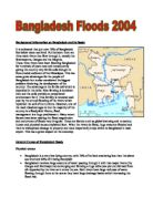
Banladesh Flood 2004
Background information on Bangladesh and its floods It is estimated that just over 70% of Bangladesh lies below mean sea level. Furthermore there are three main rivers that flow through it, namely the Brahmaputra, Ganges and the Meghna. These three rivers have been flooding Bangladesh for hundreds of years now and consequently giving the country very fertile soils brought in from eroded sediment of the Himalayas. This has some great advantages for the people of Bangladesh but is also considered the biggest problem hindering the development of the country. The advantage is the fertile soil which is deposited in the delta. Rice farming is dominant here and the soils provide an exceptional environment for it. This fertility is renewed each year by the annual flooding of the rivers which replenish the soil of its nutrients. However, one of the main disadvantages is that the majority of the country is a floodplain! Hence, flood management is a huge predicament. Many recent factors have been making the flood magnitudes and occurrence of floods very irregular. These are factors such as global warming and numerous human and physical causes explained later. When the rivers do flood, huge areas are flooded and there is widespread damage to property and most importantly crops which is Bangladesh's main export. This has a grave impact on the economy. General Causes of Bangladesh
Describe and evaluate water management strategies (excluding those directed at flood control).
Describe and evaluate water management strategies (excluding those directed at flood control). Over the past 60 years agriculture, industry and domestic use caused an increase of water use from 1000 cubic kilometers to 5000 cubic kilometers per annum. If current trends continue to increase, water shortage will affect 3.5 billion people, 48% of the world’s estimated population, by 2025. In order to prevent water stress to such great extend, measurements and strategies of irrigation and agriculture, freshwater wetland, groundwater and damns and reservoirs were established. Dams and reservoirs certainly are one of the most important water management strategies. The barrier placed across the river Nile and the artificial store that lies right behind the dam together make the Aswan Dam, lying south of the city Aswan in Egypt. Hydroelectric power generation is water being stored behind the dam that drives the turbines and accounts for 45% of Egypt’s energy needed. Moreover, the dam provides water to crops during dry seasons, in times of drought or water scarcity and has irrigated an estimated of 3.4 million hectares of land, which lead to an increasing profit of Egypt’s economy. As well, the Aswan Dam is used to regulate the fall of the Nile up – and downstream, having a better outcome on the navigation of Lake Nasser and on tourism, as the dam became an important
Bangladesh flood
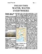
ENGLISH TIMES WATER, WATER EVERYWHERE Bangladesh floods again! Is this another 1988 flood? Bangladesh only exists because of the flooding that occurs each year and the rivers that flow through. Bangladesh is 80% delta which is low lying land and could be washed away at anytime. Even an extra meter of water can have disastrous affects. This also means that 80% of the land is a flood plain. It is expected the land will flood with 30% of the land being flooded which is an area the size of Wales. But is only considered a 'big' flood and abnormal if more than 30% of the land is flooded. (Source 1) Flooding in the 1988 Bangladesh flood. Bangladesh is one of the most crowded countries in the world. Compared to the U.K. there are twice as many people in almost half as much space. The population in Bangladesh is 124,774,000 and in England 58,649,000. But Bangladesh is also a poor country 77% of the population live in the rural countryside to farm the land, in the united kingdom only 11% live in the countryside because we are a developed MEDC. Many people in Bangladesh have to live here because farming is the only way that they can get enough money and food to survive. This causes a major problem when there is a flood, and many more lives are lost. Bangladesh is bordered by Nepal and India with the Bay of Bengal at the South of the country. Three large rivers run through the

A flood hydrograph
A flood hydrograph is a graph of two axis, 'discharge' and 'time'. Plotted on the graph is the amount of discharge over a period of time. By looking at a hydrograph, a lot of information and data can be gathered about the river, the precipitation, the surrounding area and vegetation etc. The gradient, height and length of a line can tell you a lot of this information. There are many different factors that can affect the appearance and shape of a hydrograph. Certain conditions can cause the line on the hydrograph to be tall and thin and other conditions can cause it to be short and wide. Peak discharge is the term used to describe the maximum amount of discharge from the river over the period of time recorded; this peak discharge can be high or low depending on a lot of conditions. Climatic factors are the most obvious conditions that can affect the flood hydrograph. If the precipitation is very intense and there is a lot of it then the hydrograph is likely to have a high peak discharge where as if the precipitation is low-intensity and there is a small amount then the graph will have a gentle ascending limb. The ascending limb is the first part of the line on a hydrograph that rises to the peak discharge. If the gradient is steep (like the example on the right) then this can indicate that the amount of rainfall becoming overland flow is very high, the result of this
The Flood Tribunal
The Flood Tribunal A Tale of Three Witnesses by Vivienne Traynor . Liam Lawlor The revelations by spin-doctor Frank Dunlop were the real turning point for the Flood Tribunal in 2000. Initially, Mr Dunlop handled the tribunal's question with ease, but after a grilling by the Tribunal Chairman, when he threatened Mr Dunlop with the possibility of a spell in prison, he appeared to crack. In a memorable day for Tribunal stalwarts and the watching public, the political lobbyist finally appeared to crack. In April, after two and a half years of legal sparring, the tribunal finally discovered something people had long suspected. Mr Dunlop admitted that certain politicians were taking cash for votes on rezoning. He wrote the names of 15 politicians, who had taken sums ranging from £500 to £40,000, and he made particular mention to a very powerful, Mr Big. The journalists were ecstatic and Frank McDonald, the Irish Times Environment Correspondent, brought in clippings, which referred to politicians pocketing brown paper bags back in the early 90s. Liam Lawlor immediately denied that he was the "Mr Big" who pocketed the most from Dunlop's generous sponsors, but this didn't stop Fianna Fail from launching an investigation into Mr Lawlor. After a lengthy grilling by party colleagues, Liam Lawlor ended up leaving the party. (Fine Gael also launched a set of internal inquiries

2007 Flood report
Flooding in the UK - 2007 Due to the large amount of rain this summer, met office figures suggest that this has been the wettest summer since records began in 1914. The provisional figures show that this summer there was 358.5 mm of rain narrowly beating the record of 1956 in which we had 358.4 mm of rain fall. The main cause of this flooding was an unusually southerly jet stream. A jet stream is a band of very strong winds, these determine weather systems across the UK. For most of summer 2007 the jet stream was further south and a lot stronger than usual. This shows the jet stream in the Atlantic in summer 2007, in the summer the jet stream would normally travel north of the British isles and a lot high pressure to build drawing in warm dry weather. However in summer 2007 the jet stream has been persistently over the south of the British isles all summer not allowing that high pressure to build this means we have had low pressure near us nearly the whole time. As well as just being a nuisance this weather pattern has also caused lots of problems. When the river Severn burst its banks in Gloucestershire seven people died, and more than 350,000 people were left homeless and without clean water due to the water works being flooded. In hull a 28 year old man man died after becoming stuck in a drain, rescuers were unable to free him. Also two people died in Sheffield, the


