
Hard & Soft Engineering Coastal Management Case Studies
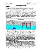
Hard & Soft Engineering Coastal Management Case Studies Hard Engineering - Coastal Management - Isle of Wight The Isle of Wight has 65 miles of spectacular coastline, 28 miles of which are designated Heritage Coast. This varied coastline is one of the Island’s main assets. The Isle of Wight has four coastal defence options: . Hold the Line – retain existing coastline – maintain current deference’s, upgrade or install new ones 2. Do nothing but monitor – it may not be technically, environmentally or economically possible to do coastal defence work 3. Retreat the line – this is used to manage the rate and process by which the coast retreats 4. Advance the line – build new defences seaward, in front of the land, to protect the land behind Monks Bay * Cliff failure after the 1990/91 severe storms gave motivation to upgrade coastal defence * Offshore breakwater, six rock groynes and rock revetment * This reinforced the existing sea wall – 25,000 tonnes - Norwegian granite * Beach nourishment was used – 40,000 m3 of sand * Re-profiling the slope and installing land drainage * This was to reduce the risk of Mass Movement Cost-benefit analysis – value of property exceeded £1.4 million cost * Completed in 1992 * £1.4 Million - but value of property exceeded this * Sediment in groyne has been a problem, as some has overtopped the rock
Longshore drift is a major movement that determines the sorting of pebbles on Lulworth Cove. The swash carries material obliquely up the beach, however the backwash carries it back down the beach by the steepest slope.
Coastal Collision Coursework Section B ) Longshore drift is a major movement that determines the sorting of pebbles on Lulworth Cove. The swash carries material obliquely up the beach, however the backwash carries it back down the beach by the steepest slope. Another wave will then move it up and across the beach once more. Materials slowly moved along the beach in a zigzag course, the effects of longshore drift can best be seen when wooden groynes have been put in place to prevent material from being moved along the beach. Materials such as sand and shingle may be deposited after reaching an area where the water is sheltered and the waves lack energy. This material maybe temporarily deposited to form a beach. Longshore drift at Lulworth Cove will prove my hypothesis; 'The pebbles are smaller on the windward side than the non-windward side'. Other processes occurring at Lulworth Cove that determine the shape of pebbles are attrition and abrasion. Attrition is where rock fragments themselves rub against each other, reducing their size and making them more rounded. Attrition would cause the pebbles on Lulworth Cove to break up and become rounder, smoother and less angular, hopefully proving my third hypothesis, 'The pebbles get smoother as you travel nearer the water.' Abrasion occurs when moving water bombards the cliff with rock fragments and drags others backwards and
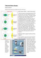
Geography Coastal Erosion - Tides and Storm Surges
Tides and Storm Surges What are tides? Tides are the periodic rise and fall in the level of the sea. What causes tides? How do they work? Tides are caused by the gravitational pull of the sun and moon, the moon influences the move of tides more as it is nearer. The water is pulled towards the moon this creates a high tide, on the opposite side of the earth there is a compensatory bulge. The tide is the lowest in the areas between the two bulges. The high tides follow the moon as it orbits the earth; there is a high tide every 12 hours and 25 minutes (twice a day). The moon sun and earth are in a straight line twice every lunar month this is when the tidal raising force is strongest and there is the highest monthly tidal range, this is also known as a spring tide. The opposite is when the moon and san are at 90 degrees of each other in relation to the earth, this gives the lowest monthly tidal range also known as a neap tide. What are storm surges and why do they happen? Storm surges are rapid rises in sea level when water piles up against the coast line.. When a tropical cyclone moves across or near the coast, it can cause sea levels to rise higher than the normal tide levels it is the result of the strong onshore winds and/or reduced atmospheric pressure. Storm surge may also be formed by intense low pressure systems. They are a major natural hazard especially in
“Samphire” By Patrick O’Brian
"SAMPHIRE" by Patrick O'Brian Sheer, sheer, the white cliff rising, straight up from the sea. Up there, unless you leaned over, you could not see the waves break, but for all the distance, the thunder of the water came loud. The wind tearing from the sea, rushing from a clear, high sky brought the salt tang of the sea to our lips. The two of us standing up there, on the very edge of the cliff. "It's a clumps of samphire, Molly" he said wit his high unmasculine voice. He then turned, "Molly, it is samphire. I said it was samphire, didn't I?" I had heard him the first time but I could not reply. My chin was trembling: there was something in the back of the throught. I could not have spoken if my life depended on it. I stepped closer, feeling for a firm foot hold. I was so close to him I could smell his tweed jacket. As he straightened so suddenly, it brushed against my skin. "hey look out, " he said "I almost trod on your foot". I could not answer, so I got on my hands and knees and crawled to the edge. Heights terrified me and could not close my eyes, which made it even worse. The noise of the sea assaulted my terrified mind as I clung insanely to the thin grass. Three times he pointed the shrub out to me "Fleshly leaves. You see the fleshly leaves? They are used for samphire pickles. " He laughed. He put his hand on my shoulder as he laughed. He followed
In this section I will be describing what my data shows for each of the techniques I used at Overstrand. Groyne measurements.
Analysis and conclusion In this section I will be describing what my data shows for each of the techniques I used at Overstrand. * Groyne measurements: Groyne measurement shows the height and how much sediment is being built up on either side of the Groyne. This allowed me to find out whether long shore drift was taking place. From looking at my graph I found out that there was more build up of beach sediment on the west than the east of the groyne. This was the sort of graph I wanted, where one was higher than the other. LSD is the transportation of beach sediment of beach sediment along the shore in a zigzag movement. Beach sediment splits as it moves on shore at Sheringham. Some of the sediment and water moves westwards towards Cley, whilst the other half moves towards Overstrand. On the coast, if there is any human implication, this will therefore disrupt the great level movement of beach sediment along the coast. A) Large groynes at Cromer (coastal management), very antagonistic. They capture movement of beach (buffer zone) therefore a decrease in the amount of beach sediment moving via LSD to Overstrand. To keep an imperative buffer zone in place, Overstrand must conduct coastal management. B) Due to recreational and agricultural land use, coastal management had been reduced along the coast of Cromer and Overstrand. Therefore, a decrease in the amount of

ExplainThe statement, "Coastal Management is more effective at Fairlight than at Camber".
Introduction and aims. Welcome to my investigation. In my investigation I will explain The statement, "Coastal Management is more effective at Fairlight than at Camber". Fairlight is situated about five miles along the coast from Hastings. At Pett level (Fairlight) the coastline management is a hard engineered solution. The sea wall is curved to stop the enormous amounts of wave energy. The curve in the sea wall also acts as a flood barrier because when the waves come they are reflected back and this stops the flooding of the houses behind the wall and the flooding of the Romney marsh, which is flat and subject able to flooding. The beach at Pett level have a number of wooden groynes going along the beach to reduce longshore drift and to trap the shingle and sand from going down the coast, the beach is often renourished with the pebbles, shingle and sand which has got to the other end of the beach. The cliffs at Fairlight are called "cliff end". The cliffs are made of very strong sandstone and less resistant material clay. The cliffs are always subjected able to immense amount of wave energy at the bottom of the cliffs but at the top of the cliffs that also is subjected able from weathering above. Down the coast a little way you come to Fairlight cove and there you will see a groyne, which is made out of Norwegian blue granite. The boulders are mage out of granite
Anthony Hecht's poem "the Dover Bitch" helps us understand the meaning of Arnold's poem.
Dover Beach Matthew Arnold married Frances Lucy Wightman at Dover, despite her father's disapproval. Wightmans Father was much apposed to the marriage and wanted the two to end their romance and cancel their wedding plans. Thus Arnold wrote Dover Beach in 1851, Arnold uses shifts in sensory imagery to alter the tone of the poem to present the reader with the challenges he faced during his courtship. Arnolds' use of sensory imagery helps the reader to imagine the experiences that invoke sight, hearing, sense of smell and taste, and tactile perceptions. For example the use of sensory imagery is used extensively in the first three lines of the poem: The sea is calm tonight; The tide is full, the moon lies fair; Upon the Glimmering and vast, out in the tranquil bay; Come to the window, sweet is the night air; Arnold and his soon to be wife Frances Wightman look through window in a room overlooking Dover Beach. From their vantage point, the moonlight reveals an ocean that lies calm, a tide that is full, the distant coast of France, and the cliffs of England. Arnold describes a night in which the gleam of the moonlight shimmers across the bay. This is a most tranquil night and he is sharing it with the woman he loves. The imagery he has planted in our minds is beautiful and wonderful. Even the smell, "Sweet is the night air," presents the reader with an awareness of the world

Coastal Processes
Aims of the Experiment * Aims in 3 bullet points ----------------------------------------. Page 3 Introduction - Diagrams, Pictures and Photos * Picture of our residence --------------------------------------- Page 3 * Diagram of waves' energies ------------------------------------ Page 4 * Constructive waves diagram ----------------------------------- Page 5 * Destructive waves diagram ------------------------------------ Page 5 * Erosion - Corrosion/Abrasion diagram ------------------------ Page 6 * Erosion - Scouring diagram ------------------------------------ Page 7 * Erosion - Hydraulic Action diagram --------------------------- Page 7 * Erosion - Solution diagram ------------------------------------. Page 8 * Erosion - Attrition diagram -----------------------------------. Page 8 * Longshore Drift diagram --------------------------------------. Page 9 * Porlock Bay map ------------------------------------------------ Page 11 * Porlock Bay sketch --------------------------------------------- Page 12 * Porlock Bay formation ----------------------------------------- Page 13 * Picture of Porlock Bay overview ------------------------------ Page 14 * Waves formation diagram ------------------------------------- Page 14 * Photo of Porlock Bay overview -------------------------------- Page 15 * Solutions - Offshore submerging breakwater diagram -----. Page

Why Is There Coastal Erosion At Dunwich?
Why Is There Coastal Erosion At Dunwich? This question is asking for the reasons as to why the coastal erosion at Dunwich takes place. I have already shown that there is coastal erosion in question one, and now I am going to explain why this erosion happens. To show how the erosion takes place, I will look at many different factors: wave type, long shore drift, the geology in the area, and beach profile. Natural Erosion Fig 2.2 on page 3 shows the sand martins nests, which are a contributing factor to the erosion of Dunwich Cliffs. They make their nests by digging the soft cliff material out with their feet to make a tunnel like formation into the cliff. It is this removal of the beach material that constitutes to coastal erosion. Waves We measured the waves in order to see whether they were constructive or destructive. To work out this result, we had to take the information in two different ways: firstly to work out what type of waves there were, one person from our group had to go into the water with a ranging pole. The pole was then fixed into the seabed and then we counted how many waves passed that fixed point in five minutes (fig 3.1). We counted 100 waves in the five minutes, and this works out as 20 waves per minute (wave frequency). As a general rule, if there are more than 13 waves a minute, then the waves are destructive. With 20 waves a minute, I

Sand dune ecosystem
The sand dune ecosystem Succession is the act or process of following in order or sequence. In sand dune area the succession is the processes that the area goes through in order to change from a sand dune area into a climax community, deciduous woodland, which takes place over hundreds of years. As a sand dune forms the conditions are extremely harsh; strong wind, high pH and extremely dry conditions are found. These conditions are less than ideal for plant growth and means that plants need to be specially adapted in order for them to live there. The first nutrients enter the soil from rotting sea weed being washed up by a storm onto the dune. As the sea weed breaks down the first humus, dead organic matter, is placed into the soil. Nutrients are vital to plant growth in any area, they are especially important I sand dune areas due to the various other factors that make the area such a difficult place to grow. There are four different dunes in a sand dune ecosystem that relate to the seres. * Embryo * Fore * Yellow * Grey Each of the seres shows differences due to their development thorough the succession process, however is can be hard to tell where each of the seres start due to their proximity to each other. The different seres all have individual properties with different types of vegetation, amounts of vegetation, types of wildlife and edaphic factors.


