
The beach, the place I come to when I finish the day…
The Beach Text Box: The beach, the place I come to when I finish the day.... It's the perfect place to relax after the pressure of working at a Caribbean bar. Everyday I come to the beach and sit around, it allows me to cool off from work and think about how bad or good my day has been. The beach is always empty at this time and is perfectly located, right outside my house. Stretching a mile in either direction there is plenty of room for people to go who want to be alone, who want time to gather their thoughts and work out what has actually happened to day and what hasn't. It's also the time when you usually realise you forgot to do something, that's basically why I come here. As I look off down the beach I see the island as night approaches, in the distance the lights of hotels come on, the occasional car lights, the boats in the harbour turn their lights on and the lone cruise ship coming in lit up like a Christmas tree. The sunsets in the distance falling slowly behind the vast spread of water and already high in the sky the moon begins it's over watch. The beach, now cast in a reddish gold light begins to cool off from the hot day and the sea, sparkling in the fading light rolls quietly in. The palm trees behind, mostly in shadows sway in the gentle breeze. The occasional bird fly's in to roost and the night creatures come out. On the beach a small

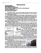
Managing coastal erosion, Holderness
Coasts-Case studies Managing coastal erosion, Holderness The Holderness coast lies between Flamborough Head and Spurn Head and is one of the fastest eroding coastlines in Europe. The average rate of erosion is 2 metres per year. Over 30 villages and 26 towns have fallen into the sea since roman times. There are lots of erosion features along the Holderness coast. The coastline is made of soft clay which experiences rapid erosion. In addition, longshore drift moves south along the coastline so there is little opportunity for beaches to become established in front of the cliffs The erosional landforms evident along the coastline are varied. There is a wave-cut notch and a wave cut platform at Flamborough Head. Flamborough Head is a headland and along the same coastline are caves, arches and stacks. Towns and villages are constantly under threat from the sea. The coast needs to be managed to protect the settlements. During the cource Hornsea Hornsea is a town on the Holderness coastline that has nearly 3km of shoreline fronting the town. The coastline's position has been fixed since the coastal defences were put up which was in 1990s. A concrete sea wall protects the town from flooding. Groynes ensure that the sand and shingle beach is not washed away by long shore drift. Mappleton Mappleton is a village 3km south of Hornsea. The village has been exposed to rapid
In the British Isles Coastal Areas Have Always Attracted Settlement.
In the British Isles coastal areas have always attracted settlement. People come for a holiday or they might have a second home by the sea. Many retired people also live near the sea, seeking a quiet and refreshing place to spend the rest of their lives. Tourism has also spread up the coastline bringing more people and so more resources have been set up to accommodate them. Pathways have been built along the coast to bring easy access to the tourists. However, along Britain's coasts, erosion is taking place which potentially destroys cliffs, houses and moves beaches. Coasts are managed to keep the sea out and to keep the beach in. In 1990, Mappleton was under threat from losing 30 houses along the coast of Holderness. Its main road would've disappeared into the sea and would be very expensive to rebuild. So, a coastal management scheme was set up. Blocks of granite were imported from Norway so two groynes could be built. This would trap the beach sediment that is being eroded away due to longshore drift. This would then absorb some of the energy from the waves so less energy would be directed on the cliff's side. This would reduce erosion. Many people thought that Mappleton should just be allowed to disappear into the sea, however it is very difficult to express this. Groynes are very expensive to make and last for approximately ten years. Even though these can look ugly, the
My pilot study and extended investigation is to be conducted at Hunt's Bay, Gower.
INTRODUCTION My pilot study and extended investigation is to be conducted at Hunt's Bay, Gower. Hunt's Bay or Deep Slade is situated on the Gower Peninsula facing south. The OS (ordinance survey) grid reference of hunt's bay, from a mumbles and south Gower map is 564 868 (see appendix 1). It is a rocky beach. The rocks are made up of carboniferous limestone, a sedimentary rock. We decided that the bedding planes at Hunt's Bay are about 45 degrees from each other, with smooth fronts due to erosion by the sea. This will affect the type and amount of sea life at the beach. Cliff face Sea 45 degrees Aim of Pilot study The aim of my pilot study is to conduct a transect of Hunt's Bay. From this, I will be able to produce a zonation pattern for the beach, draw a profile of the beach, calculate the exposure rating and discuss the distribution of various organisms found on the beach. This will help me with my extended investigation. Method for conducting a transect at Hunt's Bay The method I am going to use to conduct a transect at Hunt's Bay is the Cross-Staff method. (Refer to appendix 2) Tides A tide is a periodic rise and fall of all ocean waters, including those of open sea, gulfs and bays. The tide will rise and fall twice approximately every 25 hours, giving two high tides and two low tides daily. Tides are the result from the

Is there a problem of costal management at Porlock Bay?
Aim - Is there a problem of costal management at Porlock Bay? Many coastlines in MEDC's and LEDC's are heavily populated. The coasts provide many people high with income from tourism and leisure activities. Some coastlines also have a high economic and land value. Coastlines are sometimes prone to flooding or erosion from costal processes. Coastlines are fragile natural environments, which are easily damaged by the whether and people. If they are destroyed, the ecosystems can take a long time to recover from the devastation. Flooding is s problem at Porlock Bay; this is shown in the salt marsh that has formed from flooding in between Gore Point and Hulstone Point. This area is shown where the arrows are pointing How would costal protection systems be suited for Porlock Bay? Groynes The groynes can be made of wood, steel or rock. The groynes are supposed to protect the beach by creating a barrier. This will stop the beach material being moved by long shore drift. There is a groyne barrier at Gore Point, which is used to protect the boats passage out of Gore Point. The advantage of this costal protection is that the groynes will keep the material in the bay. The disadvantage of using groynes is that it is high maintenance and the groynes are very unattractive. This type of protection costs roughly £340,000 per kilometre. The groyne at Gore Point is shown below -
"What management is there at Freshwater Bay and how effective is it?"
Introduction to the Investigation The purpose of this investigation is to test the following research question: "What management is there at Freshwater Bay and how effective is it?" Fundamentally this means that I am going to study the area of Freshwater Bay then test and examine what positive or negative effects the management has on the area. My research and findings are going to test the question to find an answer. In order for me to answer this question I am going to break it down into two main sections: * In what way does management of the bay change it from east to west? In this study I am going to examine how the management schemes are effecting the beach, and in what ways it its doing this. * What is the main land use behind the bay and how is management protecting it? In this study I am going to examine the land use at Freshwater Bay and see what the management is being used to protect. Location Location of the area: The Isle of Wight is and island 380km², and is situated off the southern coast of England in the English Channel. The island itself is represented as one of the counties of England and has a population of 111,300 people. Freshwater Bay is situated on the South East coast of the Isle of Wight. The A3055 is the main road that runs along the west cliff top and down through the Freshwater area. Methodology The information that I require for
Describe and examine the landforms that are produced as a result of costal deposition in an area you have studied.
`Describe and examine the landforms that are produced as a result of costal deposition in an area you have studied. Deposition is defined as 'the laying down of sediments, produced by weathering and erosion of landmasses...'. Deposition occurs when velocity decreases and therefore suspended sediment can no longer be transported. There are four main landforms that are resulting form landforms, beaches, spits and tombolos, forelands and barrier islands. The area that I have studied is the Vale of Glamorgan Coastline form Merthyr Mawr Warren to Breaksea Point and within this area there are many depositional features. Most of the rock in the area was formed during the Jurassic period approximately 150 million years ago. Most of the rock formed in this period was limestone and shale. Lias is the most commonly found shale in this area, a soft, reddish coloured rock. Beaches are the most common of the four depositional features. They are created by deposited material from breaking waves; the constructive action is mainly effected by the swash. The swash is the turbulent mass of water, which flows up the beach following the breaking of a wave. The swash contains much of the suspended sediment, and this sediment is then deposited upon the beach. In the area that I have studied there are many sandy beaches and two good examples of this are Dunraven Bay, and Traeth Mawr Beach. Both
The Holderness Coastline is located near East Riding of Yorkshire. The coastline is Europe's fastest eroding coastline. This case study will explain the process and effects of the erosion taking place
Holderness Case Study Case Study Questions Who is affected by the erosion? What is being done to manage the coast? Where are the effects of management and where is the erosion taking place? Why is the coast being eroded? When does the most erosion take place? How do human effect the erosion? The Holderness Coastline is located near East Riding of Yorkshire. The coastline is Europe's fastest eroding coastline. This case study will explain the process and effects of the erosion taking place and the coastal management decisions. The Holderness coast stretches over 60 km and supports many homes and towns. Over the last 2000 years the coast has retreated 400m and continues to do so at a speedy speed. The retreat caused over 30 villages since Roman times, to have fallen into the sea. The average rate of retreat calculated is 1.8m per year. Many people along the coastline are affected due to the rapid retreat of the land. Many of their property are threatened, and some of the people are not guaranteed that their area will be protected. The Holderness coast used to be covered with glacier sheets. When it defrosted, it left materials that are very soft and contain rich soil which makes it easy to erode. The two main rocks are chalk and boulder clay, the clay cliffs on the south are easily eroded compared to the more resistance chalk who were less affected by the destructive

To what extent do you agree with the view that coastal systems are too complex to ever be completely manageable?
To what extent do you agree with the view that coastal systems are too complex to ever be completely manageable? Of all the earth's natural environments, the coast is the most rapidly changing and dynamic. It can be defined in several ways, but at its simplest, it is the place where land and sea meet and interact. The coast is under numerous pressures due to its pull for economic activity, settlement, recreation and wildlife. Its form is greatly influenced by Terrestrial (Weathering, erosion, deposition, rock type/structure). Human (Pollution, recreation, settlement, defenses) and Atmospheric (Climate. Marine, Waves, tides, salt spray). They all interact to produce the enormous variety of coastlines found worldwide. (From beaches and cliffs to coral reefs). As things like coastal tourism have become more frequent, humans have found it increasingly necessary to attempt to control the effects of the sea. The main reasons for coastal management are to protect the coast from the erosive effects of the sea and to increase the amount of sand on the beach. Many strategies have been tried around the world, and these can be divided into two main groups, hard and soft engineering. Hard engineering methods aim to stop the coastal processes from occurring. Soft engineering methods try to work with nature to protect the coast. Coastal lands and sediments are constantly in motion.
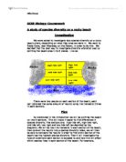
A study of species diversity on a rocky beach
GCSE Biology: Coursework A study of species diversity on a rocky beach Investigation We were asked to investigate how species diversity on a rocky beach alters, depending on what tidal area we were in. We went to Brady Cove, near Swansea, on the Gower, in order to do this. We decided that the best way to investigate diversity alteration was by splitting the beach area in to 6 pieces. Like so: There were two people on each section of the beach, each pair obtained the same amount of results using line transects (three in each section). Plan As mentioned in the introduction we will be splitting the beach up into 6 sections. This will make it easier to find differences in species diversity. The sections are: high tide left, high tide right, mid tide left, low right and low tide left (as depicted by the diagram). We will do two line transects in each section of the beach, then convert the results into a species diversity index, we will then be able to compare the results in order to find which section of the beach has the highest species diversity. Then I will investigate the type of conditions each section is exposed to and how this will affect which species lives in each section of the beach. For example, whether the section is shielded from rain, reached by the tide, or if it is exposed to sunlight for long periods of time. This could affect the different sorts of


