
Find out why there is no Carboniferous Limestone visible around the Somerset area.
A2 Extended Coursework Contents Contents 1 Introduction 2 Background Information 2 Planning 7 Desktop Investigation 7 Methods of Analysis 7 Fieldtrip Planning 8 Measuring the Height of the Cliffs 8 Collecting Mudstone to determine CaCO3 8 Look at the ORS at the Quarry on the Quantocks 8 General Equipment Used for Collecting Other Data 9 Lab Work Planning 9 Possible Errors and Limitations 9 Health and Safety Issues 10 Fieldtrip Hazards 10 Lab Work Hazards 11 The Fieldtrip 12 Measuring the Height of the Cliffs 12 Collecting Mudstone to determine CaCO3 13 General Equipment Used for Collecting Other Data 14 Rock Measurements 15 Lab Work 16 Introduction 16 Method 16 Rock Sample 16 Control 17 Calcium carbonate content 17 Results 17 Rock Sample- Before 17 Rock Sample- After 18 Control- Before 18 CaCO3 Sample- After 18 Conclusion 18 Hypotheses Proved/Disproved 20 No Limestone Deposited At All 20 Limestone deposited then eroded to nothing. 21 Limestone deposited and then folded and faulted below the surface. 23 Limestone has been overlaid by other Rocks. 24 Human Activities have removed all the Limestone. 24 Combination of the Above 25 Conclusion 25 Evaluation 26 Errors and Solutions next time in the Collection of the Data 26 Improvements and Add-ons to this Investigation 28 Acknowledgements 29 Bibliography 29 Appendix

Porosity and permeability.
Porosity and permeability coursework The vast majority of geological materials can hold water to a greater or lesser extent, the amount of water if affected by the materials porosity and permeability. Porosity is a parameter that describes the amount of open space in geologic material, it can be stated as either a fractional value or percentage of the material that is open space. This open space is not however a void like the interior of a balloon it is more like a sponge with small air bubbles and interconnecting pores. These open pore spaces occur between sediment grains, in cracks or fractures and also on a larger scale in cavernous openings formed by dissolution of rock. The porosity values of rock typically range from 0-50%, this space is often filled with water or air or mixture of both. Permeability is closely linked to porosity as permeability is a parameter that describes the ability of geological material to transmit water. Permeability is measured in Millidarcy (MD) or Darcies (D). A Millidarcy is 1/1000 of a Darcy. A Darcy is the permeability that will allow a flow of 1 cubic centimetre per second of a fluid with 1 centipoise viscosity through a distance of 1 centimetre through an area of 1 square centimetre under a differential pressure of 1 atmosphere. The greater the permeability of a rock, the easier it is for fluids to flow through it. Typical permeability

Rock Collection Science
Sonja Radmilovic Rock Collection Science 9-1 27/4/02 Rocks are composed primarily of minerals and can be an amalgam of different minerals or can be composed of one mineral. Over 3500 minerals have been identified; most of these can be found in the earth's crust. Some of the earth's minerals are exceedingly popular - fewer than 20 minerals compose more than 95% of the earth's crust. There are three different ways rock can be created on earth and thus there are three main classifications of rock, based on the three processes - igneous, sedimentary, and metamorphic. The rock cycle represents the alteration of rock-forming minerals above and below the earth's surface. At the top of the diagram molten rock material, magma, cools (crystallization) to form igneous rocks. If magma is extruded on to the surface it is called lava. Cooling above the surface yields rocks with fine textures, while those that form from slow cooling beneath the surface typically have large crystals. Igneous rock may melt when exposed intense heat to form magma again, or be changed into metamorphic rock. Igneous rocks may also be exposed to weathering, erosion and deposition to form sediment, the precursor for sedimentary rock. As sediments accumulate they are subjected to compaction and cementation to form

'I think that sedimentary stones will be more affected by weathering than igneous stones.' - discuss
Page 1 H.Crawford 5/7/2007 Introduction Hypothesis: 'I think that sedimentary stones will be more affected by weathering than igneous stones.' Whilst this is what I setting out to explore and hopefully prove, I also hope to prove that the front side of the gravestones will, in general, be less weathered than the backs of the graves. I think this because most people want the front side of their grave to be less weathered and so they design the grave so that the front side will be less affected by weathering (e.g. by facing the grave east, because most of England's weather comes from the West with the North Atlantic Drift.) Pilot Study: There are many reasons for my pilot study, the main one being that I wanted to check that everything worked. This included: - To see if there were enough stones of each type, for without enough stones of each type I would have been forced to change my hypothesis for the sample size would not have been large enough for it to have been conclusive. Fortunately there were enough. - Furthermore to see if there were enough stones from different dates; or, more to the point, to check there were enough stones of the two different types with similar ages; which there were just about, although I did notice that there seemed considerably more sedimentary stones in the 19th Century than in the 20th. I researched this on the web and

Determining the paleoenviroment and tectonic history of a small area (Cocklawburn Beach)
Geology Coursework Jonathan Robinson Geology Coursework: Determining the paleoenviroment and tectonic history of a small area (Cocklawburn Beach) Planning In this coursework I am going to try and find the tectonic history and paleoenviroment of an area of exposed rocks along a short section of beach in Northumberland, Cocklawburn beach is 50 metres to the south of Berwick-upon-tweed and can be found on OS map sheet 75. The general geology of the area is that it is mostly carboniferous limestone with layers of sandstone, shale and coal existing between the layers of limestone. I know this from previous experience in the area, as I have completed a sedimentary log for another section of rock in the same area, at Cullernose Point For the paleoenviroment I am going to look at and analyse the rock type.. I will check the rocks for structures and fossils as they can be used to determine the absolute age of the rocks and they can also be used to check if the rocks have been shifted or if they have been moved upside down. The first thing that I shall investigate with respect to paleoenviroment is the relative age of the rocks. For the tectonic history I shall investigate the Dip and Strike of the rocks, as this will show the attitude of the rocks relative to the horizon and it will show if any tectonic activity has shifted the rocks, and also if there are any major igneous

In this Essay I will inform you of the social, economic and environmental advantages/ disadvantages which relate to the activity and outcomes of the Limestone Industry.
5th Oct 03 Science Essay-The Limestone Industry In this Essay I will inform you of the social, economic and environmental advantages/ disadvantages which relate to the activity and outcomes of the Limestone Industry. Firstly is shall answer the highly common and simple question; 'Why bother Having this industry?' Look around you. The house your siting in, warm and cosy wouldn't be standing if it wasn't for the limestone industry, in fact buildings as strong and durable as these are wouldn't exist. Finding it hard to read this essay? A little bit short sighted perhaps? Then get out you reading specs that they themselves, wouldn't exist if the limestone industry didn't. I like the new car you've got out side, im sure that if the limestone industry didn't exist neither would your car because steel manufacturing to make the car would be too expensive. Hungry? Then swipe some of the millions of fresh and delicious vegetables from the local supermarket that wouldn't be so cheap let alone delicious if the limestone industry didn't exist. In fact without this industry there would be no fertile farming land, so farming wouldn't exist. Foundations and cement for buildings, statues, pavements and roads couldn't be made to the cheapest and highest standard and strengths they are now, the sea wave barriers couldn't be produced to prevent erosion against the coasts. Glass

Construct two Graphic Log Sections, one on the eastern exposure (ST 3375 6645) and one at the western exposure (ST 3245 6605) of the Carboniferous Limestones and volcanic rock exposed in the low, coastal cliffs - compare the two.
Contents -Introduction............1 -Data Collection............2 -Log Graphs............2a -Analysis (Location 1) ............3 -Analysis (Location 2) ............4 -Conclusion............8 -Evaluation............10 -Bibliography............8 Geology Bath and Bristol Coursework Introduction From the 1st-4th July we studied a geological area based around parts of Somerset, around Bath and Bristol areas. One specific site that we studied was Sand Bay, north of Weston-Super-Mere, (ST 3305 6596, which is located on the map above. The purpose of this investigation was to construct two Graphic Log Sections, one on the eastern exposure (ST 3375 6645) and one at the western exposure (ST 3245 6605) of the Carboniferous Limestones and volcanic rock exposed in the low, coastal cliffs. Then to compare the two graphic logs (similarities and differences) and interpret the geological condtions that led to the formation of the sequences observed. In South Wales and the South-West of England in the Lower Carboniferous times, several hundreds of metres of limestone and calcareous mudstones passed southwards into a deformed sequence. A shallow south sea in the north bordered a deeper marine area to the south that revealed limited supplies of course sediment, in which was some volcanic activity. Data Collection We collected data from two locations. We had to predict if there was
What Really Happened at Pompeii on 24th August AD79?
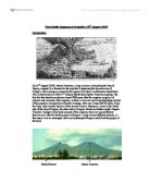
What Really Happened at Pompeii on 24th August AD79? Introduction On 24th August AD79, Mount Vesuvius, a large volcano overlooking the Bay of Naples, erupted. It is famous for the way that it destroyed the Roman town of Pompeii, and in doing so, preserved the agony of Pompeii's unfortunate inhabitants. This is shown above in this 17th century sketch showing the Vesuvius erupting. The fact that this sketch was drawn almost 2000 years after the eruption is typical of pictures and accounts of the eruption, as there is only one surviving first-hand account of the eruption, coming from Pliny the Younger, who was living with his uncle, Pliny the Elder, who was the admiral of the Roman Fleet at Misenum, a town at the North side of the Bay of Naples, the other side to Pompeii which was further south. Despite Pliny the Younger's first hand account of the eruption, there are many different theories as to what killed the people of Pompeii. Using various different sources, in this essay I aim to investigate what really destroyed Pompeii and killed the people of the town. Monte Somma Mount Vesuvius This picture shows the view of Mount Vesuvius from Naples. This is roughly the view that Pliny the Younger would have got when viewing the Vesuvius erupting. From the view in the picture above, Pompeii would be on the other side of the mountain. Monte

Gullet Quarry- Igneous Investigation.
Gullet Quarry- Igneous Investigation. Investigation. : To study the igneous intrusions at Gullet Quarry Aims : . To investigate whether the intrusions are of the same age. 2. To investigate whether the intrusions are the same type. 3. To investigate whether they are all from the same magma source. 4. To determine a sequence of events in the igneous section of the quarry. Plan : To carry out this investigation I will need the following equipment: hand lens, geologists hammer, crystal size card, ruler, tape measure, clinometer, penknife and a streak plate. In collecting the data to carry out this investigation I am proposing all the evidence will be uniform and will conform with the igneous work I have learnt in class. If there are any anomalous results in my data I will do my best to fit the anomalous result into my work. The evidence I am looking for is as follows:- . Crystal size. Crystal size is an important variable in determining the origin of the igneous rocks. The crystal size depends on how deep the rock was when it was formed. Finer crystals indicate that the rocks were cooled at a rapid rate i.e. near the surface of the earth. The larger the crystals are the slower the crystals were formed. Larger crystals show that the rocks were formed deep into the earth's mantle. To investigate crystal size I will need a hand lens, a crystal size card and a ruler. To

A Geological Report on the Permo-Triassic of Chester.
A Geological Report on the Permo-Triassic of Chester. Hypothesis: * The geology of Chester is dominated by sediments of desert origin and of permo-triassic age. Aims: * Investigate the rocks of the South Chester area; * Determine the depositional environment in which these rocks accumulated; * Determine whether or not the area was dominated by a desert environment in the geological past. Background Chester is located in the North West of England. It is not just a world-famous heritage city with 2,000 years of history dating from the Roman invasion of Britain; it's also the gateway to some of the finest countryside in England and neighbouring north Wales. The district of Chester stretches from the Dee estuary in the north to Shropshire's rolling hills in the south. To the west of the city are the stunning Welsh borderlands. East of this county town are the immense flatlands of the Cheshire Plain, carved out of the landscape by Ice Age glaciers with a history older than Chester itself. Here a host of timeless towns and villages with their traditional black and white, half-timbered architecture set amid green meadows and scenery - a vision of England as it was and still is. Introduction. The investigation will involve the reviewing of the depositional environments of sedimentary rocks and in particular the characteristics of desert sandstones. To determine the