Epping Forest Coursework
GEOGRAPHY COURSEWORK CARL RENDORA VISITOR IMPACT ON EPPING FOREST Contents Page 3 Introduction, Location & History Page 4 Map of Epping Page 5 Methodology Page 6 Methodology -&Questions I want to answer Page 7 Questions I want to answer (cont.) & Hypothesis Page 8 Data Limitations Page 9 Raw Data Page 10 Analysis and Data Presentation Page 11 Analysis and Data Presentation Page 12 Analysis and Data Presentation Page 13 Analysis and Data Presentation Page 16 Analysis and Data Presentation, Conclusion & Evaluation Visitor Impact on Epping Forest Introduction The purpose of this coursework is to find out about the impact which visitors have had on Epping Forest. Epping Forest has recreational, aesthetic and educational values, so is a perfect place for visitors. I feel that considerable damage has probably been caused to the environment due to the large number of visitors, and it is with this coursework where I will try to find out whether I am right. After analysis of my results I will also try to find ways in which any problems can be solved and bad situation can be improved. Aims: To find out: what attracts people to Epping Forest? ,what activities do people do in Epping Forest? ,what impact do visitors have on the environment? ,how well Epping Forest is being managed? The Location Epping Forest is located just north of London. It

Managing Road Traffic in Singapore
To manage the traffic flow in Singapore such that it flows smoothly without traffic jams which could result in loss of man-hours which could then result in higher productivity costs, the Singapore government has inplemented measures to manage the traffic flow. Some these are the Area Licensing Scheme (ALS), Electronic Road Pricing (ERP), and the Park and Ride Scheme. The Park-and-Ride Scheme is aimed at controlling the traffic flow in the CBD area. Motorists had to park their vehicles at designated car parks outside the city area. They had the option to take public transport into the city which were mostly located near the car parks. However, the Park and Ride Scheme was not very successful. This can be shown through the 585 parking lots used out of the 7700 created, which clearly shows that most people would enter the CBD area early or just take public transport.This also shows that the Park and Ride Scheme was not very popular amongst the people. Most drivers found it not worthwhile to leave their vehicle parked outside the city and pay for the parking fees. Overall, this meant that there were still traffic congestion within the CBD area thus meaning that the Park and Ride Scheme was not very successful in controlling traffic flow in Singapore. The Area Licensing Scheme (ALS), is also used to control the traffic flow in the CBD. Motorists have to pay for the use of certain

Changes in Guilford's Central Business District from 1968 to 2002.
Changes in Guilford's Central Business District from 1968 to 2002 Aim The changes of many aspects of a CBD from the 1960s to the beginning of the 21st century had been immense, the changes nevertheless is an important feature of human geography that needs to be carefully studied. In order to achieve my aim I will have to identify the changes in land use from 1968-2002 in the CBD of Guildford and also compare the changes that had been made over the time. I will locate the areas with high and low pedestrian counts, and also the areas of high and low land value, both of which would give me a better overview of the CBD area. It will be equally important to identify zones of recent assimilation and discard to identify the changes. An investigation on the future changes of the CBD of Guildford would also be helpful to reach a higher degree of the understanding of the CBD and to explain the changes as our world today is advancing at an extraordinary pace in recent decays in many areas that already have, and definitely will cause great impacts on our lives. Guildford The understanding of Guildford's economical structure would help us to explain the changes of the CBD since structure of any CBD is largely affected by the local economy. Statistics has shown that the economy of Guildford is relatively good compared to other cities of similar size, Guildford has an area of 104 squared
Migration within a countrys borders have greater negative impacts at their origin than their destination. Discuss.
“Migration within a country’s borders have greater negative impacts at their origin than their destination”. Discuss the statement [15 marks] Introduction . Definition of migration and internal migration 2. Reasons why people move (Push/Pull Factors) . Explain Lee’s migration model . Types of Internal Migration (Inter-urban, Intra-urban, counter urbanisation, urbanisation) Body . Social. Economic. Environmental. Political. (S.E.E.P.) impacts 2. Case Study (Statistics) . China (urbanisation) 2. London to St. Ives (counter urbanisation) . Negative impacts at origin 2. Negative impacts at destination 3. Recognize that there are also positive impacts Conclusion . Which one is the greater impact, origin or destination 2. Solution (brief) ______________________________________________________ Migration is the movement of people to establish a new permanent place of residence. The UN defines ‘permanent’ as a movement of over a year. Internal migration is the permanent relocation of population within a country. People choose or are forced to migrate due to reasons; these are called push and pull factors. Push factors are negative conditions at the point of origin, which encourages people to move, such as war, famine and natural disaster. Pull factors are positive conditions at the point of destination, which encourages people to move, such as better

I am studying both the positive and negative impacts of tourism on the Lake District
GCSE Geography Geographical Investigation What are the impacts of tourism in a selected region of the UK? Tourism is the industry that looks after the needs and welfare of tourists and provides the things that help them travel to places where they can relax and enjoy themselves. I am studying both the positive and negative impacts of tourism on the Lake District because the Lake District is being overwhelmed with tourists each year but without the income that tourism generates the Lake District wouldn't survive. The Lake District is one of 15 National Parks across the UK which has 2 main purposes. - To enhance and preserve the natural beauty of the landscape. - To provide a place for recreation and enjoyment. A third aim is; - To protect the social and economic well being of people who live and/or work in the National Park. The positive impacts of tourism are associated with the economy and employment. Tourism can also start off a cycle known as the positive multiplier effect; the tourism industry locates in an area which provides jobs for locals. This gives workers more money to spend and so more local shops open and more jobs are created and so on and so on. But as well as positive impacts, there are also many negative impacts of tourism. The first is footpath erosion. This occurs when people (tourists in this case) are

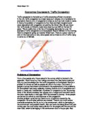
Pedestrian Counts.
GCSE Geography Coursework Analysis . Pedestrian Counts My Isoline Map of Cambridge shows that, as I predicted, the overall trend of my data is that the further you move away from the city, the fewer the number of pedestrians. This theory is backed up by my scatter graph, which shows a negative correlation meaning that the pedestrian counts and the distance away from the city centre are inversely proportional, with lower counts the further you move away. The two innermost, red coloured zones of the map have pedestrian counts in the mid four hundreds. These counts are this high for a number of reasons. They are in the centre of Cambridge's CBD, and as a result are filled with high demand shops and services, and a large number of densely populated office blocks. For instance the reading recorded on Market road, showing 419 people passing that point in ten minutes was most probably due to the famous 'Cambridge Market' which lies there. The highest reading of 465 on the corner of St Andrews street was again due to the presence of a great many shops and services. I also note that the time when these readings were taken is also important. The fact that they were taken at 11:30am on a Wednesday morning is crucial as this would be one of the times where the highest density of people would be shopping and working in offices. If these readings had been taken at 11:30am on a Sunday
Lognor Case Study
Longnor Longnor is a village in Staffordshire, 35 miles of SE Manchester. It has a population of 350 people and is in the Peak District National Park. It has numerous problems such as shortages of work, affordable housing and poor access to services. With the village of Longnor lying on the edge of the Peak District National Park, it attracts many tourists and holiday makers. These tourists and visitors travel long distances to visit the national park and need to stay somewhere when they arrive. There are no hotels in the village and very few bed and breakfasts, so one of the main sources of accommodation are holiday cottage rentals. Families and homeowners have second homes in Longnor, often which they rent out and visit. With many of the houses in Longnor being brought as holiday homes, second homes or retirement homes, there is a distinct lack of housing for the local people. As Longnor is within a commuting distance for Manchester and the houses are much cheaper than Manchester, villages like Longnor are attracting more and more YUPPIES and commuters. Also villages like Longnor are attractive to retirees as they are quiet and peaceful, they have places to walk and relax with lots of open spaces and greenery and clean air. They are far enough out of busy cities and younger generations but are within distance of local towns. With so many commuters and retirees buying

Case Study: Gambias Youthful Population. What are the positive and negative impacts?
Case Study: Gambia's Youthful Population Gambia is located in West Africa as shown by the map below. It is a small country of only 11,000km². Why is Gambia's population youthful? As Gambia is an LEDC, they lack the funds to employ a vast amount of doctors to the area. This means that for every doctor, there are 14,536 patients meaning that the inhabitants don't receive much healthcare. This has contributed to a relatively short life expectancy of just 54 years for a man and 57 years for a woman. The lack of healthcare available has also meant that there is an extremely high infant mortality rate of 73 per 1000 people, even though it is lower than it has been in the past. As many children die at an early age, parents tend to have a large number of children to help with daily tasks, to bring a higher income to the family and to look after the parents when they reach ill health. Gambia has a high birth rate of 40 per 1000 people because of this and in 2003, the average fertility rate was 5.13. What are the positive and negative impacts? Due the high birth rate, falling infant mortality rate and improvements in the level of healthcare available, the population has been increasing rapidly. In fact, Gambia's population doubles every 28 years and in 2009, it is estimated to be around 1.7million people. 63.55% of the population is estimated to be aged below 25 years and only

Geography isle of dogs
Thomas Edwards Geography coursework Chapter 1- Introduction In my GCSE Geography I will investigate and discuss the following hypothesis: 'The urban regeneration on the Isle of Dogs, East London, has provided a successful model for sustainable development' The aims of this course to help me prove or disprove my hypothesis are: * What have been the changes to the community, employment, housing and environment? * Have the changes made been sustainable and benefited everyone? * Are there further improvements that can be made to the area? Keyword: I have chosen to include the following keyword as it is an integral part of my hypothesis. Sustainable development: is where development of the present and the future are taken into consideration when using natural resources in order to develop the environment. History of the London docklands: I am going to include information on the LDDC (London Docklands Development Corporation) and the Isle of Dogs when it was one of the most in the prosperous docks world. This information is to help me understand the changes made allowing me a greater knowledge of its redevelopment and sustainability factors. One of the main causes for the docklands decline was that the river Thames became increasingly silted and this caused problems for boats as increase in demand meant bigger boats where required to access the main dock, and

Land Use Change In Northampton!
Deepak Chandi LAND USE CHANGE IN NORTHAMPTON! PART 1 (a): Northampton is a large market town best known for its footwear and leather industries. The town has recently grown outwards to the east and west. Northampton is situated around the River Nene. INDUSTRY: Many of the old industrial sites are located with in the CBD. Companies like Latimer & Crick; Corn Merchants use to be located near South Bridge (Smiths Timber Yard use to be located at the bottom of Bridge Street. Padmore & Barnes, shoe manufacturers use to be located on St. James Road. I believe that these old industries were located in these areas mainly as a result of transport links. Smiths Timber Yard was located at the bottom of Bridge Street mainly because the River Nene flows around Bridge Street so therefore this would be an excellent means of transport for the Timber yard. Padmore & Barnes was located on St. James Rd mainly due to the fact that a railway line runs through the area leading to other parts of Northampton and eventually linking up to other parts of the country. Also, the River Nene runs through the St. James area so therefore again creating good means of transport. Many of the new industrial sites are located out of the town centre. Brackmills Industrial Estate is located off the Bedford Road A428. The Crow Lane developments are located near the Billing garden Centre. Also there is the