A Brief History of Snowdonia National Park
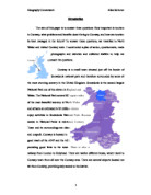
Contents Introduction 2 Method 6 Data Presentation 10 Data Interpretation 20 Evaluation 31 Bibliography 35 Introduction A Brief History of Snowdonia National Park Snowdonia National Park was established in 1951 and covers an area of 2,142 square kilometres (827 square miles). The park mainly consists of several ancient mountain ranges. These mountain ranges were formed by volcanic activity, and they were eroded during the Ice Ages. The highest of these is Yr Wyddfa Fawr (1,085m/3,560ft) one of the five peaks of the Snowdon Massif (or Mount Snowdon). Map 1.1 - Snowdonia National Park (The red square shows the location of Betws-y-Coed) There are many different roads leading into the park, which bring in visitors from other parts of the country. The A470 will bring in visitors from the South and South West ( and probably South Wales). The A55 and A543 will bring in visitors from the North, North West and North East (especially Liverpool, Manchester, Leeds and Sheffield). Map 1.2 - The area surrounding Snowdonia National Park Looking at Map 1.2, there are good transport links to the Park from other areas of the United Kingdom. For example, there is the M6 bringing in people from Manchester, Liverpool and Birmingham. The M4 brings in people from London and the surrounding area. What Is Tourism? Tourism is a multisectoral activity that requires

Investigate the attractions of Dawlish and the effects that tourism has on the town.
CONTENTS Page 1: Page 2: Page 3: Page 4: Page 5: Page 6: Page 7: Page 8: Page 9: Page 10: Page 11: Page 12: Page 13: Page 14: Page 15: Page 16: Page 17: Page 18: Page 19: Page 20: CHAPTER 1: INTRODUCTION The main aim of my enquiry is to investigate the attractions of Dawlish and the effects that tourism has on the town. Seaside resorts have different kinds of attractions, both physical and human, and the effects can be very varied. For example a physical attraction of Dawlish is the sandy beaches this effects the town in a mostly social way because it brings new people into the town, it also effects the town in an economical way because it mans that people spend money in the town raising it's economy. This area of Devon is quite seasonal and I think that the season effects the type of visitor for example in the summer families with younger children may visit where as in the spring older generations may take walks along the seaside, but the area can be enjoyed all year round. We choose to study this area of England for lots of reasons. It's close by so if anyone needs to go back to collect more information they don't have to travel a long way, because it close it means that most of us know a little about it anyway so it makes the research easier. We know the area is a tourist resort because we live close to it and therefore it fits the criteria of

Geography - Ivestigation of the River Colne, Buckinghamshire
25 Pages Introduction Pages 3-6 Hypotheses (at top of page): Page 3 Maps of Location of River: Page 4 3D map of river: Page 6 Methodology: Pages 6-8 Data Presentation: Page 8-19 Raw Data Table: Pages 8-9 Photos: Pages 10-14 Volume of flow: Proportional Line map: Page 15 Width, Depth, Velocity and Volume of Flow Graphs: Pages 16-17 Vegetation and Height Above Sea Level Graphs/Charts: Page 18 Differences in Height Above Sea Level Graph: Page 19 Data Analysis: Page 19-22 Hypothesis 1: Pages 19-20 Hypothesis 2: Pages 20-21 Hypothesis 3: Pages 21-22 Conclusion: Page 22 Evaluation: Pages 22-25 Final Conclusion: Page 25 Bibliography: Page 25 I formulated my hypotheses based on my current knowledge: * I expect the river to get wider and deeper as it flows downstream because it will be joined by tributaries, and other water e.g. from rainfall, so the volume of water in the river will increase, therefore the width and depth of the river must increase to accommodate this extra water. The extra water will also entail more hydraulic action, so the banks of the river will be eroded more, and more water also means more sediment. This sediment will also erode the banks more; rocks carried by saltation or traction will erode the bed, making the river deeper,

Shopping Coursework
Rebecca Millhouse There is a greater variety of shops on Chichester High Street than East Wittering High Street, so more people will travel further, but less often, to shop there. Introduction Ideas, Concepts and Processes During the month of August 2009, I collected the data for my geography coursework. As I was to be on holiday for the whole of my summer break I chose to investigate two locations near my holiday location, East Wittering High Street and Chichester High Street. I chose these two locations as they are suitably different whilst still being in a similar enough location that people will have heard of both. I chose to study Shopping, from the topic Settlement, as my Geography Coursework Topic, as I believe that shopping is changing. Less people go to the small village shops that are near them, instead travelling further to use large supermarkets or even buying their shopping online and having it delivered. Shopping is no longer a leisurely past time, instead it's become a chore and less and less people are spending their weekends at the shopping areas near them, but if they do go shopping, it becomes a great task involving a long travel, or great expense. My Hypothesis There is a greater variety of shops on Chichester High Street than East Wittering High Street, so more people will travel further, but less often, to shop there. This was then split into
Is Lytham a Honey-Pot?
Is Lytham a Honey-Pot? Introduction Aim The idea of my 'Geography Fieldwork' is to find out if Lytham is a 'honey pot' or not and to do this we have set certain hypotheses. These hypotheses are as follows: Lytham, * Attracts 'swarms' of visitors * Has attractive scenery * Has places of historic interest * Caters for people with more leisure time * Provides ample car parking space * Lies in close proximity to several self-catering caravan parks / holiday villages * Advertises in brochures, magazines and newspapers * Can provide hotel / guest house accommodation * Once people have visited Lytham they come back * People who visit Lytham are mainly over 50 years of age * Most people who visit Lytham are middle class * People visiting Lytham are mainly female * Has shops providing specialist or tourist commodities By finding answers to the hypotheses above I should be able to give a more accurate statement to say that Lytham is a honey pot. I also need to try and find out if the visitors create: * Parking problems * Traffic congestion * Crowding * Litter Are the four above statements True or are they False? Method Below is a simple timetable for the investigation: (a.m.) * Note down types of businesses and shops in Lytham town centre on a street map. * Conduct a traffic survey (5 minutes). * Conduct a pedestrian survey (10 minutes). *

Cliff erosion in East Sussex - the processes, problems and solutions.
Index Introduction page 3 Summary of Coastal Erosion and Weathering page 4 Rottingdean page 5 Peacehaven page 7 Newhaven West page 9 Newhaven East page 11 Cliff Retreat rates page 13 Problems of Cliff Retreat page17 Solutions for Coastal Erosion page 19 Cost Benefit Analysis page 23 Questionnaire page 24 Questionnaire Results page 25 Questionnaire Analysis page 26 My solutions for the sites page 27 Lewes

The aim of this project is to delimit the CBD of Stamford.
Geography Coursework Geography Coursework Abstract The aim of this project is to delimit the CBD of Stamford. The CBD is the central business district of a town in which are found most of the offices and shops. The group that aimed to find the borders of the town was a group of Rugby School pupils. This group collected the Data and in this booklet is discussed the relevancies of the information, why trends in the data have been found and how these trends could be used to find and Delimit the CBD of Stamford. This delimitation is done in the conclusions section. Finally in the Evaluation problems with the project are discussed and how it could be improved if the investigation were to be repeated. Table of Contents Abstracts..........................................................................2 Table of Contents................................................................3 Table of Illustrations............................................................4 Acknowledgments................................................................5 Introduction.......................................................................6 Methodology.....................................................................8 Results........................................................................... 11 Analysis and
The aim of this paper is to answer three questions: How important is tourism in Conway, what problems and benefits does it bring to Conway, and how can tourism be best managed
Introduction The aim of this paper is to answer three questions: How important is tourism in Conway, what problems and benefits does it bring to Conway, and how can tourism be best managed in the future? To answer these questions, we travelled to North Wales and visited Conway town. I constructed a plan of action, questionnaire, made photographs and sketches and collected leaflets to help me approach the questions. Conway is a small town situated just off the border of Snowdonia national park and therefore surrounded by some of the most stunning scenery in the United Kingdom. Snowdonia is the second largest National Park out of the eleven in England and Wales. The National Park covers 832 square miles of the most beautiful scenery in North Wales and attracts an estimated 6-10 million visitors enjoy activities in Snowdonia National Park. Because access in National Parks is restricted, Conway Town and its surroundings are clean and unspoilt. Conway is located in good reach of the A547 and the A55, providing good links to the town. There is also a railway from London to Holyhead. There are twelve different buses, which travel to Conway town from all over the Conway area. There are several airports located not far from Conway, providing easy access to the district. I have drawn up a table to show airports close to Conway: Name of Airport Distance from Conway (km)

The aim of my coursework is based on investigating the shopping hierarchy and the C.B.D. (Central Business District) of the Royal Borough of Kingston with the aid of several hypotheses.
GCSE Geography Coursework http://www.latimerandco.com/area.html Investigating the shopping hierarchy of Kingston Town Centre Contents (pages) Introduction 3 - My hypotheses 5 - Background 7 Methodology 8 -Secondary information 9 -Primary information 11 -Pedestrian counts 14 -Shops in each street 14 -Problems & Difficulties 15 Data presentation & Interpretation 16 -Figure 1 16 -Figure 2 17 -Figure 3 18 -Figure 4 20 -Figure 5 21 -Figure 6 22 -Figure 7 23 -Figure 8 23 -Figure 9 25 -Figure 10 27 -My Photographs 28 Evaluation 31 Bibliography 32 Introduction The aim of my coursework is based on investigating the shopping hierarchy and the C.B.D. (Central Business District) of the Royal Borough of Kingston with the aid of several hypotheses. I chose to base my coursework on the Royal Borough of Kingston, mainly focusing on the Kingston town centre, as it is a familiar area that I visit frequently for shopping purposes. The Royal Borough of Kingston covers an area of 3,748 Ha with a population of 147,273 residents. Situated nearby the River Thames and just 12 miles South West of the centre of London, Kingston is well known as the most desirable shopping area for South West London and Surrey as well as being the 17th largest retail centre in the UK. Map of the
Analysis of sphere of influence in different shopping centres. Like Merry Hill and Kidderminster, Dudley has problems as well. The shops in Dudley are being closed down as many shoppers visit Merry Hill instead of Dudley resulting in a loss of businesses
Analysis Analysis 1 : Sphere of Influence From the car registration data, I can see that the settlement with the largest average distance travelled is Kidderminster (old), with 142.83km. This is followed by Dudley (131.10km). This is then followed by Merry Hill (111.312km). The settlement with the lowest average distance is therefore Kidderminster (new), with 93.44km. Most of the cars visiting Merry Hill came from Birmingham with 17 cars, followed by Worcester with 7 cars. Most of the cars visiting Kidderminster (old) came from Worcester with 9 cars, followed by Birmingham with 4 cars. Most of the cars visiting Kidderminster (new) came from Birmingham with 8 cars, followed by Worcester with 4 cars. Most of the cars visiting Dudley came from Worcester and Birmingham with a tie of 7 cars each, followed by Leeds with 3 cars. The furthest place that cars came from for Merry Hill was Dundee with 364.8 miles. The furthest place that cars came from for Kidderminster (old) was Keith with 482.5 miles. The furthest place that cars came from for Dudley was Glasgow with 286.9 miles. The furthest place that cars travelled from for Kidderminster (new) was Glasgow with 296.2 miles. There are no anomalies for Merry Hill. There is one anomaly for Kidderminster (new) and that is Glasgow. There is one anomaly for Dudley and that is Glasgow. There is one anomaly for Kidderminster (old) and that