-
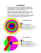
Zone I: Central Business District (CBD) where most of the tertiary employment is located and where the urban transport infrastructure is converging, making this zone the most accessible. It would contain all of the shops and offices and was known to be the centre of attention of the town.
-
Zone II: Immediately adjacent to the CBD a zone where many industrial activities locate to take advantage of nearby labor and markets. Further, most transport terminals, namely port sites and railyards, are located adjacent to the central area. People living in the upper-class rural urban fringe would have to come by rail each day due to the distance of their housing from the CBD.
-
Zone III: This zone is gradually been reconverted to other uses by expanding manufacturing / industrial activities. It contains the poorest segment of the urban population, notably first generation immigrants living, in the lowest housing conditions. Being terraced housing in disrepair these areas due to the living standards and first generation immigrants would have a high rate of theft and crime.
-
Zone IV: Residential zone dominated by the working class and those who were able to move away from the previous zone (often second generation immigrants). This zone has the advantage of being located near the major zones of employment (I and II) and thus represents a low cost location for the working class. This would be a step above the previous the housing would still be of a low quality.
-
Zone V: Represents higher quality housing linked with longer commuting costs. This area would normally contain detached and semi detached housing. The streets are often avenues and cul-de-sacs.
-
Zone VI: Mainly high class and expensive housing in a rural, suburbanised setting. The commuting costs are the highest. Prior to mass diffusion of the automobile (1930s), most of these settlements were located next to rail stations. In these areas often, large department stores could also be found.
According to this model, a large city is divided in concentric zones with a tendency of each inner zone to expand in the other zone. Urban growth is thus a process of expansion and reconversion of land uses. For instance on this figure zone II (Factory zone) is expanding towards zone IV (Working class zone), creating a transition zone with reconversion of land use.
Although the Burgess model is simple and elegant, it has drawn numerous criticisms:
- The model is too simple and limited in historical and cultural applications up to the 1950s. It is a product of its time.
- The model was developed when American cities were growing very fast in demographic terms and when individual transportation was still uncommon. Expansion thus involved reconversion of land uses. This concept cannot be applied in a contemporary (second half to the 20th century) context where highways have enabled urban development to escape the reconversion process and settle in the suburbs.
- The model was developed for American cities and has limited applicability elsewhere. It has been demonstrated that pre-industrial cities, notably in Europe, did not at all followed the concentric circle model. For instance, in most pre-industrial cities, the centre was much more important than the periphery, notably in terms of social status.
- There were a lot of spatial differences in terms of ethnic, social and occupational status, while there were low occurrence of the functional differences in land use patterns. The concentric model assumed a spatial separation of place of work and place of residence, which was not the generalized until the twentieth century.
However, the Burgess model remains useful for approximation of concentric urban development and as a way to introduce the complexity of urban land use.
A Brief History of High Wycombe
Now that we have done the history of Burgess we must do the history of High Wycombe to see how it has progressed throughout the past and to see if the model of a “text book” relates to the real town.
High Wycombe was first granted a market charter in 1237 and prospered for centuries through its market trading and other rural industries such as lace-making, rush-weaving and small-scale furniture production. However, it was as an early centre of mass manufacturing that the town rose to real prominence. Mills powered by the River Wye and timber gathered from the woodlands of the Chilterns were used to produce items such as paper and furniture, the architectural evidence for this remains, and some, such as the cane and rush works in High Wycombe, are still in use.
The bulk of the District is covered by the Chiltern range of chalk hills, which rise to over 250 metres at Coombe Hill. The Vale of Aylesbury to the north is flat clay lands. The Chilterns provide much of the local vernacular building materials that characterise the District. However with chairmaking a particular speciality, as a result, High Wycombe rapidly evolved into the undisputed furniture capital of England, a position it held for two hundred years. At the height of its output in the 19th Century, 5000 chairs were being manufactured per day, a fact celebrated in 1880, when an arch consisting entirely of chairs was constructed, to commemorate a visit by the Prince of Wales.
Left: A picture of the famous arch made from 400 chairs in 1884 to represent the day that the prince of Wales visiting.
Right: A picture of the town in the 1930’s
Conclusion
After researching the Burgess land use model and the history in High Wycombe, it would seem to me that High Wycombe did not fit burgess’s land use model.
- First because the model is considerably out of date and would only be able to relate up to about the 1950’s. It was indeed a product of it’s time
- Land use was much more different 80 years ago when the model was created.
- It was not based on a small town such as High Wycombe it was based on large upcoming American cities such as Chicago. Chicago is much larger, has a massive increasing rate, is denser in population, is not a small scale town, and has a rapid revolutionising rate. We must also realise that this model was made just as Chicago was changing in demographic terms.
- Single use transport was not very common then, most people used public transport.
- It does not relate to High Wycombe because America’s cities origins are much different to those oh High Wycombe.
- The Burgess model does not account for certain geological factors that could alter the model such as rivers, which may alter settlement area or transport links.
- High Wycombe is situated in a valley, so this would almost certainly alter the towns layout and where housing would be placed, as well as transport be set up. The Burgess model does not cater for any of these abnormalities.
Now that I’m confident that the Burgess land use model does not fit the town of High Wycombe I will move onto the Hoyt land use model, and see if it may be able to fit into the layout of High Wycombe.