
I Remember When...
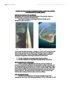
I Remember When... Daisy Donald 10F It was the first weekend in September. The summer holidays were over, and the schools had started back. I was on the beach for the first time after a long week at work. As Stratton was such a small Cornish town, there were very few people on the beach. My next-door neighbour and drinking partner, Hamish Pengelly was just leaving the beach after walking his dog, Graham Smith; the new owner of Stratton Manor was on the beach watching his son, Charlie, playing in a rubber dingy in the water. Also, Samantha Creeme, the mechanic for the nearest town, Bude, was on lifeguard duty. It was one of those pleasant days where it was warm, but quite windy. It had become slightly windier as the day approached mid afternoon, but it was bearable. I sat at the edge of the beach in my fleece reading a Dorothy Dunnet novel. I probably would have stayed in this position for the rest of the day, if it weren't for a faint shriek I could hear coming from the distance. I looked up from my book and I could see Charlie Smith, rapidly being dragged out by the current, waving his arms and the air and shouting recklessly for help. Stratton is famous for its currents. Only one person has died here in the past decade, but before the lifeguard system had been developed, the numbers were much higher. The strength of the current was due to the canal, which creates a
Report On the Change In Sediment Size Along the Length and Breadth of Hurst Beach.
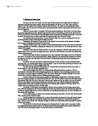
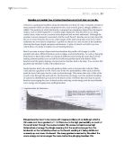
REPORT ON THE CHANGE IN SEDIMENT SIZE ALONG THE LENGTH AND BREADTH OF HURST BEACH IDENTIFICATION OF THE QUESTION Having spent a day collecting and collaborating data at Chesil Beach, Dorset we decided to make a comparison with Hurst Beach. Hurst Beach is a shingle, coastal deposit which has formed a spit on Hampshire's south coast (Fig. 2). This is much like Chesil Beach (Fig. 1), though on a smaller scale. Having examined Chesil Beach one factor that was observed was the change in the size of sediment laterally along the beach. Using our knowledge of longshore drift we decided to investigate two hypotheses concerning the sediments on Hurst Beach: ) The size of sediment increases laterally along Hurst Beach 2) The size of sediment on Hurst Beach increases further from the sea DEVELOPMENT OF A STRATEGY In able to answer our hypotheses the sediments on the spit needed to be sampled. It would be both unnecessary and unreasonable to sample every stone, and so a sampling strategy was developed. It was decided to sample the sediment in three places with increasing distance from the sea at lateral intervals of 100m. These 100m points had been marked out with posts during developments on the spit and so were simple to determine. The sediment samples would then be placed in plastic bags which would be carefully labelled to ensure minimum confusion. COLLECTION OF DATA The
A Midsummer Nights Death
A Midsummer Nights Death He was on his own. He waited, not very long. But how long would it take him? He looked up cautiously not knowing what to expect, what was he thinking? He was on a cliff face! What could he expect to see? The answer was of course nothing. Then it hit him. He couldn't see anything and neither could anyone else! He was on a cliff face but so was that homicidal maniac who knew he knew and could end it all right now. Dark rain clouds rolled in; Jonathan could hear thunder breaking on the horizon. He could sense a large storm approaching quickly. Maybe Hugo wouldn't have to do anything, as soon as the storm hit and the rain fell the small, not to mention frail, handgrips would be terrible for climbing of any type. It was now or never! He had to move or nature would take its course and take him off the cliff with it. His visibility was now very poor. As far as he knew Hugo was, could be, bearing down on him preparing to plant a huge climbing boot straight in his face! Fortunately for Jonathan, Hugo was still at the top and just as nervous as the paranoid Jonathan who was now completely motionless on the cliff face. The rope suddenly gave way; Jonathan's waist jolted backwards as soon as the strain was released. Jonathan grabbed out frantically, clasping onto whatever he laid his hands on. He finally got hold of a crag worthy of his weight. Jonathan's
Discuss the causes of desertification.
Desertification Desertification, term applied to land degradation in dry lands resulting mainly from adverse human impact. "Land" in these terms includes soil and local water resources, the land surface and vegetation or crops, while degradation implies a reduction of resource potential. Desertification has subsequently been recognized as one of a series of processes that affect dry lands all over the world. These processes include water erosion and wind erosion, as well as sedimentation by those agents, long-term reduction in the amount or diversity of natural vegetation, and salinization and sodication. Desertification was arguably the first environmental issue to be recognized as taking place on a global scale, a recognition that was formalized at the United Nations (UN) Conference on Desertification, held in Nairobi in 1977. CAUSES OVER GRAZING So-called "overgrazing" is a result of too much livestock being kept on a given area of pasture resulting in the loss of edible species and the consequent encouragement of inedible species. If excessive grazing pressure continues, the loss of vegetation cover can result in soil erosion. OVER CULTIVATION Other commonly quoted ways in which human mismanagement causes desertification include "over cultivation", in which soil is exhausted by nutrient loss and erosion, the excessive clearance of vegetation, often for fuel wood,

Hengistbury Head is located in the south of England and has many prevention processes to prevent cliff erosion such as groynes, gabions and revetments.
HENGISTBURY HEAD COURSEWORK INTRODUCTION Hengistbury Head is located in the south of England and has many prevention processes to prevent cliff erosion such as groynes, gabions and revetments. GROYNES: wooden or stone structures on a beach, built at right angles to the shore in order to trap sand and shingle moving by longshore drift. GABIONS: small boulders contained inside metal cages, placed at the foot of the cliff or along a beach to protect them from further erosion. REVETMENTS: Large boulders placed at the foot of the cliff, used to protect a cliff against further erosion by waves. THE AIM OF THE PROJECT The main aim of the project at Hengistbury head is to investigate the management of Hengistbury Head by doing investigations on the physical and natural changes in the surroundings. We are also investigating the erosion and damage of the beach and cliffs and investigating what is being done to prevent this. On the first day of the project at Hengistbury Head, we have to investigate the physical and natural changes to the beach and cliff landscape. We have to investigate the usage of the land at Hengistbury Head, and mention all the physical features and coastal defences that are present at Hengistbury Head. We must also note down all the human features present at the location such as management, archaeological sites, footpaths, car parks and cafes. We must also

Sheringham has an ideal example of what the coastline directly behind the sea is like both protected and unprotected, which contrast well.
IN PLACES WHERE THERE IS GREATER USE OF COASTAL PROTECTION, THE LAND BEHIND IT CAN BE USED TO GREATER EXTENT THAN THE LAND THAT IS PARTIALLY OR NOT PROTECTED AT ALL Contents Page Page Number Content Introduction 3 Method 4 Method - Pebble Sampling 5 Method - Clinometre 6 Method - Dumpy Level 7 Method - Wave Characteristics 8 Method - Transect Strip Map 9 Method - Different Types Of Coastal Protection 0 Method - Urban Work 1 Results - Wave Characteristics 2 Results - Pebble Sampling 4 Results - Transect Strip Map 5 Results - Clinometre 6 Results - Dump Level 7 Results - Tourist Facilities Count 8 Results - Questionnaire 20 Results - Traffic Survey 21 Results - Pedestrian Count 22 Conclusion 23 Evaluation 24 Glossary 25 Bibliography 25 Acknowledgments 26 Graph - Beach Profile (Dumpy Level) 27 Diagram - Calibrated Callipers 28 Diagram - Clinometre 29 Diagram - Dumpy Level 30 Diagram - Waterproof Tape 31 Diagram - Waves 32 Diagram - Long shore drift 33 Field sketch Looking East 34 Field sketch Looking West 35 Field sketch Of Groyne Introduction I went to Sheringham on the 17th of July 2002 to carry out the fieldwork for my geography coursework. I went to Sheringham, which is situated, on the north Norfolk coast. The grid reference is 160436. We went to Sheringham for various reasons and chose it over other
An Investigation On Comparison Of Two Beaches
An Investigation On Comparison Of Two Beaches In this investigation I am going to find out the geographical differences between Eype and West Bay Beaches. I want to study these Two Beaches because the Two are very different in lots of key ways and I want to know how. The Two beaches are located on the South coast of Dorset. (See fig 1). Both beaches are near to the town of Bridport. West Bay is situated approximately 1 Mile South of Bridport. Eype is about 2 miles Southwest of Bridport. (See fig 2 for map of area). (See fig 3 for satellite image of West Bay). Key Terms Wave Count This is where you count the amount of waves that come on to the beach in a certain amount of time. Cliff Height This is the distance from the highest point of the cliff to the ground. It is usually measured in meters. Longshore Drift This is where waves approach the coastline at an angle, which is not straight on, and material is moved along the coastline. Pebble Counts This is the amount of pebbles in a certain area over the beach. Wave Type There are two types of different waves. There is Constructive where there is a more powerful swash than backwash and there is also Destructive where there is a stronger backwash than swash. Tourism This is the amount of tourists that visit the to beaches and the effect they have on it. There are quite a few influences for this. Methodology This
"The Longest Day" "Saving Private Ryan" Write a study of how both films present the events of June
7th May 2002. Media Coursework "The Longest Day" "Saving Private Ryan" Write a study of how both films present the events of June 6th 1944. The two clips we saw didn't have the same things being shown in them or in other words, they were different. There's a major difference between the camera angles and camera and lens movements. The focus of the two clips are also different as the second clip, "Saving Private Ryan" focuses a bit more on the individual aspects and it showed more different emotions as compared to the other clip. And also the first clip was focusing more on the army as a whole and showed it as an open event. The two films are completely different in the form of their presentation; "Saving Private Ryan" looks more modern than "The Longest Day" seems to be. The length of events of the two films also differ as one seems to be longer than the other so this tells us one of the clips has more stuff in it. A lot of emotion and tension is shown in the two clips but you realise that, as the film goes on, more and more tension is built up. The landings seen in the two films is chaos of noise, mud, blood, vomit and death. There are scenes filled with countless unrelated pieces of time as it gradually goes on. The opening scene of the two movies is very graphic as any war footage. I am now beginning my commentary with "The Longest Day". This clip much

Tourism has impacted along the Hengistbury Head and Mudefort Split area. This has resulted in more costal problems.
Andrew Taylor Hengistbury Head Coursework Candidate Number 8383 Centre Number 58313 Contents Page Number Title 1 Title Page 2 Contents 3 Hypothesis 4 Method 5 Costal Protections 6 Erosion Problems 7 How Erosion Takes Place 8 Highcliff 9 Transect 0 Rubbish 1 Sketch Of Mudeford Spit 2 Hengistbury Head 3 Analysis 4 Analysis 5 Damage Done 16 Cost Vs Revenue 17 Conclusion 18 Evaluation 9 Picture 1 20 Picture 2 21 Picture 3 22 Picture 4 23 Picture 5 24 Picture 6 25 Picture 7 Hypothesis The hypothesis that my group have chosen to investigate is: "Tourism has impacted along the Hengistbury Head and Mudeford Spit area. This has resulted In more coastal problems." Throughout this piece of coursework, I will gather information from sources to either agree, or disagree with my chosen hypothesis. These are the areas that I will be investigating: * Tourist Facilities * Reasons why tourist facilities are needed * The coastal defences * Damage done to the coast - natural and human * Effects damage has done to the landscape * Cost Vs Revenue I am also going to be expanding this hypothesis by also investigating the impact that tourism has done to the Highcliff high street and Highcliff beach area. Method For this piece of coursework, need to gather information to either agree or disagree with my chosen hypothesis. I am going to gather
Beach profiling
Describe and explain how attached beaches vary in both plan and profile. A beach is a geological landform along the shoreline of a body of water. It usually consists of loose particles which are often composed of rock, such as sand, gravel, shingle, pebbles, or cobble. The particles of which the beach is composed can sometimes instead have biological origins, such as shell fragments or coralline algae fragments. Beaches often occur along coastal areas, where wave or current action deposits and reworks sediments. Although the seashore is most commonly associated with the word "beach", beaches are not only found by the sea or ocean: beaches also occur at the margin of the land along lakes and rivers where sediments are reworked or deposited. A profile of a beach is a cross section of the landform showing the shape, length, steepness and features. A plan of a beach is a bird's eye view which shows it's shape in relation to surrounding features. Beach can come in many shapes and sizes therefore the profile will change in width, gradient and show different features such as ridges, and storm beaches. As well as changing from beach to beach the profile can change at different points along the same beach. From looking at beach profiles you can tell that width and gradient tend to be linked. Wide beaches tend t be gently sloping, whereas narrow beaches tend to be steep. You can also

