The Himalayas are PROOF of the geological action from the shaping of plate boundaries. The Himalayas are all concentrated where two or more plates meet along a boundary. There are three major ways that plates interact along boundaries:
- They can move away from each other (diverge)
- They can move towards each other (converge)
- They can slide by each other (transform).
Each of these interactions produces a different, characteristic pattern of earthquakes, volcanism, and topography.
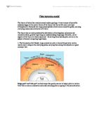
Divergent (constructive) boundaries
Divergent boundaries occur along spreading centers where plates are moving apart and new crust is created by magma pushing up from the mantle. Like two giant conveyor belts, facing each other but slowly moving in opposite directions as they transport newly formed oceanic crust away from the ridge crest.
Perhaps the best known of the divergent boundaries is the Mid-Atlantic Ridge. This submerged mountain range, which extends from the Arctic Ocean to beyond the southern tip of Africa, is but one segment of the global mid-ocean ridge system that encircles the Earth.
The rate of spreading along the Mid-Atlantic Ridge averages about 2.5 centimeters per year (cm/yr), or 25 km in a million years. This rate may seem slow by human standards, but because this process has been going on for millions of years, it has resulted in plate movement of thousands of kilometers. Seafloor spreading over the past 100 to 200 million years has caused the Atlantic Ocean to grow from a tiny inlet of water between the continents of Europe, Africa, and the Americas into the vast ocean that exists today.
The Mid-Atlantic Ridge, which splits nearly the entire Atlantic Ocean north to south, is probably the best-known and most-studied example of a divergent-plate boundary.
Convergent boundaries
The size of the Earth has not changed significantly during the past 600 million years, and very likely not since shortly after its formation 4.6 billion years ago.
The Earth's unchanging size implies that the crust must be destroyed at about the same rate as it is being created, as Harry Hess surmised. Such destruction (recycling) of crust takes place along convergent boundaries where plates are moving toward each other, and sometimes one plate sinks (is subducted) under another. The location where sinking of a plate occurs is called a subduction zone.
The type of convergence, called by some a very slow "collision", that takes place between plates depends on the kind of lithosphere involved. Convergence can occur between an oceanic and a largely continental plate, or between two largely oceanic plates, or between two largely continental plates.
Oceanic-continental convergence
If by magic we could pull a plug and drain the Pacific Ocean, we would see a most amazing sight -- a number of long narrow, curving trenches thousands of kilometers long and 8 to 10 km deep cutting into the ocean floor. Trenches are the deepest parts of the ocean floor and are created by subduction.
Off the coast of South America along the Peru-Chile trench, the oceanic Nazca Plate is pushing into and being subducted under the continental part of the South American Plate.
In turn, the overriding South American Plate is being lifted up, creating the towering Andes mountains, the backbone of the continent. Strong, destructive earthquakes and the rapid uplift of mountain ranges are common in this region. Even though the Nazca Plate as a whole is sinking smoothly and continuously into the trench, the deepest part of the subducting plate breaks into smaller pieces that become locked in place for long periods of time before suddenly moving to generate large earthquakes. Such earthquakes are often accompanied by uplift of the land by as much as a few meters
The convergence of the Nazca and South American Plates has deformed and pushed up limestone strata to form towering peaks of the Andes, as seen here in the Pachapaqui mining area in Peru.
Continental-continental convergence
The Himalayan mountain range dramatically demonstrates one of the most visible and spectacular consequences of plate tectonics. When two continents meet head-on, neither is subducted because the continental rocks are relatively light and, like two colliding icebergs, resist downward motion. Instead, the crust tends to buckle and be pushed upward or sideways. The collision of India into Asia 50 million years ago caused the Eurasian Plate to crumple up and override the Indian Plate. After the collision, the slow continuous convergence of the two plates over millions of years pushed up the Himalayas and the Tibetan Plateau to their present heights. Most of this growth occurred during the past 10 million years. The Himalayas, towering as high as 8,854 m above sea level, form the highest continental mountains in the world. Moreover, the neighboring Tibetan Plateau, at an average elevation of about 4,600 m, is higher than all the peaks in the Alps except for Mont Blanc and Monte Rosa, and is well above the summits of most mountains in the United States.
Transform boundaries
The zone between two plates sliding horizontally past one another is called a transform-fault boundary, or simply a transform boundary. The concept of transform faults originated with Canadian geophysicist J. Tuzo Wilson, who proposed that these large faults or fracture zones connect two spreading centers (divergent plate boundaries) or, less commonly, trenches (convergent plate boundaries). Most transform faults are found on the ocean floor. They commonly offset the active spreading ridges, producing zig-zag plate margins, and are generally defined by shallow earthquakes. However, a few occur on land, for example the San Andreas fault zone in California. This transform fault connects the East Pacific Rise, a divergent boundary to the south, with the South Gorda -- Juan de Fuca -- Explorer Ridge, another divergent boundary to the north.
The Blanco, Mendocino, Murray, and Molokai fracture zones are some of the many fracture zones (transform faults) that scar the ocean floor and offset ridges (see text). The San Andreas is one of the few transform faults exposed on land.
The San Andreas fault zone, which is about 1,300 km long and in places tens of kilometers wide, slices through two thirds of the length of California. Along it, the Pacific Plate has been grinding horizontally past the North American Plate for 10 million years, at an average rate of about 5 cm/yr. Land on the west side of the fault zone (on the Pacific Plate) is moving in a northwesterly direction relative to the land on the east side of the fault zone (on the North American Plate).
Aerial view of the San Andreas fault slicing through the Carrizo Plain in the Temblor Range east of the city of San Luis Obispo.