
"Geological activity is responsible for hazards which produce some extreme impacts in terms of loss of life and damage to property. If the consequences of such hazards are to be reduced, then appropriate management is necessary".
"Geological activity is responsible for hazards which produce some extreme impacts in terms of loss of life and damage to property. If the consequences of such hazards are to be reduced, then appropriate management is necessary". With reference to either volcanoes or earthquakes discuss the above statement. In your answer you should refer to examples and * briefly describe how geological activity produces such extreme impacts * show how the impacts of earthquakes and volcanic activity vary with the scale of the hazard and other factors * discuss the management strategies used to reduce the impact of volcanic eruptions or earthquakes * assess the success of such management strategies. The vast majority of earthquakes occur at plate boundaries because that is where sufficient stresses build up. The most powerful are at destructive plate boundaries where continental and oceanic plates converge e.g. the pacific and Philippine plates are being sub ducted under the Eurasian plate. They can also occur at mid plate too and are often triggered by human activity such as subsidence associated with deep underground mining or abstraction of underground water leading to sudden pressure changes. The impact depends on many factors strength of the earthquake, wealth of country ect. If the earthquake is high on the Richter scale then it has more of an impact. A shallow focus will cause

"How has the Development of the Theory of Plate Tectonics Changed Our Understanding of the Earth
"How has the Development of the Theory of Plate Tectonics Changed Our Understanding of the Earth?" The emergence of the theory of plate tectonics could be argued as being one of the most significant developments in terms of improving our understanding of the Earth. Not only does it explain the position, shape and composition of the continents it also provides an insight into how different species flora and fauna have evolved on them. The theory of plate tectonics is able to account for and explain many of the major features and landforms found on the earth's surface. Monroe and Wicndner (1992, p361) Because new lithosphere is formed at divergent plate boundaries, older lithosphere must be destroyed and recycled in order for the entire surface of the Earth to remain constant. Subduction zones do not generally occur at converging margins between two continental plates, at least not to the extent of the two other types of margin. This is because as Lutgens and Tarbuck (2002, p135) explain "neither plate will subduct beneath the other because of the low density and thus the buoyant nature of continental rocks." There is however massive mountain building, the best example of this probably being the Himalayas which resulted from the collision between the subcontinent of India and Asia. (Lutgens and Tarbuck 2002, p135) A convergent plate margin is where "plates

kobe earthquake
Question Two: Why did the Kobe Earthquake in 1995, do so much damage and kill so may people? The earth's surface is not all one big piece. It is broke down into several different pieces called plates. Each plate moves a few centimetres a year. The place were two plates join up we call a plate boundary. Major earthquakes and volcanoes eruptions take place at these plate boundaries. Japan is at the boundary of three plates. It is located were the pacific and the Philippians plates move towards the Eurasian plate. As the two plates meet the Eurasian plate they are forced downwards and under the Eurasian plate. The movement has resulted in lots of earthquakes and volcanoes all over the country killing many people and destroying much land and crops. The effects of the Kobe earthquake were of awful devastation. 5,000 people died in the earthquake and 350,000 were made homeless. This was an effect of the earthquake. But also gas pipes exploded and fires burnt all over the city, this was a secondary cause of death caused by the earthquake. Other secondary causes of death were underground water pipes burst all over the city. Large areas of Kobe were blacked because electricity lines were cut. With the smoke from the fires the search for survivors was difficult. Several hospitals in the old part of Kobe were destroyed in the earthquake. When the ground moved some of the buildings did
Why is New Zealand a dangerous place to live?
Why is New Zealand a dangerous place to live? New Zealand is located in the southwest of the Pacific Ocean, southeast of Australia. This beautiful country has many high lands, huge rivers and mountains, which are steep, very jagged and glaciated. There is plenty of ash over the North Island resulting from volcanic eruptions. What makes this amazing country so dangerous is that so many natural hazards exist here. New Zealand situated right through the ring of fire. This is a zone where frequent earthquakes and volcanic eruptions happen. New Zealand's volcanoes occur by the Indo-Australian plate going underneath the Pacific plate which melts causing the burst of lava, and the treacherous volcano. There is a long string of volcanoes here, some are extinct and some are active. This area is called the subduction zone. One big volcano, called White Island erupts every year. In Wellington there is a volcano that is next to an enormous fault. This could erupt at any time and if it does there will be disastrous results. 50 volcanoes surround the popular city of Auckland. In some places there is so much molten rock that the volcano could go underwater. If the water gets in, the whole city could be destroyed. Lake Taupo was formed 3000 years ago by a mammoth volcanic eruption. Another major natural hazard in New Zealand is the earthquakes. In 1931 Napia - South Island a massive

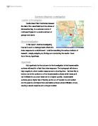
Kobe, Japan (Case Study)
Kobe, Japan (Case Study) Japan is positioned on the margin of the Eurasian Plate. The Philippine Sea Plate is subducted below the Eurasian plate, resulting in Japan having greater than average seismic and volcanic activity. Immediately south of Osaka Bay is a fault called the Median Tectonic Line, and it was sudden movement along this fault that triggered the earthquake that hit Kobe. Kobe is located farther than many other cities in Japan from the dangerous intersection of three tectonic plates: the Pacific, Eurasian, and Philippine. This triple junction is a junction of three compressive subduction zones. There had been a subduction fault that had already been broken in great earthquakes in 1944 and 1946. Kobe is also somewhat off the Median Tectonic Line, a zone of strike-slip faults. At 5.46am on January 17th 1995, whilst many of its people of Kobe were still asleep, the Japanese city of was hit by the largest earthquake in Japan since 1923. The earthquake was not only powerful (Richter scale 6.9 ), but with the epicenter only 20km southwest of the city, it resulted in massive damage to property and loss of life. The worst effected area was in the central part of Kobe, a region about 5km by 20km alongside the main docks and port area. This area is built on soft and easily moved rocks, especially the port itself which is built on reclaimed ground. Here the ground

Investigate the rate of which lava flows down the side of a volcano and what affects the rate of which it flows.
Lava Flow Aim My aim is to investigate the rate of which lava flows down the side of a volcano and what affects the rate of which it flows. Planning In this investigation there are many different variables these are; * Angle of slope * Surface of volcano * The amount of lava * The temperature of the lava * The environmental conditions * The viscosity of the lava * How far it has to flow * The force of the eruption I have decided to investigate the angle of the slope because I will be doing the investigation in a school lab. So I will not be able to use real lava or a real volcano so I will use golden syrup instead of lava and a tile instead of a volcano slope. I also think that it will be easiest to set up and get accurate results. I predict that the higher the angle of the slope the faster the lava will flow down the slope. I have made this prediction from my scientific knowledge. I think this because the higher the angle gets the more gravitational potential energy (GPE) will be acting on the lava. So what is GPE well it is a type of energy that is stored in an object because of its height through which it has been lifted against the force of gravity. If it falls down we know that it has got gravitational potential energy. So it will be forced down the slope at a higher force. GPE is linked to kinetic energy. GPE that is acting on the lava can make it move
Extreme Weather Investigation
Extreme Weather Investigation Location of Investigation Castle Head Field Centre lies between the fells of the Lake District and the shores of Morecambe Bay, in a secluded corner of northwest England in a small rural town of grange over sands. Aim of Investigation In this report I shall be investigating how land-use in a drainage basin affects the rivers response to a rainfall event. I shall be describing the various methods of research, deeply analysing my findings and concluding the results I have found the my hypothesis. Hypothesis My hypothesis for the outcome for the investigation is that impermeable surfaces will result in a flash flood river response. The hydrograph will show a high magnitude, short duration response and a short lag time. I believe this to be true due to the surface run off on impermeable surfaces which because it can't infiltrate it runs down faster and in a higher quantity. Impermeable surfaces give a higher risk of flooding as the run off duration is a lot quicker and the peak is a lot higher than permeable surfaces where infiltration occurs causing a slower response and a longer duration. Method Part 1: Simulating Drainage Basins The investigation was based around four different surface types representing drainage basins, to test the response of each surface. The first surface was bare earth witch consisted of various materials including

"What are the physical processes that cause geomorphic hazards? What problems do they cause for people?"
"What are the physical processes that cause geomorphic hazards? What problems do they cause for people?" The relationship between people and the terrain in which the live on, off and around has been closely co-dependent for thousands of years. In this essay I am aiming to discuss how and the reason how physical processes cause geomorphic hazards, including case studies around the world, where relevant, to show the causes and effects of such hazards. I also want to explain and describe how they have affected the everyday lives of millions of people in every corner of the World. Mass movement processes are the result of physical processes exerted by man (i.e. Farming methods) to natural processes (i.e. Earthquakes). When I talk about mass movement processes, this involves large masses or quantities of land material caused by a number of factors. The factors include: * Erosion by rivers, glaciers, or ocean waves create too steep slopes * Rock and soil slopes are weakened through saturation by snowmelt or heavy rains * Earthquakes create stresses that make weak slopes fail * Earthquakes of magnitude 4.0 and greater have been known to trigger landslides * Volcanic eruptions produce loose ash deposits, heavy rain, and debris flows. * Excess weight from accumulation of rain or snow, piling of rock or ore, from waste piles, or from man-made structures may stress weak
Measuring the Intensity of Earthquakes.
Earthquakes General An earthquake is a shaking or trembling of the crust of the earth caused by underground volcanic action or by the breaking and shifting of rock beneath the surface. The volcanic action and shifting rocks create strain which continues to build to a sudden release of pressure resulting in a shock wave. The vibrations produced in the crust can vary from barely noticeable to enormously destructive. Shock waves can be classified into two broad categories. Waves that send particles oscillating back and forth in the same direction as the waves are traveling are called primary. Primary waves, sometimes called compressional waves, travel through the earth beneath the crust. Secondary waves cause vibrations which move perpendicular to the wave. These waves travel on the surface of the earth and move much slower than primary waves. Thus, when an earthquake occurs, seismic centers throughout the world record primary waves before the secondary waves arrive. Historical Overview Earthquakes have captured the imagination of people living in earthquake prone regions since ancient times. Ancient Greek philosophers thought quakes were caused by subterranean winds, while others blamed them on fires in the bowels of the earth. About AD 130, a Chinese scholar named Chang Heng reasoned that waves must ripple through the earth from the source of an earthquake. By 1859, an
At what points in this novel do you feel its author is breaking out of realist modes of story telling into the realms of fantasy?
At what points in this novel do you feel its author is breaking out of realist modes of story telling into the realms of fantasy? It is these bursts of fantasy, mentioned in the title, which Carter injects into her work of fiction 'Wise Children' that makes this novel the perfect example of the carnivalesque. This term accounts for the surrealism of the novel which moves away from the tragedies of Dora's tale, celebrating the lighter side of life. According to Daphne Moor, the main features of the carnivalesque include intertextuality, 'the levelling or inversions of hierarchies,' 'revelry and celebration', 'the chaos of change and of fluctuation', 'laughter that regenerates even as it reduces', and finally the 'acknowledgement of the body and its cycles of birth, aging and death as well as the organic functions of eating'. All of these factors are applicable to 'Wise Children'. Although there are elements throughout the first chapter, one of the best examples of the carnivalesque here is when Carter first introduces us to Perry. He is in fact portrayed by Carter in this way as she does not trap him in Dora's dialogic, polyphonic narration, but also allows him to have a magical, spontaneous quality about him so that pandemonium seems to follow him through each page. He himself is portrayed as a travelling carnival. These qualities are evident throughout his life as he


