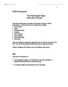
Mouth of the River Bride 1937 - the river finds its way through the shingle on the beach
River Survey of the River Bride
Introduction
On Friday 9th of May we ventured to Osmington Bay in Dorset. We went to
Dorset in order to conduct a river study of the River Bride. The undertaking of a river
study was for Geography Coursework that would contribute to our final GCSE
mark. We spent the first day studying the River Bride, specifically 10 sites from the source to the mouth representing changes in the river.
The River Bride was chosen because of its array of river features.
These include:
River cliffs
Meanders
Slip Off Slopes
Vegetation
Springs
Tributary
Old River Channel
It was easy to see why the River Bride was chosen as it embraced all those
features listed above situated in the same place. It gave us a chance to
test a vast array of hypothesis in the same day.
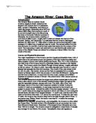
SOUTH-WEST ENGLAND
DORSET COASTLINE
COASTLINE
RIVER BRIDE AREA
Background Information
The majority of the catchment area for the River Bride is the Bride Valley. The valley runs east-west and as a result the river runs parallel to the coast, generally an unexpected phenomenon. The hills creating the valley reach over 180m in height. They are made of Bridport sandstones and limestones lying over Gault and Wealden Clay, creating a set of springs. The river itself falls 100m over the 12.75km course giving it a gradient of almost 1 in 130 making it one of the steepest rivers in the country.
At Little Bredy a lake forms from the pooling on clay of many small springs in an area known as Brideshead.
The Bride passes south of Litton Cheney a 17th and 18th century village built along winding roads and tributary streams to the Bride.
At Modbury, the steam passes through an organic farm. The Bride then undergoes its most diversion due to human influence. Large amounts of water are diverted into flood plains as part of a fish farm. The used water is returned to the course after use.
Entering Burton Bradstock the river winds its way through housing estates and past a school until it enters the Freshwater Bay caravan park. The most exciting and unusual part of the course is here where the river would normally flow undisturbed into the sea. Here the river meets the back of Chesil Beach at the sea. Chesil beach is on the longest Tombolos in the world. It runs from the Isle of Portland in the east, 29 km to West Bay in the west where when it meets the harbour it officially ends.
At Burton Bradstock the beach is attached to the land. The beach is made of shingle, large pebbles sorted with the smallest at West Bay, and it is material the water percolates through. The water flows easily through the shingle where large pore spaces allow free flow. Smaller sediment fills these pore spaces nearer the bottom of the beach and the water is forced down the gradient of the beach where it reappears flowing towards the sea. This process is affected by the tides. A high tide or storm will create back flow in the Bride at the mouth and huge flooding can result. There are large flood schemes at the caravan park to prevent what would be large-scale damage on the narrow flood plain.
River Survey of the River Bride
Introduction
On Friday 9th of May we ventured to Osmington Bay in Dorset. We went to
Dorset in order to conduct a river study of the River Bride. The undertaking of a river
study was for Geography Coursework that would contribute to our final GCSE
mark. We spent the first day studying the River Bride, specifically 10 sites from the source to the mouth representing changes in the river.
The River Bride was chosen because of its array of river features.
These include:
River cliffs
Meanders
Slip Off Slopes
Vegetation
Springs
Tributary
Old River Channel
It was easy to see why the River Bride was chosen as it embraced all those
features listed above situated in the same place. It gave us a chance to
test a vast array of hypothesis in the same day.
SOUTH-WEST ENGLAND
DORSET COASTLINE
COASTLINE
RIVER BRIDE AREA
Background Information
The majority of the catchment area for the River Bride is the Bride Valley. The valley runs east-west and as a result the river runs parallel to the coast, generally an unexpected phenomenon. The hills creating the valley reach over 180m in height. They are made of Bridport sandstones and limestones lying over Gault and Wealden Clay, creating a set of springs. The river itself falls 100m over the 12.75km course giving it a gradient of almost 1 in 130 making it one of the steepest rivers in the country.
At Little Bredy a lake forms from the pooling on clay of many small springs in an area known as Brideshead.
The Bride passes south of Litton Cheney a 17th and 18th century village built along winding roads and tributary streams to the Bride.
At Modbury, the steam passes through an organic farm. The Bride then undergoes its most diversion due to human influence. Large amounts of water are diverted into flood plains as part of a fish farm. The used water is returned to the course after use.
Entering Burton Bradstock the river winds its way through housing estates and past a school until it enters the Freshwater Bay caravan park. The most exciting and unusual part of the course is here where the river would normally flow undisturbed into the sea. Here the river meets the back of Chesil Beach at the sea. Chesil beach is on the longest Tombolos in the world. It runs from the Isle of Portland in the east, 29 km to West Bay in the west where when it meets the harbour it officially ends.
At Burton Bradstock the beach is attached to the land. The beach is made of shingle, large pebbles sorted with the smallest at West Bay, and it is material the water percolates through. The water flows easily through the shingle where large pore spaces allow free flow. Smaller sediment fills these pore spaces nearer the bottom of the beach and the water is forced down the gradient of the beach where it reappears flowing towards the sea. This process is affected by the tides. A high tide or storm will create back flow in the Bride at the mouth and huge flooding can result. There are large flood schemes at the caravan park to prevent what would be large-scale damage on the narrow flood plain.