How do river characteristics vary downstream?
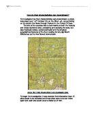
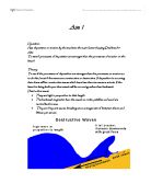
How do river characteristics vary downstream? To investigate how river characteristics vary downstream, a study took place over 1-3rd October '03, on the River Lyd, concentrating on the stretch that flows through Parkend in the Forest Of Dean. The aim of the exercise was to look mainly at both the Velocity and Cross Sectional Area, comparing and studying the data, but also Hydraulic radius, wetted perimeter and the physical geographical features of the river, looking for any significant differences as the river flowed downstream. Above: [fig.1] Map showing River Lyd & investigation sites To begin the investigation, it was decided that information from 12 sites would to be recorded and these sites were to be set 100m apart and each site would cover a distance of 10m. Equipment used included: * 3 range poles - steepness of riverbed and depth * Stop watch - timing pooh stick * Clinometer - Angle of slope of the riverbed * Pooh stick / Orange - calculating velocity * Tape measure - cross sectional area Method . Insert the range poles across the riverbed at equal distances (left, centre and right), measure the depth at each and calculate an average. Taking these measurements at each site gives data on the average depth of the river along its course, and will show whether the distance from the source affects the rivers depth. 2. Take the tape measure across the width
Wind is an important agent of Deposition and transportation. It's role as an Eroder remains questionable.
Wind is an important agent of Deposition and transportation. It's role as an Eroder remains questionable. No deserts are completely rainless although parts of the Libyan and Chilean deserts approach complete aridity. In such places erosion is extremely slow, although occasional showers can have sudden catastrophic effects. Trujillo in Peru received only 1.4 inches of rain between 1918 and 1925, but during March 1925 it received 15.5 inches, of which 8.9 inches fell in the three days 7-9 March. Such events apart, the present work of landscape development are controlled by the wind. (Outside the true deserts, vegetation prevents wind from being a significant agent or erosion), although it can carry enormous quantities of dust far beyond the deserts and can move sand and dust into characteristic depositional forms. It is certain that wind cannot be responsible for most of the eroded landforms of present day deserts, and it is also certain that many of the landscape features of the African and Asian deserts were produced in times of wetter climate. In the Sahara, for instance, there are numerous old lakebeds, which have been dry for a great length of time. From mountains like the Ahaggar radiate systems of valleys which could have been cut only by running water, but which are now completely dry and choked by invading sand-dunes. There is considerable biological evidence of
Change in land use along the River Tees.
Change in land use along the River Tees The River Tees begins high up in the Pennines and follows an easterly course towards the North Sea. The land in the River Tees upper course is high (893m above sea level at the source) and rainfall is over 2000mm a year. The valley is steep sided and V shaped, as the river has not yet flattened the land (though the river has began to erode laterally). The river is turbulent and the riverbed is rocky, this has caused rapids and High Force, which is the highest waterfall in England. Due to the steep slopes and harsh climate the building of communications links was very challenging and therefore settlements are extremely rare, limited to isolated farmhouses. Employment opportunities are also restricted to mainly agriculture and forestry related jobs; as a result the population density in this part of the river valley is extremely low. On the bleaker moorlands there is practically no settlement at all, however there are a few more farms and small villages situated along the B6277 road which leads into more sheltered land in the Tees valley. High rainfall in this part of the river's course provides a reliable water supply. There are several manmade reservoirs found in this part of the course, the highest being Cow Green reservoir. These reservoirs help control flooding as well as providing high quality water for homes and industries

Spectrophotometric determinetion of phosphate in river water
SPECTROPHOTOMETRIC DETERMINETION OF PHOSPHATE IN RIVER WATER (GROUP 3) NAME: Leo Chiedu Aim Phosphorus is one of the most abundant elements on earth, though not found alone but in a combined form as phosphate. Phosphate is found in earth's crust, rivers and lakes. In these experiment known concentrations of phosphates in solutions was used to determine the concentration of water samples from a river, lake and an unknown water sample. This was determined assuming the colour intensity and absorbance of each solution using a spectrophotometer, the experiment aims at familiarising each group with a typical spectrophotometer analysis. The experiment also aims at comparing the river water value and set guidelines by the European Union. The error associated with the class values and spectrophotometer determination of values, was achieved using, rank correlation, regression and ANOVA one - way to the check the mean values, standard deviation and 95%confidence intervals. INTRODUCTION Nature has provided human being a source of natural occurring elements and compounds. Phosphorus is the eleventh most abundant element on earth and exists in four allotropic forms; red, white (or yellow), black (or violet). When pure phosphorus is colourless and transparent. Phosphorus is insoluble in water, although, elemental phosphorus is extremely reactive and will combine with oxygen (O2)
How A River Changes As It goes Downstream.
How A River Changes As It goes Downstream A rivers course starts in the mountains or relatively highland area and ends up meeting the sea. As a river travels downstream it changes in many ways. Different features are made and different processes take place. These things take place in different stages of the river. There are 3 stages in total. The upper course, the middle course and the lower course. In the upper course, the start of the river is called the source. It is usually a small lake or spring. In the mountains there are also small tributaries that feed into the main river at the confluence. In this particular part of the course the width is small and the depth is very shallow. The channel gradient is very steep allowing the water to just trickle down the hill because it hasn't got enough water to flow. The velocity is also very minor. In this part of the course, erosion is the dominant process. The river may erode creating different features by any of the four erosion processes. They are hydraulic power, which is the force of the water against the riverbed and bank removing material. This is particularly important when the river is in flood. Corrasion is when the particles of sand, silt, pebbles or boulders carried by the river rub against the bed and banks, wearing them away. The third is corrosion, which is when rocks dissolve in the slightly acidic water. The

To see how a river and its characteristics change with increasing distance downstream.
AIM To see how a river and its characteristics change with increasing distance downstream. OBJECTIVES . To see how mans influence effects the river. 2. To see if width, depth, velocity, bedload size, biological content and chemical content change downstream. HYPOTHESIS . Width should increase with increasing distance downstream. 2. Velocity should increase with increasing distance downstream. 3. Depth should increase with increasing distance downstream. THEORY An ideal river THE UPPER COURSE- In the upper course, the river is above its base level. This gives the river a lot of potential energy. The river is trying to cut down to its base level so mainly erodes in a downward direction. This helps to create the v-shaped river valleys in upland areas. THE MIDDLE COURSE- As the river flows downstream the gradient becomes less steep. Lateral erosion becomes more important than vertical erosion and the river starts to meander. Some of the rivers energy is also used to transport eroded material downstream. THE LOWER COURSE- The river is now nearing its mouth and deposition becomes the most mportant process encouraged by the large load carried by the river, any obstruction, any fall in the volume or any loss of velocity. The table below shows different features at the upper middle and lower courses of a river Upper course Middle course Lower course River
Has deposition or erosion by the sea been the main factor shaping Deal beach?
Aim 1 Question: Has deposition or erosion by the sea been the main factor shaping Deal beach? Aim: To test if processes of deposition are stronger than the processes of erosion on the beach Theory: To see if the processes of deposition are stronger than the processes or erosion so to do this I must if the waves are constructive or destructive. If deposition is occurring then there will be constructive waves which have less than ten waves a minute. If the beach is being built upon then swash will be occurring rather than backwash. Destructive waves * They are high in proportion to their length * The backwash is greater than the swash so rocks, pebbles and sand are carried back to sea. * They are frequent waves, breaking at an average rate of between eleven and fifteen per minute. Constructive waves: * They are long in relation to their height * They break gently on the beach so that the swash carrying materials up the beach is stronger than the backwash carrying them away. * They break gently with between only six to nine waves per minute Method: First of all we chose a time at which we would start recording the results for the wave count; this was nearer to the end of the data collection trip. Two members of our group then counted the waves every minute for ten minutes so we could see if there was constructive wave or destructive wave. If the beach was being

There are three sections in a river they are called: The upper Course, The Middle Course and The Lower Course.
A river transports material through: Deposition occurs when the river starts losing energy. Heavy particles are deposited first. The light material is transported. Eventually most of the lighter material is then deposited, although sometimes not until the river reaches the mouth. The three sections of a river There are three sections in a river they are called: The upper Course, The Middle Course and The Lower Course. The upper Course, is the steepest part of land in the river. It is usually small, but flows very fast. The energy levels are high and the river cuts away at its bed. As it does it quickly deepens its valley through down cutting. This creates a steep sided V- shaped valley. Downward erosion is the dominant process. In The Middle Course, the river starts to flow slowly because it starts to transport lots of sediment, as rivers look muddy. As a river moves down its valley, a number of changes occur. The river gets wider, as more tributaries join together. * The valley sides become less steep, giving the shape of a open V. * The river begins to erode sideways, into its banks. This opens out the valley floor and a flood plain that starts to develop. * Erosion and deposition occur. * The edges of the floodplain are marked by bluffs. The lower Course, is when the valleys V shape is so wide that he valley sides have been
Wind is an important agent of transport and deposition. It's effectiveness as an eroder remains questionable. Discuss.
Wind is an important agent of transport and deposition. It's effectiveness as an eroder remains questionable. Discuss. A desert can be defined as any region that receives less than 25cm of rain per year where evapo-transpiration equals or exceeds precipitation or in other terms where there is a permanent moisture deficit. Arid areas cover one third of the earth's land surface and there is an enormous amount of variety within in them. Most of these deserts lie in the tropical and subtropical belts between 20o and 30o north and south of the Equator. Wind, as in other physical systems, can erode, transport and deposit but as stated its role as an eroder remains open to discussion. Transport in deserts is carried out in three processes, being suspension, through the air less than 25 metres above ground level; saltation, where grains bounce a few cm above the ground; and surface creep. In suspension very fine material is picked up by the wind, raised to considerable heights and carried great distances. The finer materials are taken away leaving behind a lag deposit. Transport is effective and important here in that in 1km of air, 900 tonnes of sand can be entrained. In some case red dust from the Sahara has been carried northwards and deposited as 'red rain' over parts of Britain and has been found in places as far away as Hawaii. Dust Storms such as the above have increased
The characteristics affecting the flow of a river.
The characteristics affecting the flow of a river Introduction This investigation will be based upon what characteristics affect a river. In this piece I will investigate how the stream characteristics change as you go downstream. A specific area has been chosen to study, which is Aberarth. In this chosen site is a river, which is called the river Arth. Aberarth is situated about 2 miles from Aberaeron on the way to Aberystwydd. Its beach is a pebble beach and id surrounded by cliff. It is a small sea side village and may have been a site for fishermen. Now Aberarth is well known for its surf and beach. Hypothesis My hypothesis is that as you go downstream the pebble size tend to be smaller and also more rounder in shape. Furthermore the river channel widens and also deepens; hence an increase in the cross sectional area. The further downstream you go, the less the gradient, i.e. the flatter the land. Also the further downstream you go, the more the number of meanders will be found, as the land is flatter. A further hypothesis would be to say that the more downstream you move the more discharge (amount of water in river). Therefore increases as you go downstream. Ideal Stream Model Information on rivers All rivers start at the source and end at the mouth which leads into the sea or another river. The source is usually on high land such as mountains and therefore the


