
The Power of the River in A River Runs Through it.
The Power of the River in A River Runs Through it Water has always played significant roles in stories as well as in our lives. Throughout time, it has always been considered powerful, majestic, and respected. In Norman Maclean's A River Runs Through it. This image of water is clearly seen. The entire timeline of the story begins at the river and ends at the river. The author's love and respect of the river indicted him to refer to it many times, and in many different ways. Sometimes just as a river, but mostly he referred to it metaphorically and symbolically as not just a river that flows with no meaning, but of something wonderful and important that beautifully travels with no end. The river itself had been the center of Paul and Norman's life. It was said that, "In our family, there was no clear line between religion and fly-fishing"(1). Being Presbyterians, and sons of a Reverend, but also being sons of a fly-fisherman on the Big Black foot. Norman and Paul learned from their father that "man by nature was a mess and had fallen from an original state of grace"(2). But they also learned that "all good things-trout as well as eternal salvation-come by grace and grace comes by art and art does not come easy"(3). Theodore Weinberger said in "Religion and Fly fishing: Taking Norman Maclean Seriously" that "To practice an art is to glorify God. Art allows the
River Valley Project
Major River Valley Project * Muti-purpose River Valley Project o A huge dam or a series of dams built on a river and it's tributaries to satisfy many purposes, other than just generating hydel-power, and that too simultaneously. India has come a long way in this field as it has numerous numbers of these projects. * Aims o As the name suggests, there are many purposes of a Muti-purpose River Valley Project. The following are some of them: - * Hydro-electricity production * Avoiding floods and famines * Irrigating fields * Protecting the soil * Supporting afforestation and preserving the natural Ecosystem * Inland navigation ways * Providing fishing grounds * Increasing tourism o Some River Valley Projects of India are as follows * Bhakra Nangal Dam- * River -Satluj * Storage - 7,80,000 hectare-metres * Lakes - guru Gobind Sagar. * Irrigation - 1.4 million hectares * Power -The Nangal Power Plant - 1204 mw annually * Areas -Himachal Pradesh, Punjab, Haryana, Rajasthan and Delhi. * Specialty -highest gravity dam in the world at a height of 226 metres. * Damodar Valley- * River -Damodar * Irrigation -.5 million hectares. * Areas - Bihar and west Bengal * Speciality - First in India. coal and iron-ore deposits. * Indira Gandhi Canal Project- * River - Ravi and Beas * Canal length - 468 Km(main canal) * Storage -690000 hectare metres *

River Steyr, Hinterstoder
Geography: River Course Work River Steyr, Hinterstoder October 2002 Vanja Ivancevic 11F Contents Page 1 - Title page Page 2 - Contents Page 3 - Introduction Page 4 - Introduction Page 5 - Base Map Page 6 - Strahlers Stream Ordering of the Steyr Page 7 - Relief Map of the Steyr Page 8 - Aims Page 9 - Hypothesis Page 10 - Theoretical Background Page 11 - Theoretical Background Page 12 - Data Collection Page 13 - Data Collection Page 14 - Data Presentation, Location 1, Description Page 15 - Data Presentation, Location 1-4, Bedload Sampling Page 16 - Data Presentation, Location 2, Description Page 17 - Data Presentation, Location 2, Tabular Data Page 18 - Data Presentation, Location 2, Graphical Data Page 19 - Data Presentation, Location 3, Description Page 20 - Data Presentation, Location 3, Tabular Data Page 21 - Data Presentation, Location 3, Graphical Data Page 22 - Data Presentation, Location 4, Description Page 23 - Data Presentation, Location 4, Tabular Data Page 24 - Data Presentation, Location 4, Graphical Data Page 25 - Data Analysis and Discussion, Location 1 Page 26 - Data Analysis and Discussion, Location 2, Hydraulic Radius and Discharge calculations Page 27 - Data Analysis and Discussion, Location 2, Spearman's Bedload/Velocity Rank Correlation Tabular data & Graph Page 28 - Data Analysis and Discussion,
Change in land use along the River Tees.
Change in land use along the River Tees The River Tees begins high up in the Pennines and follows an easterly course towards the North Sea. The land in the River Tees upper course is high (893m above sea level at the source) and rainfall is over 2000mm a year. The valley is steep sided and V shaped, as the river has not yet flattened the land (though the river has began to erode laterally). The river is turbulent and the riverbed is rocky, this has caused rapids and High Force, which is the highest waterfall in England. Due to the steep slopes and harsh climate the building of communications links was very challenging and therefore settlements are extremely rare, limited to isolated farmhouses. Employment opportunities are also restricted to mainly agriculture and forestry related jobs; as a result the population density in this part of the river valley is extremely low. On the bleaker moorlands there is practically no settlement at all, however there are a few more farms and small villages situated along the B6277 road which leads into more sheltered land in the Tees valley. High rainfall in this part of the river's course provides a reliable water supply. There are several manmade reservoirs found in this part of the course, the highest being Cow Green reservoir. These reservoirs help control flooding as well as providing high quality water for homes and industries
"The Hydrological Study Of the River Conwy"
GCSE Coursework "The Hydrological Study Of the River Conwy" This project will study the transition of the River Conwy as it flows downstream. It will concentrate on the following variables: * Water Width * Depth * Wetted Perimeter * Gradient * Flow Velocity * Float Velocity * Stone Roundness * Stone Size Another variable we could have measured is the pH value of the water in the river. This would have detected pollution levels as it goes downstream. These 8 variables will provide us with the sufficient information. Aims The aims of the project are: . To investigate changes in the channel form and river processes at different sites downstream on the River Conwy. 2. To identify landforms associated with river processes Hypothesis The following hypotheses were tested: . Downstream, the width will increase. 2. Downstream, the depth will increase 3. Downstream, the velocity will decrease 4. Downstream, the cross sectional area will increase 5. Downstream, the discharge will increase 6. Downstream, the gradient will decrease 7. Downstream, the wetted perimeter will increase 8. Downstream, the bed load size will decrease 9. Downstream, the bed load roundness will increase. Background Information Site 1- (Nant-y-Brwyn) Ref- 792 450 Nant-y-Brwyn was the site highest above sea level and therefore the nearest to the source, which we studied. This site
River Tees Drainage Baisin
River Tees Drainage Baisin The river Tees flows from the Pennines in Cumbria, northwest England, to the North Sea via Tees Bay. Its length is 130 km / 80 miles. Its port, Teesport, handles in excess of 42 million tonnes of water per year. Its main tributaries are the Lune, Balder, and Greta. There are many factors affecting the drainage baiins of the River Tees, many of these are human factors. Water Barrage and Watersports: Much of the water nearing the sea is polluted with industrial waste, sewage, and chemicals. The Tees Barrage, which opened in 1995, enables a 16 km / 10 mile stretch of the river to provide clean, non-tidal water. The barrage was built to improve the river's watersports facilities by stabilising a stretch of the river which was previously tidal. Four flood gates are operated by hydraulic pistons making sure the river upstream stays at a constant level. Forestry: Much of the Tees Forest has been felled to make room for the built up areas along the river. This decreases the amount of interseption taking place and unnatural concrete surface speed up the flow of runoff into the river. The areas of forest left at river side intersept rain and slow it down, with some also entering the biomass store when the okats absorb the water. Water Treatment: Northumbrian Water operates the Tees raw water system to supply major industrial users with large amounts of

Characteristics of a river
To what extent do the characteristics of the Moka River change downstream? Candidate name: Candidate number: This coursework is on the study of the Moka River (Mauritius), a tributary of Grand River North West. It is for the IGCSE exams of November 2009. The aim of the coursework is to find out whether or not the Characteristics of the Moka River change downstream. Mauritius is located in the Indian Ocean. It is a small volcanic island, consisting of young rivers, which is conical in shape. Due to this most rivers flow in a radial pattern and obtain their source from the central plateau, the Moka River is one of them. Since all rivers follow a certain pattern (refer to the Bradshaw model), part of the coursework will be dedicated to finding out how well the River Moka follows the pattern. In order to do this nine different sites were surveyed, measuring a total length of 13 kilometres (km) out of the river's total 18km. The Moka River was the main choice for the coursework as it was providentially located near to our school. Several hypotheses will be used in order to try and decipher whether or not the Moka River's characteristics change downstream, and how well it follows Bradshaw's model also they will be used to examine if the Moka River follows a concave or convex long profile. Hypothesis : Width and Depth increase Downstream 2: As velocity increases downstream
River Landscapes and Processes
River Landscapes and Processes Some important words and definitions: . Fluvial Landscape - a landscape created by rivers and their tributaries. 2. Tributary - a small river or stream which joins to a larger one. 3. River or drainage basin - an area drained by a single river together with all of its tributaries. 4. Confluence - where 2 or more streams, rivers or tributaries join together. 5. Watershed - The boundary line between different river/drainage basins. (Sometimes these are referred to as Catchment areas) 6. Source - The starting point of a river or stream. (watercourse) - This maybe a spring or just an area of boggy/marshy land. 7. Channel - the space between the banks of the watercourse in which the river flows, and may vary form a few meters to hundreds of kilometres. 8. Mouth - the point at which the river enters the sea or a lake. 9. Delta - the mouth of a river that splits into many channels (or distributaries) e.g. The River Mississippi or the River Nile. 0. Long Profile - the cross-section of a rivers course from its source to its mouth. 1. Cross Profile - a section across the valley of the river at any given point. How Do Rivers Shape The Land? There are 4 main processes by which a river can cause erosion (wearing away) and 4 processes by which a river can transport (move) material. * Processes of erosion . Attrition - breaking up of material
Evaluations of River Coursework
Evaluations My first hypothesis stated that velocity of the river increases downstream. This was measured by timing how long it took for an orange to travel 10 metres downstream. There were many problems with this method. Firstly, the orange used was quite heavy, and when in the water, most of it was submerged, therefore it moved more slowly. The orange did not travel at its true velocity. In many places there were twigs, leaves and weeds in the river, thus blocking the oranges path and slowing it down. I tried to make sure that the orange was put in the water ahead of the ten metre measuring distance so it had chance to reach its velocity before measuring began. However there were inconsistencies at each site, and sometimes access to the water was limited and this could not happen. Different people were used on the stop watch; everyone has different reactions and would have stopped the watch according to their judgement about when the orange had crossed the 10 metre line. The orange was difficult to keep in the middle of the river. Although I stated that we would do the measuring in a straight section of the river, this was not always possible, because some sites made access to the river difficult. My results were affected because the above factors denied the reading from being accurate and in some cases gave a false result for velocity. As my results were slightly faulty,
Measurments of a river
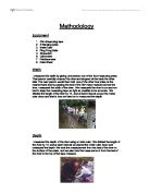
Methodology Equipment . 50m Measuring tape 2. 2 Ranging poles 3. Meter ruler 4. Ping Pong Balls 5. Stopwatch 6. Clinometer 7. Pebbleometer 8. Data Sheet Width I measured the width by giving one person one of the four measuring poles. That person carefully crossed the river and stopped at the bank the other side. The next person would then hold one of the other four poles at the nearest bank and by passing the end of the 50m tape measure across the river, measured the width of the river. We measured the river in cm and we had to keep the measuring tape as tight as possible to be accurate. We divided the length of the river by 10, and at each interval we put the meter ruler down and that is how we went on to measured the depth. Depth I measured the depth of the river using a metre ruler. We divided the length of the river by 10, and at each interval we placed the meter ruler down and measured the depth. We took the measurement from the bed of the river to the surface of the water, and we also took the measurement from the bed of the river to the top of the tape measure. Flow I measured the flow of the river by firstly getting one member of my team to carefully stand in the river at the left side near the bank. That person then dropped one of the plastic balls into the water. When the ball had travelled the 10meter length I had measured for it to travel, I


