
Evaluate the Role That the Tri-Cellular Model of Atmospheric Circulation has in Dictating Global Climate
Evaluate the Role That the Tri-Cellular Model of Atmospheric Circulation has in Dictating Global Climate The Tri-Cellular Model of Atmospheric Circulation shows how energy is redistributed across the globe and ensures there is not a surplus at the equator and deficit at the poles, which would be caused by the differential heating of the Earth’s surface by the Sun. The tri-cellular model is made up of three different air masses which control atmospheric movements and the redistribution of heat energy. The three air masses, starting from the equator, are called the Hadley cell, Ferrel cell and the polar cell. Between the two Hadley Cells is an area of low pressure in equatorial latitudes known as the inter-tropical convergence zone (ITCZ). Here, at the equator, the sun is always high in the sky so this area receives a large amount of solar insolation so the ground heats rapidly in the day and there is a lot of surface evaporation and the air becomes extremely humid. As the hot air rises in convection currents an area of low pressure develops. This rising air cools and water vapour eventually condenses into cumuliform clouds and heavy rainfall results. Weather stations in the equatorial region record precipitation up to 200 days each year, making the equatorial and ITC zones the wettest on the planet. The equatorial region lacks a dry season and is constantly hot and humid
Hurricance Katrina compared with Typhoon Tip
Tropical Storms Hurricane Katrina vs. Typhoon Tip Ben Mercer Introduction * Tropical storms are formed through a process called Tropical Storm Genesis * For TSG to occur certain factors need to be met * The ocean must be at the temperature of 26o or above for 50m depth from the surface this means areas within the trade wind belt, where warm winds heat up the surface, are more likely to experience the formation of tropical storms. Also the ocean temperatures are the highest at the start of autumn as they've been heated up for the duration of the summer meaning tropical storms are likely to occur around this time. * They usually start between 5-20o north or south of the equator and travel in a westerly direction. * After the pass onto land from the sea (landfall) they more towards the nearest poles, however away from the oceans they lose power due to the lack of a heat source and eventually become storms before being classified as depressions. * Atlantic Hurricanes are generally formed in the gulf of Mexico as the enclosed area means it can be heated up quicker and looses less heat * Tropical storms are first seen as Tropical Depression and then once they become stronger they become Tropical Storms they then go up the categories from 1 to 5. * The name differs depending on where the storm formed. If it is formed in the Atlantic then it is a hurricane, if it is formed

Differences In Weather Across The UK
Differences In Weather Across The UK There are six different ways that effect weather and vary it, they are: * Prevailing winds * Altitude * Latitude * Ocean currents * Distant from sea * Aspect Several of the above effect weather in the UK. But the regional climates in the UK are summarised as: * Northwest - cool summers, mild winters, heavy rain all year * Northeast - cool summers, cool winters, steady rain all year * Southeast - warm summers, mild winters, light rain all year, especially summer * Southwest - warm summers, mild winters, heavy rain all year, especially winter Latitude Latitude can affect climate as places closer to the Poles are cooler than places closer to the equator. This is because the sun is increasingly at an angle to the earth's surface as you travel closer to the Poles, meaning it has a larger area of land to heat. This means that the North of the UK is going to be colder than the South. Temperatures in the summer are lower in the northeast (place B) than in the southeast (place D) because of the latitude. Place B is in Scotland and therefore has a high latitude; this results in low temperature; in contrast to Place D which has low latitude this results in higher temperatures in the summer. Latitude also explains why place C has higher temperatures than place E at January time. The sun has more land to heat up in Scotland
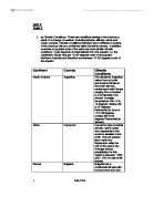
Climate in different cities around the world
Unit 3 Task 2 . a) Climatic Conditions: These are conditions arising in the world as a result of a change of weather, including latitude, altitude, winds and ocean currents. Climatic conditions therefore vary in different countries of the world as well as sometimes within the same country. In addition, countries at opposite ends of the earth can have similar climatic conditions. It just depends on their latitude from the equator, i.e. the Caribbean, South Asia are 10-25 degrees north of the equator. Northern Australia and Mauritius are between 10-25 degrees south of the equator. Continent Country Climatic Conditions South America Argentina The climate in Argentina varies from a humid sub-tropical climate in the north with the central semi-arid Pampa ranging from a tropical to a moderately cool climate. Average temperature from -5 to 14 degrees Celsius (23 to 57 degrees Fahrenheit) in June to 17 to 29 degrees Celsius (63 to 84 degrees Fahrenheit) in January. Africa Cameroon Cameroon has a tropical climate, which varies from equatorial in the south to sahelian in the north. The wet season lies in April and September while the rest of the year is dry. Average annual precipitation for this region is between 1,000 and 1,750 mm (39 to 69 inches). Europe Bulgaria Bulgaria has a continental climate with hot summers and cold winters. Average annual precipitation is 630
Deforestation. Cause for concern?
Deforestation. Cause for concern? Deforestation is... The definition of deforestation is the removal or damage to vegetation in a forest to an extreme extent. Deforestation is a slow-onset disaster that may contribute to other fatal disasters; it will reach catastrophic proportions after large areas of forest are damaged or removed. Slash and burn farming... A lot of the blame for tropical forest destruction can be shifted to slash and burn farmers. Slash and burn farming is where a clearing in the forest is made by cutting down trees and burning the stumps. Then the farmers grow crops for a few years until the soil fertility dissipates, then they will move onto a new patch of land. Africa... In Africa 5.5 million acres of open woodlands are cleared each year, and the vegetation of other woodland areas in the country are also declining. The forest in many areas in west Africa like Madagascar are disappearing fast, yet the rain forests in parts of central Africa have hardly been touched. The Ivory Coast has lost nearly 70% of the forest in which it started with in the 20th century. In the 1970's nearly 10% of forest was cleared each year Asia... Asia once used to be a major, dominating timber exporter, yet in 1977 it was predicted that within just 12 short years' Malaysia's forests would be severely depleted, the prediction also stated that by 1990 the timber
On Wednesday 16th October 1987, some of the strongest winds to ever have been recorded in England tore through the country leaving a path of destruction, devastation and demolition behind it.
On Wednesday 16th October 1987, some of the strongest winds to ever have been recorded in England tore through the country leaving a path of destruction, devastation and demolition behind it. Warnings of high winds had been issued two days before, but nobody foresaw such annihilation. This storm was the worst to hit South East England since 1703, and will be the worst for 100's of years yet to come. And the cause of this storm? A severe depression in the weather system. In basic terms, a depression is a low pressure weather system which bring periods of unsettled weather with them. Each side of a depression is a front, and on these fronts (one warm, one cold) the weather is at its worst. A front is lying above South East England causing the most awful weather conditions there. And in this case, extremely unsettled weather with unpredictable affects. The storm developed so rapidly that the track and ferocity of the storm was not able to be predicted. As it became so apparent that was not a normal occurrence in our maritime temperate climate, severe warnings were issued to the Emergency Services across the country. The following events are main events leading up to the Great Storm: 1th Oct - High Winds and heavy rain have been forecast for the weekend. 5th Oct, 12:00, Depression expected to track along the English Channel, producing "Fresh to strong winds". 5th Oct, 21:30,
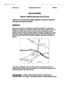
What Are the Relationships Between Atmospheric Conditions At Bradfield and Larger Scale Weather Systems?
GCSE COURSEWORK Weather in Bradfield and across the British Isles "What are the relationships between atmospheric conditions at Bradfield and larger scale weather systems?" Introduction The aim of my project is to investigate the comparison of weather at a local scale at Bradfield to a larger scale of the national weather. I have reason to predict that the local reading of the weather will be similar to that of the national reading of the weather because the situation of were the national reading is recorded is only about 10-15 miles away. I will be taking readings and studying the microclimate around Bradfield on the 29th, 30th November and the 1st of December. Bradfield is situated in the southeast of England. Great Britain is affected by two main weather systems which both have their own conditions such as rainfall, temperature, pressure. I will now describe and explain what anticyclones do and in what form the come. Anticyclones are regions of high atmospheric pressure; anticyclones are commonly referred to as "highs." The pressure gradient, or change between the core of the anticyclone and its surroundings, combined with the coriolus effect, causes air to circulate about the core in a clockwise direction in the Northern Hemisphere and an anti-clockwise direction in the Southern Hemisphere. Near the surface of the earth the frictional drag of the surface on the

With rapid urbanization, increase in human activities is always regarded as the cause of desertification due to over-grazing and over-cultivation. Discuss.
Geog Summer Assignment- Essay Question 4 Stella Kwok (7) With rapid urbanization, increase in human activities is always regarded as the cause of desertification due to over-grazing and over-cultivation. However, human impact is not the factor alone. Though men somehow alter the microclimate, the unstable global climate in the natural environment also leads to desertification. To check the spreading of desert area, some soil conservation measures and afforestation projects are carried out to stop it getting more serious. Desertification refers to the desert expanding, slowly taking in land previously not a desert. The once green landscapes dry out and there is a change in the ecosystem. The land is deteriorating and land productivity decreases, usually at the marginal semi-arid area of the desert. Take Sahel region in Sahara as an example. Desertification is a part of climatic change, which is a natural process that has been taking place continuously throughout the history of the Earth. Over hundreds of millions of years, there have been huge variations in the climates of all parts of the world. It is especially obvious in desert area, where the annual rainfall gradient is very steep, so the rainfall is highly unreliable. Desert climate is thus not stationary, but fluctuating. Between 1968 and 1974, prolonged drought occurred in the countries in Sahel. The
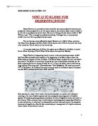
WHO IS TO BLAME FOR DESERTIFICATION?
WHO IS TO BLAME FOR DESERTIFICATION? Desertification is a process by which land that was once productive becomes non-productive. Once productive is not the natural deserts, the climatic desert where rainfall is so low that no productivity can be there. But we are talking of areas where rainfall is 300- 500mm a year. This is enough to produce something. Although now, in some places rainfall is so low that no productivity can occur. The world areas worse affected by desertification are in West Africa, countries like Mauritania, Senegal and Mali, South Africa, South west of North America and many other countries. This is shown on my world map. In my case study area of Africa, the region worst affected is the Sahel in central North Africa. My map of North West Africa shows the countries affected. Desertification is happening mainly in semi- arid areas (average annual rainfall less than 600mm) bordering on deserts. It is happening in the Sahel region where the Sahara deserts margins are near the Sahel. The Sahara desert margins can turn into desert very easily. The Sahara is sometimes "pictured as a sea of sand dunes washing into the Sahel exposing farmers to waves of sand that roll in from the desert, yearly swallowing large chunks of farming land" ('Desertification' Nick Middleton). But sand only covers 1/7th of the Sahara. In the Sahel (the semi-arid area south of the Sahara
Explain the role of human activity in producing plagio-climax communities
Explain the role of human activity in producing plagio-climax communities A plagio-climax community is Plagio-climax communities are a natural succession altered by human activity often affecting species in an ecosystem. There are many reasons in which humans can affect plagio-climax communities. Humans can greatly affect how plagio-climax communities produce Firstly human disturbances in the rainforest can cause dramatic consequences. Pulp plantations can cause plagio-climax communities by removal of forests for use in paper making industry, the trees are then replaced with Rapid growing trees which are not native to the rainforest but . This means that original trees and shrub layer will be altered and nutrients from the soil replaced only in small quantities. For example in the Amazon rainforest thousands of acres of forestland are cut down for pulp. These species are then cut down and replaced by fast growing trees which produce better profits. Another example is the Amazon rainforest again where shifting cultivation occurs. Shifting cultivation is one of the main causes of plagio-climax communities. The removal of plants for ranching and crop growing means that the rich fertile soils are used and then farmers move on to land when fertility is lost. As no organic material is added back to the soil the ground becomes less fertile and only grass and plants that require


