Tonight's News - Main Headlines - News on 'Hurricane Michael'.
Tonight's News - Main Headlines. News on 'Hurricane Michael' 'Hurricane Michael' hit southern England in the early hours of yesterday morning. The storm developed rapidly that weather forecasters over England were unable to predict the track and intensity of the storm. As soon as the weather conditions were recognised severe warnings were given to emergency services. The storm during the early hours of yesterday & through to today was the worst & the most devastating to effect the south east of England since 1703. The storm has left damage to the countryside, cities & towns. The south east of England has suffered severe damage and ships have been driven on to shore. 18 people died as a direct result of the storm damage. Yesterday's 'Hurricane Michael' caused destruction to many, Kent being the worst effected county. Fallen trees & electric cables have blocked many roads. Causing major & minor traffic congestion. All main airports have been closed until this evening due to the storm. Anglian railway has been closed until further notice due to blocked tracks, which at this moment are being cleared by fire fighters & volunteers. Meanwhile, in Dover, a ferry has been brought ashore by last night's weather, thousands of pounds are due to be spent moving it. And in the Isle of white a major tourist pier was flattened, constructors say that the damage is too
The tropical rainforest is earth's most complex biome in terms of both structure and species diversity.
Geography Tropical forest The tropical rainforest is earth's most complex biome in terms of both structure and species diversity. Climate: Mean monthly temperatures are above 64 ° F; precipitation is often in excess of 100 inches a year. There is usually a brief season of reduced precipitation. In monsoon areas, there is a real dry season, but that is more than compensated for with abundant precipitation the rest of the year. Vegetation: A vertical stratification of three layers of trees is apparent. * A layer: Widely spaced trees 100 to 120 feet tall and with umbrella-shaped canopies extend above the general canopy of the forest. Since they must contend with drying winds, they tend to have small leaves and some species are deciduous during the brief dry season. * B layer: a closed canopy of 80-foot trees. Light is readily available at the top of this layer, but greatly reduced below it. * C layer: a closed canopy of 60-foot trees. There is little air movement in this zone and consequently humidity is constantly high. * Shrub/sapling layer: Less than 3 percent of the light intercepted at the top of the forest canopy passes to this layer. Arrested growth is characteristic of young trees capable of a rapid surge of growth when a gap in canopy above them opens. Ground layer: sparse plant growth. Less than 1 percent of the light that strikes the top of the forest
Peri-glacial areas
a) Outline the main physical processes at work in a peri-glacial area (5) b) Explain how these processes produce distinctive landforms (10) c) How do peri-glacial environments present a challenge to human activity (10) a) Outline the main physical processes at work in a peri-glacial area Currently 20% of the earth is peri-glacial; therefore we can assume that 20% of the earth's processes are peri-glacial. The dominant process is that of freeze thaw weathering, which occurs due to fluctuations in temperatures around 0°C, these fluctuations can occur periodically in seasons, or variations between day and night variations. Freeze thaw is concerned with the fact that as water freezes, it expands by 9% exerting pressures of up to 2100kg/cm3 on the rock and that most rocks can only withstand pressures up to 210kg/cm3, the splitting of the rock by freeze thaw action is known as congelifraction. Frost heave is yet another process whereby water freezes in the soil and physically pushes the surface upwards; there are three criterion which need to exist for frost heave to occur, . A sufficiently cold climate to allow freezing temperatures to penetrate below the surface 2. A supply of water from below, above or laterally into the freezing zone. 3. A soil material that is frost susceptible and is lying within the freezing zone. The heaving itself is caused by the formation of
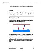
Experiment to Compare the Percentage Area Covered by Lichen on Gravestones and the Age of the Gravestone
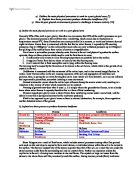
Experiment to Compare the Percentage Area Covered by Lichen on Gravestones and the Age of the Gravestone Abstract The aim of this individual study was compare the amount of lichen found on gravestones in a graveyard and the first stated age printed on the gravestone. The initial hypothesis was that the older the gravestone, the higher percentage coverage of lichen. In this experiment 20 samples were taken at random out of a field of 87 gravestones in an open graveyard at Chaldon Church in Coulsdon, Surrey. The results collected will be collated into a spearman's rank statistical test and analysed. Plan Hypothesis There will be a higher percentage coverage of lichens present as the age of the gravestones increase. Variables The aspect of the gravestones. Whether the gravestones would be covered by shade at any time. The geology of the gravestone The size and type of the gravestones. The age of the gravestone The amount and type of lichen found The aspect of the gravestones, although not a problem in the case of the graveyard I will be measuring could have caused some concerns. In the Case of Chaldon Church the graveyard is completely open on the east side of the church. The whole grounds are part of the graveyard but other sections such as to the west and south were covered by the church or trees. All gravestones face east and so it is easy to control the

Explain the main climatic conditions associated with tropical monsoon climates.
Explain the main climatic conditions associated with tropical monsoon climates The monsoon is the reversal of wind and pressure, which gives marked seasonal rainfall. The tropical monsoon climate consists of three main seasons. The tropical monsoon climate is unique to other climates, because it has a very dry season; this can be from just one month, to five or six months with no or very little rain. The three seasons are the very hot dry season (March until May), the hot, wet season (June until September), and the warm, dry season (October until February). The tropical monsoon climates are in India, Indonesia, Australia, Burma, Thailand, Ivory Coast, and Liberia. The monsoon is mainly on tropical coastlines, approximately 10 - 20 degrees latitudes both north and south. These areas normally get a similar amount of rainfall as the rainforests, but they are more seasonal, as in the wet season normally there is 80% of the annual rainfall. However the temperatures show little seasonal variation. The hot wet season is also known as the summer, south-west monsoon. The summer monsoon in India is caused by the sun being overhead in the northern hemisphere, and because the ITCZ (inter-tropical convergence zone, which is a broad area where tropical air flows meet) and equatorial low pressure move northwards. Thermal low pressure develops over northern India due to intense heating of

Discuss the weather patterns associated with and possible causes of 'El Nio' events
Discuss the weather patterns associated with and possible causes of 'El Niño' events El Niño is defined by NOAA (2005) as a disruption of the ocean-atmosphere system in the tropical Pacific having important consequences for weather and climate around the globe. El Niño events are major temperature fluctuations in surface waters of the tropical eastern Pacific ocean and are more formally known as the El Niño - Southern Oscillation. The name El Niño is derived from the Spanish 'the little boy', which refers to Christ child, due to the fact that the phenomenon is usually noticed around Christmas time in the Pacific ocean off the west coast of Peru and Ecuador. These effects were first described in a journal article of 1923 by Sir Gilbert Walker. El Niño events have historically occurred at irregular intervals of approximately 3-8 years (Caviedes, 2001) and have usually lasted one or two years. However El Niño conditions occur in most years but normally only lasts for a few weeks to a month or more, after which normal weather patterns return. The effects of major El Niño events on climate in the southern hemisphere are profound and the repercussions can be identified virtually globally. La Nina is the opposite of El Niño and is characterized by unusually cold sea surface temperatures in the eastern equatorial Pacific. The La Niña condition often follows the El
Outline the challenges and opportunities for human activity in present peri-glacial environments
Outline the challenges and opportunities for human activity in present peri-glacial environments The term peri-glacial means near to or on the fringe of an ice-sheet. This term is however more widely used to include any area that has a cold climate or areas that have experienced severe frost action in the past. Today the main peri-glacial areas are in the artic regions of Canada, USA and Russia. Frost and snow have a major impact on the landscape in these areas hence resulting in potential opportunities and in some cases, challenges. Peri-glacial areas can be further inhibited as they are characterised by a layer of permafrost or permanently frozen ground. Peri-glacial areas present many problems for settlements and therefore it is logical that most peri-glacial areas are sparsely populated and largely underdeveloped. This climate has six months of long, dark and very cold winters, with temperatures staying well below freezing for almost half of the year. During the short summer the temperatures are warm enough for plants to grow. People who live in this area rely on caribou, fish and marine mammals for food. Water in the soil below the surface remains frozen throughout the year therefore vegetation growth is minimal and limited to only mosses, lichens and low shrubs. Water is unable to drain through the permafrost and therefore the land remains wet. This is however good as

Distinguish between the terms active layer and permafrost.
Distinguish between the terms active layer and permafrost Permafrost is the name given to ground (soil or rock) that remains at or below 0ºC for at least 2 years. It is usually perennially frozen and it underlies about 20% of Earth's land surface. Continuous permafrost implies MAAT c. <-6oC to -8oC whereas Discontinuous permafrost implies MAAT c. -1oC to -8oC. Permafrost is characterised by several different things; frost shattering of material, growth off ground ice (upheaval displacement), accelerated wind erosion (high wind, low vegetation cover), thermal erosion by fluvial activity, gelifluction (down-slope flow of soil saturated by meltwater from thawing ice) and solifluction (mass wasting by combination of gelifluction & freeze-thaw). Permafrost may extend 1m to less than 400m below the surface. On the surface of permafrost is a layer which is frozon in winter but thaws in summer called the active layer. There are some key features of an active layer. When melting occurs, because the frozen ground beneath is impermeable, the active layer becomes waterlogged. Flows become major processes in this mobile layer. With the onset of winter, freezing progresses from the surface downwards. Unfrozen mobile materials are therefore trapped under increasing pressure and become contorted. Melting ice and snow lead to high stream discharges in the short summer. Explain the role of
Essay on Tractor by Ted Hughes
Essay on Tractor by Ted Hughes I've been studying a poem called Tractor by Ted Hughes. I am about to discuss how he makes the weather seem interesting throughout the duration of the poem. This poem is about a tractor, a man and the battle against the weather. The tractor is hopelessly wedged under the snow and the man is repeatedly trying to start up the tractor but in vain as the weather defies this almost disallowing. It's being defeated and progresses no further. The tractor is affected by the weather as in the first stanza it is referred to as being in agony which makes it seem alive as though it could breath, this is an example of personification which he uses throughout the poem to add effect of it seeming to be alive. It says 'snow packed it's open entrails', meaning the snow has filled up the inside of the tractor and it's described as though it were a person via the word 'entrails'. It is so cold outside that 'a spill of molten ice', smoking snow pours into its steel', which suggests that the cold air is rising off the steel. In the poem it also says 'at white heat of numbness it stands'. The word 'heat' is used in this instance because the freezing temperature makes it seem as though the tractor has frost bite which makes it seem hot, this is a form of personification. The fact that Hughes adopts personification and uses it to describe the tractor makes the
Extreme Weather Event: Tropical Cyclones in Bangladesh
Extreme Weather Event: Tropical Cyclones in Bangladesh Introduction: In this report I will investigate the problems of tropical cyclones, and I will concentrate on the country of Bangladesh. I am using Bangladesh as the country for my report because it is a perfect example of what a tropical cyclone is capable of on flat land. What are tropical cyclones? A tropical cyclone is a very violent storm which is produced over warm tropical oceans which have a temperature of 270C. Below is a picture of how tropical cyclones develop. The oceans temperature is about 270C, and the arrows show that the intense heat is rising upwards. The clouds then start to form low pressure. They are like stronger versions of mid-latitude depressions. They are areas of very intense low pressure which are rotated by strong winds, cloud and heavy rain. The wind speeds can sometimes reach up to 150 km per hour. The top of tropical cyclones are usually about 1000km across. Below is a picture of a tropical cyclone breaking up. You can tell it is breaking up because the eye of the storm is no longer well developed and also, the spiral patterns of the lower clouds can be clearly seen. Below, there is another picture showing how tropical cyclones reach Bangladesh: The black arrows represent the tropical cyclones funnelling up through the ocean in the direction of Bangladesh. When they reach


