
"An investigation into the methods of coastal management along Brighton's Coastline and the reasons for them".
Md. Shahajada Chowdhury 1H 5613 Geography Coursework Mr A. Ali 0548 "An investigation into the methods of coastal management along Brighton's Coastline and the reasons for them". Contents Introduction_________________________________________________________________________4-10 Aims__________________________________________________________________________5 Coastal Management_____________________________________________________________6 Hypothesis_____________________________________________________________________6 Longshore Drift_________________________________________________________________6 Costal Damages_______________________________________________________________6-7 Coastal Protection_____________________________________________________________7-9 Hard Engineering________________________________________________7-9 Soft Engineering__________________________________________________9 Facts on Brighton_____________________________________________________________9-10 Methodology_______________________________________________________________________12-89 Data Collection______________________________________________________________15-25 Beach Profiles________________________________________________16-18 Pebble Analysis_______________________________________________19-20 Groyne Measurements__________________________________________21-22 Tourism
My pilot study and extended investigation is to be conducted at Hunt's Bay, Gower.
INTRODUCTION My pilot study and extended investigation is to be conducted at Hunt's Bay, Gower. Hunt's Bay or Deep Slade is situated on the Gower Peninsula facing south. The OS (ordinance survey) grid reference of hunt's bay, from a mumbles and south Gower map is 564 868 (see appendix 1). It is a rocky beach. The rocks are made up of carboniferous limestone, a sedimentary rock. We decided that the bedding planes at Hunt's Bay are about 45 degrees from each other, with smooth fronts due to erosion by the sea. This will affect the type and amount of sea life at the beach. Cliff face Sea 45 degrees Aim of Pilot study The aim of my pilot study is to conduct a transect of Hunt's Bay. From this, I will be able to produce a zonation pattern for the beach, draw a profile of the beach, calculate the exposure rating and discuss the distribution of various organisms found on the beach. This will help me with my extended investigation. Method for conducting a transect at Hunt's Bay The method I am going to use to conduct a transect at Hunt's Bay is the Cross-Staff method. (Refer to appendix 2) Tides A tide is a periodic rise and fall of all ocean waters, including those of open sea, gulfs and bays. The tide will rise and fall twice approximately every 25 hours, giving two high tides and two low tides daily. Tides are the result from the

Coastal Processes
Aims of the Experiment * Aims in 3 bullet points ----------------------------------------. Page 3 Introduction - Diagrams, Pictures and Photos * Picture of our residence --------------------------------------- Page 3 * Diagram of waves' energies ------------------------------------ Page 4 * Constructive waves diagram ----------------------------------- Page 5 * Destructive waves diagram ------------------------------------ Page 5 * Erosion - Corrosion/Abrasion diagram ------------------------ Page 6 * Erosion - Scouring diagram ------------------------------------ Page 7 * Erosion - Hydraulic Action diagram --------------------------- Page 7 * Erosion - Solution diagram ------------------------------------. Page 8 * Erosion - Attrition diagram -----------------------------------. Page 8 * Longshore Drift diagram --------------------------------------. Page 9 * Porlock Bay map ------------------------------------------------ Page 11 * Porlock Bay sketch --------------------------------------------- Page 12 * Porlock Bay formation ----------------------------------------- Page 13 * Picture of Porlock Bay overview ------------------------------ Page 14 * Waves formation diagram ------------------------------------- Page 14 * Photo of Porlock Bay overview -------------------------------- Page 15 * Solutions - Offshore submerging breakwater diagram -----. Page

North Stradbroke Island Report
Table of Contents Foreword 1 .0 Introduction 2 2.0 One Mile Beach: Seagrass Investigation 6 3.0 Myora Springs: Mangrove Investigation 12 4.0 Main Beach: Sand Dune Investigation 17 5.0 18 Mile Swamp Investigation 27 6.0 Brown Lake Investigation 32 7.0 Protection and Conservation of North Stradbroke Island 36 8.0 Conclusion 39 9.0 Bibliography 40 Appendix 43 List of Figures and Tables Figure 1: Transect of Seagrass 11 Figure 2: Sand dune Transect 24 Table 1: Biotic Data of Seagrass Investigation 7 Table 2: Seagrass Transect Results 10 Table 3: Biotic Data of Mangrove Investigation 13 Table 4: Biotic Data of Sand Dune Investigation 20 Table 5: Vegetation Data of Sand Dune Investigation 21 Table 6: Animal Data of Sand Dune Investigation 22 Table 7: Sand Dune Transect Results 23 Table 8: Vegetation Information for Sand Dune Investigation 25 Table 9: Biotic Data of 18 Mile Swamp Investigation 30 Table 10: Animal Survey on 18 Mile Swamp 31 Table 11: Biotic Data on Brown Lake Investigation 34 Table 12: Animal Survey on Brown Lake 35 Table 13: Impacts on the Mangrove Ecosystem and Strategies 37 Foreword On the 20th and 21st September 2006, a field trip was undertaken to Queensland's North Stradbroke Island (NSI). Five various sites were visited to help compile a suitable management plan for the protection and conservation of NSI. The five habitats observed
Investigate the effects of costal processes on Porlock Bay in Somerset and also to investigate transportation along Porlock Bay.
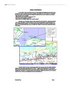
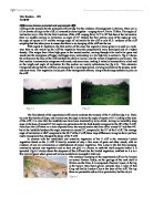
- To investigate the effects of costal processes on Porlock Bay in Somerset - To investigate transportation along Porlock Bay. Introduction Place of study - Somerset, England, Population 447,000 The maps below shows the location of Somerset and Porlock Weir in the United Kingdom - I will investigate the effects of costal processes at Porlock Bay. Porlock Bay is situated on the west coast of England. Porlock Bay is in the county of Somerset and Bristol is the nearest major city, this is shown in fig 1. Somerset is in a national park, this means that the area is protected. The national park is called Exmoor national park. The national park area is a SSI; this means that the area is a site-specific interest. The SSI area means that the area is protected and there is only limited building at Exmoor National park. Somerset is a rural county in the UK. Tourism is very important in the county of Somerset. We visited Quantock Hill in the west of Somerset. The main settlements in this area are Minehead and Taunton; this is shown in fig 3. Fig 4 shows Porlock Bay in more detail. On this map you can see Hulstone Point and Gore Point as well as local services. Minehead and Taunton are where most of the services are available. Minehead and Taunton also contains many large settlements. Minehead has more people employed, as tourism is its main source of income. Minehead attracts
In my studies I will try and determine how and why management strategies have been put in place at Brancaster in order to stabilise this stretch of coastline.
Purpose of Investigation In my studies I will try and determine how and why management strategies have been put in place at Brancaster in order to stabilise this stretch of coastline. By looking at four main objectives I will attempt to produce a holistic view of the processes taking place within the area, my lines of enquiry will include; • Why Brancaster needs managing? • What has been done in terms of management so far? • How effective these strategies have been? • What solutions or strategies might be seen within the future? Brancaster lies on the eastern coast of Britain within the county of Norfolk. Located approximately 7 miles East of Hunstanton, a major tourist town, on the A149, it demonstrates an excellent example of an area of outstanding natural beauty. The coastline itself along the periphery to the North of Brancaster town stretches for 4 1/2 miles and the area covers over 2000 acres of beach. The maps below identify the location of Brancaster... As North Norfolk currently is experiencing eustatic rises in sea level and local isostatic subsidence, localised flooding is becoming a great cause for concern. Together with being situated in an area directly within the path of North Sea Storm fetches and facing a northerly direction, the need for coastal defences and management of Brancaster's vulnerable coastline is becoming vital. Within this site

Erosion at Walton on the Naze
. CHAPTER1 As part of my GCSE coursework, my geography class and I had to visit Walton-On-The-Naze. We visited Walton on the 3rd of November 2000. I have to answer the question, 'Why is the rate of erosion so rapid at Walton-On-The-Naze?' I will try to answer this by studying a variety of coastal processes that are operating at Walton, e.g. the different types of sea defences, and use the theory behind it. I will use for example, the technical terms in my explanations with diagrams where possible. Walton is very close to the North Sea, and this is only one reason why erosion is so rapid. The cliffs have eroded by 4m since last year, and the largest amount it has eroded was 5.9 m in 1998 to 1999. The rapid rate of erosion is due to the many processes on its coast, effect of raw materials, wave size and fetch, depth and width of beach, longshore drift, where waves transport the material along the beach. Including mass movement e.g. small avalanches, rotational slips, weathering, and formation of wave cut platforms. My project will also involve lots of results from the tests we took, and evidence supporting it. In this first chapter, I will introduce Questions and Hypotheses which I will present as a list, the location of Walton, and then my aims and objectives. In most sections I will talk about the influencing factors, the technique, and the limitations and

I am going to study Camber Sands and Fairlight to see if the hypothesis that I am investigating is true, the hypothesis is: "Coastal management is more effective at Fairlight than at Camber".
Contents Page Introduction 3 Data Collection & Recording 5 Data Presentation 9 Data Analysis 40 Conclusion & Evaluation 47 Bibliography 49 Introduction I am going to study Camber Sands and Fairlight to see if the hypothesis that I am investigating is true, the hypothesis is: "Coastal management is more effective at Fairlight than at Camber". I will use different types of equipment and many skills to present my findings in graphs, tables and various other means. The two sites that I am investigating are located in East Sussex, on the South East coast of England; I have included a sketch map below to show their locations. I have circled Cliff End, as this is the exact location where I collected my data. The beach at Camber (known as Camber Sands) has been a major tourist attraction for many years, but would not be so successful if it wasn't for the schemes that managers of this coastline have put in place. The dunes at Camber are held in place with the help of marram grass, which grows on top of the sand with long roots helping to keep the surface together. Also the blades of the marram grass catch the sand to stop it from blowing back down the beach towards the sea. Dunes form where large stretches of sand are exposed at low tide and is moved up the beach by the wind as well as the process of
Herne Bay is situated along the stretch of the North Kent coast in Southeast. I choose to study this site because there are many different measures taken for coastal protection.
Introduction Herne Bay is situated along the stretch of the North Kent coast in Southeast. I choose to study this site because there are many different measures taken for coastal protection. I can get a broader range of results ending in a more accurate conclusion of the situation. The specific topic I have chosen to study is how and why do cliff and beach profiles vary along the stretch of the north Kent coast. I believe that the most well protected areas of the coast that I will study are likely to have the largest pebbles, the longest and the most level beaches. In the areas with little or no protection pebbles will be smaller if not be shingle and perhaps sand in some areas. The cliffs are also likely to be cut away from the bottom leaving them unstable and in some conditions causing slumping. It was decided after the storm of 1953, which caused disastrous flooding and wide spread destruction that Herne bay needed new improved sea defences. After some research into the matter by the local district council it was discovered that a storm of the same magnitude would return in an estimated period of a hundred years. When strong winds gather in the northern sea a factor known as the North Sea surge occurs at which time the sea level can raise up to two metres above the level of the normal waters which is what caused the catastrophic flooding in the storm of 1953. Previous
Differences between protected and unprotected cliffs
Analysis Differences between protected and unprotected cliffs Looking at the transect for the protected cliff (see fig 3:4) the evidence of management is obvious. There are in all six breaks of slope in the cliff, all reasonably close together - ranging from 4.13m to 11.86m. The angles of inclination vary a little for the first 6 sections of the cliff, ranging from 13.5º to 20º but then at the last section there is a sudden increase in inclination, an angle of 31º. Despite the final section, none of the angles go over the angle of repose at 35º and the average angle of inclination for the cliff is only 20.2º, evidence of the cliff sculpting that has taken place to ensure that there is no slumping of the cliff into the sea. With regard to vegetation, the first section of the slope has regularly mown grass as is used as a walk-way, then as one moves up the cliff the vegetation becomes progressively more developed and of a higher density. This ranges from 50cm high grass in the second section, moving through taller and taller grass and weeds into the emergence of bigger and bigger trees, culminating in a 4m high tree in section 6. Fig 4:1 shows the walkway at the base of the cliff and then the shallow incline, also the extent of vegetation can be seen. The final section is extensively overgrown with scrub, and some trees, making it virtually inaccessible to climb and so


