
The 1993 Mississippi Flood Report.
The 1993 Mississippi Flood Report History The Mississippi river is 3800km in length and flows through ten states. It receives over 100 major tributaries, including the Missouri which joins at St Louis. Its drainage basin covers one-third of the USA and a small part of Canada. Frequent flooding by the Mississippi has created a wide flood plain. The flood plain is 200km wide at its widest point, and consists of fertile silt deposited by the river at times of flood. Even before the area was settled by Europeans, the river flowed above the level of its flood plain and between natural levees. Nineteenth-century Americans considered the Mississippi to untameable and a major flood in 1927 caused 217 deaths. Since then over 300 dams and storage reservoirs have been built, the natural levees have been heightened and strengthened to protect major urban areas. The levee at St Louis is 18km long and 16metres high. Flooding continued throughout the 1950's and 60's but the last big flood was in 1973. The American public believed that due to large investments of money and modern technology, they had at least 'controlled' the river. Certainly the danger to human life had been greatly reduced but that was before the events of the summer of '93. Events leading up to the flood Heavy rain in April 1993 saturated the upper Mississippi basin. Thunderstorms throughout June caused huge surface

Mississippi Flood 1993: Case Study
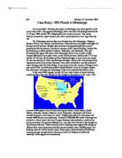
Mississippi Flood 1993: Case Study Background information : Within the USA 8% of the surface area is at risk of flooding and 35 million people live on flood plains which means that one sixth of floodplains in the USA are now urbanised however this has its problem every year between 47.6 and 89 people die due to flooding. This means that obviously the US government spends a considerable amount of money on flood defences $9000 is spent on flood control every year and $300 is spent on forecasting alone. This brings me to my case study on the Mississippi floodplain; it is the fifth largest in the world and is 3,211,000 km2 in area. The river alone drains over 585 million tones of sediment per year. The Mississippi lies just above the Mississippi river delta in the gulf on Mexico and has many meanders; now like many floodplains it also has a large "corridor" of development down the bottom of the valley when urbanisation has occurred. Before this urbanisation had occurred the floodplains mainly consisted of fertile silt, which was deposited by heavy times of flooding. Bellow is a diagram of he exact location of the Mississippi: Cause of the flood in 1993: Like many floods this flood was caused by large amounts of precipitation over a long period of time, in June and July of 1993 much of the area experienced over 150% of normal rainfall and parts of North Dakota, Kansas and

Case Study: The Mississippi River Flood of 1993
Case Study: The Mississippi River Flood of 1993 This project describes the characteristics of the most devastating flooding disaster in U.S history, the 1993 Mississippi River flood after reading this case study you should know: * What is the definition of a flood? * Facts about the Mississippi River * How large an area was affected by the 1993 Mississippi flood? * Why did flooding occur? * How was the flood event related to regional weather patterns? * What is the difference between the upper and lower Mississippi? * What is the difference between prevention and adjustment? * How were levee systems affected by the flooding? * How are dams used for flood control within the Mississippi River basin? * Did most of the residents of the floodplain have flood insurance? * How did flooding affect people and the economy of the Midwest? Introduction A flood is defined as the temporary overflow of a river onto adjacent lands not normally covered by water. The most devastating flood in U.S. history occurred in the summer of 1993. * The Mississippi River at St. Louis, Missouri, was above flood stage for 144 days between April 1 and September 30, 1993. * Approximately 3 billion cubic meters of water overflowed from the river channel onto the floodplain downstream from St. Louis. * All large Midwestern streams flooded including the Mississippi, Missouri,

The Mississippi floods
The Mississippi floods One of the largest floods n the Mississippi was in the summer of 1993. * The Mississippi River at St. Louis, Missouri, was above flood stage for 144 days between April 1 and September 30, 1993. * Approximately 3 billion cubic meters of water overflowed from the river channel onto the floodplain downstream from St. Louis. * All large Midwestern streams flooded including the Mississippi, Missouri, Kansas, Illinois, Des Moines and Wisconsin rivers. * Seventeen thousand square miles of land were covered by floodwaters in a region covering all or parts of nine states (North Dakota, South Dakota, Nebraska, Kansas, Missouri, Iowa, Wisconsin, Minnesota, and Illinois). The Mississippi river basin had two parts to it the upper basin and the lower basin. These two areas are located on the map shown above but Flooding was confined to the Upper Mississippi because the river channel widens considerably south of Thebes, and the Lower Mississippi received lower than average inflow from tributaries. The floods were caused by a weather system coming in from the Gulf of Mexico. This front is shown in this diagram. The Effects of The Floods were: It was excellent for the farmers on the Mississippi flood plain. The floodwater made the soils again rich and fertile. However there were a variety of problems. In the Short term crop production dropped by up to 10%, A
1993 Floods in Mississippi
h/w Monday, 25 November 2002 Case Study: 1993 Floods in Mississippi For an incredible 144 days, the people of Mississippi, but more specifically St. Louis lived in fear. The gigantic Mississippi River was above flood stage between the 1st of April 1993 and the 30th of September later on the same year. The events between created the largest floods in the USA and devastated an area larger than the UK. The Midwestern streams that were flooded were the Mississippi, Missouri, Kansas, Illinois, Des Moines, and Wisconsin. These streams rose higher and higher by the day, but the National Weather Services had already predicted below normal precipitation for the summer, but above average rainfall meant flooding. Despite this, the first heavy rainfalls started in Dakota, Wisconsin, and Minnesota. This was followed by the upper 200 miles of the Mississippi River to be closed to traffic. Around 100 homes were under water, as the first dams burst. Between the 5th of June and the 16th of June, the Keokuk and Fort Madison bridges in Iowa had to be closed. As were the Quincy II, Alton and Burlington bridges. By now the river had spread an impressive seven miles inland. However, even more remarkable, was the amount of water flowing under the Eads Bridge. It was eleven times the volume of Niagara Falls, and could fill the world famous baseball Busch Stadium every 65 seconds.

River Mississippi
RIVER MISSISSIPPI Hydrosphere A Case Study of * River management * People interfering in the hydrosphere * A flood management scheme River Basin / Catchment area The source of the river is the eastern side of the Rocky Mountains and the Appalachian Mountains to the north. There are many hundreds of tributaries including the Red River, Missouri river and the river Ohio. The mountains form the river's watershed. From Minneapolis the river flows South-East into Iowa where it flows south as far as Davenport. At Davenport it is joined by more small tributaries. From Davenport it meanders South to St. Louis, where it is joined by the Missouri. It then flows South-East, to be joined by the Ohio. It then flows 400 km before being met by the Arkansas river. It then flows South through Louisiana, to the Gulf of Mexico, where it splits into the many distributaries of its delta. How is the Mississippi controlled ? How & why used ? Benefits Problems Levees Mounds of earth are built parallel to the river, along its banks. These contain the rising river in flood times and protect buildings along the valley on the flood plain behind. * Known & successful technology which follows nature (rivers deposit silt to build natural levees anyway) * Protect settlements * Allow land close to the river to be used for economic gain * Concrete levees are a barrier to the
Flooding on the Mississippi
Flooding on the Mississippi Causes, effects, consequences & management. Background: The Mississippi river is situated in the USA and flows through ten states; Minnesota, Wisconsin, Iowa, Illinois, Missouri, Kentucky, Arkansas, Tennessee, Louisiana, Mississippi. In total the Mississippi river covers 3733km. The drainage basin conditions of this river vary from day to day. That is why this river is very unpredictable. Causes of the 1993 flood: . Starting as early as the fall of 1992, heavier-than-usual rain and melting snow saturated the soil with moisture. When seasonal rains and snowmelt came in spring 1993, the water ran off into streams because it could not soak into the ground. So streams were already swollen when a rain-producing weather system stalled over the Midwest in June 1993, and unusually heavy rains fell in many places - often twice the normal summer amount. The rains lasted through August. 2. The waters overwhelmed the normal river channel, so serious flooding hit Illinois, Iowa, Minnesota, Missouri, and other states in the Missouri and upper Mississippi basins, an area 500 miles long and 200 miles wide. 3. Urbanisation on the flood plain was also a major factor as grass and tress have been covered over and concrete and tarmac. Replacing a permeable surface with an impermeable one has many effects on the river. Movement (transfer) of water into the

River Management Case Study on The Mississippi.
Assignment 5 - River Management Case Study For a named river basin a. outline the ways in which this river has been managed by man b. explain the effects this has had upon the rivers features and processes. The River Mississippi: The Mississippi along with the Colorado is one of the most managed rivers in the world. It is one of the longest rivers in the world as it stretches 3800km across North America from Canada to the Atlantic Ocean. Along this very long stretch much management has taken place. Even though the management of the river isn't as great as the Colorado its importance economically is much greater. The watershed of the Mississippi occupies 41% of the USA so its importance is huge. Flooding of the Mississippi would mean huge economic and environmental damage so there is great necessity to manage it to a great degree. The river is used for navigation to export 60% of all grain in the USA. Many large cities rely on the Mississippi for their water supply. But the use of the river for water has bad effects. There is great risk of flooding in these cities, a bit of a double edge sword. The worst of this flooding was in 1993. The Mississippi has been adapted and managed much throughout history and has accounted for the growth of major cities along its path. The Mississippi is very unique as the management is present all along its 3800km path, which for a river

Mississippi
Mississippi, with the picturesque river, magnolia scented evenings, and antebellum mansions is the quintessential southern state. However, there is much more to this, our 20th state, than confederate attitudes and racial tension. "The state never adopted progressive ideas or embraced social change with any enthusiasm. History made Mississippi a conservative place." (Woodard, 2006) Organized on April 7, 1798, from territory ceded by Georgia and South Carolina, Mississippi expanded twice to include disputed territory claimed by both the U.S. and Spain. Land was purchased from Native American tribes from 1800 to about 1830. Mississippi was admitted to the Union December 10, 1817. Mississippi became the second state to secede from the Union on the cusp of the Civil War, January 9, 1861. Briefly forming the Republic of Mississippi, not one Mississippian voted in favor of Abraham Lincoln. Mississippi ranked as the third largest slaveholding state in the nation with nearly 437,000 slaves. This represented slightly more than half of the state's total population. "From 1810 to 1820, the enslaved population on the Mississippi frontier grew by more than 90%. The span of 1830 to 1840, Mississippi's white population grew by a whopping 154%, while the state's slave population grew by 197%." (Mississippi Slave Laws Summary and Record , 2004) The slaves in Mississippi mainly
Three Lives of Mississippi
Linh Nguyen HIST 1302- M-W: 9:30 am Pro: Baines Alton R. Three Lives of Mississippi Mississippi was a center of the American Civil Rights Movement and especially captured the national stage in 1963 and 1964. Few white leaders in the state supported the effort to secure voting and other rights for African Americans. Over this book is the only complete on-the-scene account of the heinous Freedom Summer murders in Mississippi. According to Martin Luther King, Jr: "This book is a part of the arsenal decent Americans can employ to make democracy for all truly a birthright and not a distant dream. It relates the story of an atrocity committed on our doorstep." In the civil rights movement, 1964 was the year of Freedom Summer. On June 21, Mississippi, one of the last bastions of segregation in America and a bloody battleground in the fight for civil rights, reached the low point in its history. Three young civil rights workers-a 21-year-old black Mississippian, James Chaney, and two white New Yorkers, Andrew Goodman, 20, and Michael Schwerner, 24-were murdered near Philadelphia, in Nashoba County, Mississippi. They had been working to register black voters in Mississippi during Freedom Summer and had gone to investigate the burning of a black church. They were arrested by the police on trumped-up charges, imprisoned for several hours, and then released after dark into the


