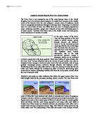
Landforms located along the River Tees, County Durham
Landforms located along the River Tees, County Durham The River Tees is not necessarily one of the most famous rivers in the United Kingdom, but in its relatively short passage to its mouth from its source in the marshy moors of the Pennine Hills, the river produces a diverse array of landforms, which vary as it progresses downstream through its drainage basin. Beginning in a saturated moor as a mere trickle of water over 600m above sea level, it emerges progressively larger, producing waterfalls, gorges and V-shaped valleys with interlocking spurs in its upper course, meanders and oxbow lakes in the middle course and flood plains, levees and deltas as it reaches its mouth. In the upper course of the River Tees, the steep gradient of the land results in vertical erosion, mainly through abrasion and hydraulic action to be the dominant process occurring with the river at this stage. The Tees starts from its source in a saturated moor in the Pennine Hills. The abundant water trickles downwards, due to the high gravitational potential energy it possesses, which can be converted to kinetic energy due to the steep gradient. These mere trickles of water develop into the River Tees. Various tributaries add to the volume of water and the river uses its abundant kinetic energy to vertically erode away at the bed and banks, with its steep gradient encourages erosion vertically
River Landscapes and Processes
River Landscapes and Processes Some important words and definitions: . Fluvial Landscape - a landscape created by rivers and their tributaries. 2. Tributary - a small river or stream which joins to a larger one. 3. River or drainage basin - an area drained by a single river together with all of its tributaries. 4. Confluence - where 2 or more streams, rivers or tributaries join together. 5. Watershed - The boundary line between different river/drainage basins. (Sometimes these are referred to as Catchment areas) 6. Source - The starting point of a river or stream. (watercourse) - This maybe a spring or just an area of boggy/marshy land. 7. Channel - the space between the banks of the watercourse in which the river flows, and may vary form a few meters to hundreds of kilometres. 8. Mouth - the point at which the river enters the sea or a lake. 9. Delta - the mouth of a river that splits into many channels (or distributaries) e.g. The River Mississippi or the River Nile. 0. Long Profile - the cross-section of a rivers course from its source to its mouth. 1. Cross Profile - a section across the valley of the river at any given point. How Do Rivers Shape The Land? There are 4 main processes by which a river can cause erosion (wearing away) and 4 processes by which a river can transport (move) material. * Processes of erosion . Attrition - breaking up of material
Introduction to study of the River Shuttle.
Introduction to study of the River Shuttle. This geographical report will focus on the changes in the characteristics of the River Shuttle as it flows down stream. The River Shuttle is approximately 6.3km in length. It flows from New Eltham (grid reference 443 737, landranger 117 0rdnance survey map), through Bexly where it flows into the River Cray (501 702.) The aim of this investigation is to test three hypotheses. .) The velocity of the river increases as it moves down Stream. 2.) Bed load calibre decreases as you move down stream. 3.) There are no significant differences in the channel characteristics of a small river as it moves down Stream. Methodology. These hypotheses can be tested using several methods. Although the methods used are not completely reliable, due to lack of professional equipment, they can still give a fairly accurate reading for each hypotheses. Velocity was tested by timing the length it takes for a small and light object to travel over a 5m stretch at each site. Bed load calibre was tested by measuring five random pebbles from within the river, using callipers and taking an average. As a way of testing significant differences in the channel characteristics as we moved down stream we measured the depth, width and amount of water of the river channel. Site one. Site one is situated extremely close to the source of the river shuttle.
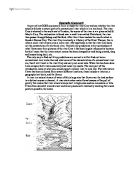
Study the river Cray and see whether the river actually follows a natural path of a conventional river which is in a text book.
Geography Coursework As part of my GCSE coursework I aim to study the river Cray and see whether the river actually follows a natural path of a conventional river which is in a text book. The river Cray is situated in the south east of London, the source of the river is at a place called St. Mary's Cray. The mid-section is found near a small town called Chislehurst; the river then passes through Sidcup and Dartford. After this it then reaches the mouth which is found at Barnes Cray. The river Cray is actually a tributary of the River Thames; this is when a small river stream joins a main river. My hypothesis is that the river Cray does not the conventions of a text book river. I believe my predictions to be true because of what I have seen from pictures of the river Cray it has been largely influence by humans by this I mean that the rivers natural course has been changed by road being created, shop and houses being built, etc. The only way to find out if my predictions are correct is to first find out how a conventional river looks like and what some of the characteristics of a conventional river are, then I will travel to the river Cray and carry out some tests. When this has been done I can compare both rivers accurately and make my results. The main part of this introduction looks at what you would expect a natural river to look like. The information I have has been
Geograpgy glendun river
Contents Page 1 Front cover Page 30 Location - map showing bed load distribution Page 2 Contents Page 31 Evaluation Page 3 Section 1 - Applied understanding Page 32 Evaluation Page 4 Location Page 33 Evaluation Page 5 Location - map Page 34 Evaluation Page 6 Theory - Ideal stream Page 35 conclusion Page 7 Ideal stream table Page 36 Bibliography Page 8 We should expect to find at: Upper course Page 37 Appendix Page 9 Middle course Page 10 Lower course Page 11 Glossary Page 12 Glossary Page 13 Methodology Page 14 Equipment used Page 15 Data table Page 16 A comprehensive range of techniques Page 17 A comprehensive range of techniques Page 18 Originality Page 19 Results and analysis - Hypothesis 1 Page 21 Results and analysis - Hypothesis 1 Page 22 Results and analysis - Hypothesis 1 Page 23 Results and analysis - Hypothesis 1 Page 24 Results and analysis - Hypothesis 1&2 Page 25 Hypothesis 2 Page 26 Hypothesis 3 Page 27 Hypothesis 3 Page 28 Conclusion Page 29 Originality GCSE Geography Coursework Section 1 - Applied understanding Why? We are doing this study to test all the text book theories. It brings all the ideas that we read in a book to real life, we can see exactly what happens for ourselves we get the chance to record the results ourselves also this is a requirement for our geography GCSE and the study is worth 25% of our

River study - Burbage Brook,
Plateau The plateau is the source of Burbage Brook, which is a fairly large are of high flat land. This is formed by heavy rainfall soaking into the peat, which then filters into the brook. Upper Burbage Brook The upper area of Burbage Brook is a 'V-shape' with very steep sides. This is caused due to the steep gradient of the riverbed that then leads to a high velocity of the river causing rapid vertical erosion to take place (refer to the bar chart to explain the velocity of upper Burbage Bridge.) This combined with weathering creates a 'V-shape' valley. Deposition here is very minimal, as it is only the first flowing currents. The type of weathering that you are likely to find at this area of the valley is 'freeze-thaw weathering'. This is when water gets into the cracks in the rock, expands (freezes) which then puts pressure on the rock eventually causing chunks of the rock to break off leading to a form of mass movement (Rock Creep). Middle Course of Burbage Brook The middle course of Burbage Brook is a 'V within a V' shape. The valley is slightly wider here than the upper course of Burbage Brook also the valley sides are much gentler. It also meanders side to side caused by interlocking spurs (look at the diagram below about a meander). The valley sides widen due to lateral erosion. Lateral erosion takes place here because the velocity of the river is much
Coastal Erosion and Deposition Landforms Durdledoor, Dorset
Coastal Erosion and Deposition Landforms Erosion Landform : Durdledoor, Dorset: Durdle Door is an arch which has formed parallel to the shoreline. It has formed due to the erosion of Wealden Beds (weak easily eroded clays) and Greensand (a relatively weak limestone) being quickly eroded either side of a section of more-resistant rock, forming the headland of Durdle Door. The resistant rock is made up of two adjoining sections of Portland Stone (highly resistant limestone) and Purbeck Beds (combination of shales, clays and limstones, varying in resistance). However, due to wave refraction the headland of Durdle Door has been particularly attacked by coastal erosion. This originally resulted in small geo's and caves which have grown in size to large arches (see picture below), which then collapse leaving stacks and eventually stumps. This process of erosion on the more resistant rock is much slower than that of the less resistant rocks either side, resulting in the formation of a headland. The natural arch of Durdle Door is one of the physical features of the area which has retained a name given to it probably more than a 1000 years ago (Arkell, 1947), showing that the coast does not change very rapidly. The name " Durdle " is derived from an Old English word "thirl", meaning to pierce (as in "nostril"). A similar arched rock in south Devon is known as the Thurlestone.
"The Hydrological Study Of the River Conwy"
GCSE Coursework "The Hydrological Study Of the River Conwy" This project will study the transition of the River Conwy as it flows downstream. It will concentrate on the following variables: * Water Width * Depth * Wetted Perimeter * Gradient * Flow Velocity * Float Velocity * Stone Roundness * Stone Size Another variable we could have measured is the pH value of the water in the river. This would have detected pollution levels as it goes downstream. These 8 variables will provide us with the sufficient information. Aims The aims of the project are: . To investigate changes in the channel form and river processes at different sites downstream on the River Conwy. 2. To identify landforms associated with river processes Hypothesis The following hypotheses were tested: . Downstream, the width will increase. 2. Downstream, the depth will increase 3. Downstream, the velocity will decrease 4. Downstream, the cross sectional area will increase 5. Downstream, the discharge will increase 6. Downstream, the gradient will decrease 7. Downstream, the wetted perimeter will increase 8. Downstream, the bed load size will decrease 9. Downstream, the bed load roundness will increase. Background Information Site 1- (Nant-y-Brwyn) Ref- 792 450 Nant-y-Brwyn was the site highest above sea level and therefore the nearest to the source, which we studied. This site
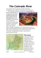
Reort on the Colorado River
The Colorado River The Colorado River is a principal river that runs through southwestern USA. It flows for 1,450 miles (2,330 km) from the Rocky Mountains to the Gulf of California, running through 7 US states and 2 Mexican states. It is a main source of water for agricultural and urban areas and an important source of hydroelectric power. As the Southwest's only significant source of water, the Colorado River was heavily developed in the twentieth century by a system of dams, reservoirs and canals. It supplies a population of 40 million people and over 29 major dams and hundreds of miles of canals serve to supply thirsty cities, provide irrigation water to around four million acres (16,000 km2), and generate more than 12 billion KWh of hydroelectricity each year. The Course The source of the river begins high in a wet meadow at la Poudre pass in the rocky mountains of western Colorado around 10’000 feet above sea level. In the upper course, it initially flows south towards Mexico and is joined by many other streams and rivers before Colorado River, southwestern USA it enters the state of Utah. Here, the river starts to widen and meander which the Colorado is famous for doing. Meanders are a series of bends in a river which are formed when the moving water in a river erodes the outer banks and widens its valley trying to find the

How a river changes from source to mouth
How a River changes from source to mouth The Long Profile The long river profile is the changes in gradient at different stages in a river's flow. In the Upper Course the flow is fast and load and water volume are slow. In the Middle Course the river starts to slow and volume increases when tributaries join the river. The river erodes at this stage and the load increases. In the Lower Course, the river slows down dramatically due the gradient being almost flat. The river deposits its load due to the lack of power and speed. The volume is the largest on the river's course. This part of a river is liable to flood. Upper course The upper course is usually found in the mountains and hills where the river rises from its source. Waterfalls and rapids are also sometimes found in this course. Water falls are caused when a river runs over alternating layers of hard and soft rock. The river in the upper course is usually fast flowing. There are lots of obstacles, stones and boulders for the water to flow over. As the river moves all the way through the upper course it cuts downwards. The steepness here is steep and the river channel is narrow. Vertical erosion in this highland part of the river creates steep sided V-shaped valleys and interlocking spurs. These are caused as the river erodes the landscape in the upper course, it winds and bends avoiding areas of hard rock.


