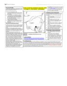
The River Ganges is a river in India. It starts at its source in the southern Himalayas
The River Ganges is a river in India. It starts at its source in the southern Himalayas and flows through China, Bangladesh, Nepal and India. The river flows through 29 cities. The darker blue on the map shows where the river flows. Pollution in the Ganges is a serious problem. Chemicals including Chromium from factories near Kanpur regularly leak out and make the river unsafe for bathing a swimming in. However this is not all bad as the Ganges has a special type of Dolphin. The Ganges river dolphin is totally blind and their eyes have no lenses. They eat shrimp and fish which are found on the river bed. The Ganges River dolphin is an endangered species because humans hunt them for oil and meat. The Ganges used to have an important use in transporting goods around and between countries. However, the construction of railways and roads has meant the river is only used to transport local agricultural products mainly tea and grain. The river has a strong religious significance. The river was named after the goddess Ganga, the daughter of mountain god Himalayas. Hindus regard the river as the most holy river and when they die, they chose to have their ashes scattered onto the river bed because they believe it will send their souls to paradise. The water supply to the river depends on the rains brought by the monsoon winds from July to October and the melting snow from the
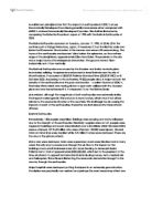
The daily lives of the rainforest people
The daily lives of the rainforest people The tribal people wear animal skin; the bora tribe wear bark cloth And the Kayapo men wear lip disks, this gives a very distinctive appearance. Most tribes live deep into the forest. The Kayapo tribe use palm leaves as roofs to their huts. Tribes catch their food by killing fish, using plant-based poisons to stun the fish. Some tribes use shotguns for hunting, others use bows and arrows, spears, or blowguns with darts tipped with curare. Shifting cultivation is an agricultural system in which plots of land are cultivated temporarily, and then abandoned. This system often involves clearing of a piece of land followed by several years of wood harvesting or farming, until the soil loses fertility. Once the land becomes inadequate for crop production, it is left to be reclaimed by natural vegetation, or sometimes converted to a different long-term cyclical farming practice. Subsistence agriculture is self-sufficient farming in which farmers grow only enough food to feed their family and to pay taxes or feudal dues. The typical subsistence farm has a range of crops and animals needed by the family to eat during the year. People in tribes consume a daily balance of protein, they would normally eat, acorns, salmon, surf fish, abalone, mussels, bulb plants, deer and small game as rabbits or monkeys. The lives of the rainforest people

There is a strong relationship between land use and coastal defences deployed. At Minster the land use is mainly open land and this is not very valuable so there is not much coastal protection in use. At Sheerness
Conclusion "The higher the land value the, the more coastal protection is used" I will now prove or disprove my hypothesis by studying the relationship between the coastal protection used at each site and the land use. What defences are there? At sheerness there is; - Revetment (figure 7) - Promenade (figure 7) - Sea wall (figure 12) - Wooden groynes (figure 12) - Flood gates (figure 13) At Minster there is; - Promenade (figure 9) - Drains (figure 9) - Used Groynes (figure 11) At Leysdown there is; - Revetment (figure 8) - Sea wall (figure 8) - Promenade (figure 8) - Groynes (figure 10) At each site the land use varied, as follows; Sheerness- The land use was mainly commercial Minster- The land use was mainly open land Leysdown- The land use was mainly residential There is a strong relationship between land use and coastal defences deployed. At Minster the land use is mainly open land and this is not very valuable so there is not much coastal protection in use. At Sheerness the land value was commercial, this is very valuable and the coastal protection shows this as it is very well protected. At Leysdown the land use is mainly residential, this type of land use is very valuable and that is why the coast at Leysdown is so well protected. There is a clear relationship between the land value and the coastal defences so my hypothesis is correct "The higher
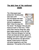
Coastal case study - Blakeney Point, Norfolk
What is it? Blakeney Point, Norfolk Describe the location of Blakeney point (where is it?) Blakeney point is located in the East of England. It is controlled by the National trust and part of the national nature reserve. How was Blakeney Point formed? Blakeney is a spit that was formed by a process called Longshore drift because of erosion along the coastal line. The process of deposition happens, the movement of sand along the coast by sea waves. That's why the lad is made of sand. Why does this need to be protected? The vast majority is made out of fine sediment deposited by waves. Salt is a major development in this land. Species that are very rare live there. Rare plants grow which can be used by scientist There is a breeding for birds such as seals. Also coastal beaches ad beautiful views of the landscape. Rare and famous shingles habitat being hold on the land. How have people affected the landform? Blakeney point now is a high touristic place. Tourists have given a lot of money which developed the land. As well as the scientist develop a lot of new thing using the rare species such as s medicine. What is being done to protect/manage Blakeney point? The land is being preserved and controlled by the national nature reserve The area is controlled for restriction of buildings The area is restricted for fishing and another human uses . CASE

Yellowstone Supervolcano
A super volcano is a mega colossal volcano that erupts at least 1,000km3 of material. Super volcanoes do not look like a volcano with a characteristic cone. Instead, they have a large depression called a caldera, often marked by a rim of higher land around the edges. Beneath the caldera is a huge magma chamber, where all the magma is stored before the volcano erupts. Yellowstone is a super volcano in Montana, North America. There is evidence that the magma beneath Yellowstone is shifting. The caldera is bulging up at one end beneath Lake Yellowstone. There are signs of increasing activity at Norris, and the ground has risen as much as 70cm in some places. The magma chamber beneath Yellowstone is believed to be 80km long, 40km wide and 8km deep. It is not known whether the magma is on top of other materials, which would be necessary for an eruption. If Yellowstone, or any other super volcano did erupt, there would be many major effects globally. An eruption is likely to destroy 10,000km2 of land, kill 87, 000 people, and 1 in 3 people affected would die. Ash would be deposited all over the United States, which would affect transport, electricity, water and farming. Harvests would disappear instantly, leaving many people hungry, and the water supplies would get contaminated, leaving hundreds of thousands of people without clean water. Global climates would change, which may

The rainforest needs your help. People are cutting down the rainforests for many reasons.
The rainforest needs your help. People are cutting down the rainforests for many reasons. * People cut down tree for mahogany, teak etc. They cut them down to fast for the rainforest to recover its former strength. * People are looking for gold, diamonds, tin & ore. They will sell this for money. * Money. An important aspect. Some people are too poor and are trying to find a job. Who suffers? * Animals suffer. They get scared, they are easy target for poachers and their homes and food & water sources are destroyed. * The soil suffers. Rainforest soil is poor. Nutrition is made from rotting leaves. When there are no trees to provide dead leaves the rain comes and washes the nutrition away. * Local tribes suffer. They have learnt to live sustainably in the rainforest. Now other men tried to force them to go. When they refused, some tried to kill them. * You suffer! Many species are being killed of every year. These include plants that could cure diseases. Burning the forest sends more CO2 into the atmosphere. This speeds up global warming. So before you buy anything, think... did this come from the rainforest in an unsustainable way? Maybe it was made of rare wood like mahogany or maybe the diamond necklace was found and dug up there. Whatever the reason, please don't get anything that has come from the rainforest unsustainably. This is our world. Save

Bradshaw model detailed description
Geography: Bradshaw model. Discharge is the volume of water that passes through a cross section per unit of time, usually discharge increases further down the river. Discharge is measured in cubic metres per second (cumecs). Occupied Channel Width is the distance across the actual channel, measured at the water surface; it increases due to increase in discharge (above), input from tributaries etc. Channel depth is the height from the water surface to the stream/river bed channel depth sees an increase further downstream along with the size of the river. A line connecting all places of greatest depth all along the river is called the "thalweg". Average velocity is the speed of the water flow (distance travelled per unit of time), it increases steadily further downstream. Further downstream, the river becomes more efficient with proportionally less contact with its bed and banks. Load quantity is the capacity of the river including the river load and it increases with discharge and velocity. Load particle size decreases considerably downstream and the more angular pebbles become more rounded due to attrition. Channel bed roughness decreases significantly downstream because of fewer and smaller stones, this is due to erosion. Channel bed roughness decreasing allows much faster water flow. The river slope angle (gradient) decreases downstream. By Liam
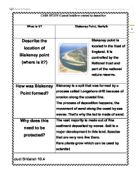
Coastal managment of Walton on the Naze
The context The problem The resort end of the Naze - 1970's integrated approach The future With Reference to a coastal area you have studied, outline the management strategies and their benefits to people and the environment? http://news.bbc.co.uk/local/essex/hi/people_and_places/nature/newsid_9084000/9084292.stm Walton-on-the-Naze Case Study of

Kobe Earthquake newspaper report
7th January 1995 BRINGING YOU ALL THE BEST NEWS 40p TERROR STRIKES AS BRIDGE COLLAPSES FIRE! SEE ALL THIS ON P
Case Study: Cardiff Bay Development Corporation, Wales.
Case Study: Cardiff Bay Development Corporation, Wales An example of: Urban Renewal /