
Hurricane Dean Report
Hurricane Dean report Name of event Hurricane Dean Where and when it happened Hurricane Dean formed on the 13th of August 2007 and eventually fully dissipated on the 23th of August. The hurricane formed over the Atlantic ocean and eventually increased in power and strength over the Caribbean sea. It eventually passed through the south of Jamaica, causing huge problems within the farming society and damaging small towns and villages spread across the country. However the hurricane also had very minor effects on countries such as Puerto Rico, Hispaniola, Cuba, Cayman Islands, Nicaragua, Honduras, Belize, Guatemala and Mexico as it passed through these countries. However the vast majority of the damage was caused in Jamaica. What caused it to be an extreme weather event Firstly, Hurricane Dean was the strongest tropical cyclone of the 2007 Atlantic hurricane season, scaling in at ‘5’ on the Saffir-Simpson hurricane scale during its peak strength. It also reached up to a max wind speed of 175mph for a sustained time of around one minute. It was also measured on its cost in damage to the countries that it effected, reaching a total of around $1.6 Billion. Hurricane Dean was also recorded to be the 7th most powerful hurricane within the hurricane seasons, coming out with the same recorded strength as hurricanes Mitch and Camille. Key impacts on people/human activities To

The Human Impacts of Tectonic Landforms & Hazards
Human impacts of tectonic activity Why live in tectonically active areas? Lack of knowledge: Even today there are people who do not understand why or where tectonic activity takes place. Tectonic activity does not only take place at plate boundaries – intra-plate earthquakes, e.g. Bam, Iran. This leads people to think it won’t happen to them. The developing world has fewer resources or expertise to study the natural environment (or human environment) – methods to identify areas at risk may not exist (e.g. poorer levels of education), especially if the area is not very active. Pompeii – a classic case of ignorance to disaster. The lack of an eruption in ‘living memory’ led many to believe that Vesuvius was dormant. In 79AD there was no expectation of an eruption – people were caught completely unaware. At the time, the science was not understood – many believed the eruption, and preceding earth tremors were the gods’ anger. Choice: Some people know the risks, but lack financial resources, or have close links to family in the area, and are therefore unable/unwilling to move. Other choose to stay, as the benefits outweigh the costs, e.g. Southern California – well paid jobs and a pleasant climate outweigh concerns over earthquake risk. The benefits of tectonically active areas: Minerals and natural resources – volcanoes bring valuable resources to
Explain why tectonic processes produce a variety of contrasting landscapes 70 marks
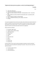
“Explain why tectonic processes produce a variety of contrasting landscapes.” 70 marks PLAN: . Wegener’s theory of plate tectonics 2. Pangea and how the earths landscape has changed globally 3. Features of oceanic plates: abyssal planes; mid ocean ridge – mountain ranges/islands; sea mounts – volcanic hotspot chains 4. Features at boundaries: ocean trenches at subduction zones; fold mountains; volcanos – volcanic island arcs; faults – San Andrea’s 5. Features of continental crust: folding of curst; Folding and faulting 6. Intrusions – tors/batholiths/dykes/sills (due to erosion/ weathering) – not by tectonics! 7. Flood basalts In my report I am going to discuss how the seven major tectonic plates move around the earth and produce the different structures found at the surface of the planet, and have resulted in varying land formations over the earth’s history. To do this I am going to use a variety of case studies to support the theories of formation and provide evidence for my argument. My case studies are as follows: . Mid Atlantic ridge/ Iceland 2. Hawaiian emperor seamount range 3. pacific abyssal plane 4. Marinas trench 5. Himalayas 6. Japan 7. San Andrea’s fault 8. Cyprus 9. Whin sill 0. Dartmoor tors 1. Siberian traps As well as evidence of how tectonic activity has shaped the landscape I will also be looking at external

Evaluate how plate tectonics theory helps our understanding of the distribution of seismic and volcanic events.
Evaluate how plate tectonics theory helps our understanding of seismic and volcanic events (40 marks) Plate tectonic theory suggests that the earth’s crust is made up of 8 main plates, as well as many other smaller ones. These plates float a top the asthenosphere and are constantly moving, thus constantly interaction with one another. This movement leads to volcanic and seismic events. Such knowledge of plate margins and their interaction can help us to understand the distribution of such events; this is because the majority of events are associated at such margins. Plate tectonics theory was initially developed in 1912 by Wegener. His report but forward the theory of continental drift, suggesting that the continents were once joined as a supercontinent, Pangaea. Plates have since moved apart, and this continental drift is what leads to volcanic and seismic events. Oceanic ridges are created when two plates diverge and magma rises between them from the asthenosere, creating new crust. This rising magma manifests itself as a volcanic event known as a fissure eruption. Plate tectonic theory aids our understanding, as it helps us to see how islands along the mid-Atlantic ridge, such as Iceland are formed. Iceland lies a top the mid-Atlantic ridge, thus was created through volcanic activity. Knowledge of tectonic theory helps us to understand why Iceland is an area of high
Chaiten Volcanic Eruption Case Study
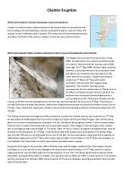
Chaitén Eruption location map for Chaitén volcano Where did it happen? (written description, map of the location) Chaitén is a small volcanic caldera (cauldron-like volcanic feature normally formed by the collapse of land following a volcanic eruption) located in southern Chile. The volcano is 3km in diameter and is located 17km west of the Michinmahuida volcano and 10km northeast of the town on Chaiten, hence the name of the volcano. When did it happen? (date, duration, sequence of events, pace of management and recovery) The largest and most recent eruption was in May 2008, but before this, the volcano consisted mainly of a rhyolitic lava dome which was last active 9400 years ago. On 2nd May 2008, Chaitén began erupting violently, producing many plumes, pyroclastic flows and lahars, and creating a new lava dome on the north side of the old dome. Chaitén continued to erupt from 2nd May to 8th May with nearly continuous ash emission and irregular large explosions. The eruption has had serious consequences for the nearby town of Chaitén due to the effect s of lahars and ash, and the ash from the eruption even disrupted travel and agriculture in surrounding countries. The plume of steam and ash rose up to 16.8km into the atmosphere on the first day, and continued to do this on the 3rd May. The plume on this day rose over the Andes Mountains, drifted over Argentina

Discuss the view that the impacts of volcanic hazards depends primarily on human factors
Discuss the view that the impacts of volcanic hazards depends primarily on human factors There are a wide range of volcanic hazards associated with volcanoes, there are the obvious primary hazards; lava flows, pyroclastic activity and poisonous gas emissions. There are also secondary impacts that result from the eruption such as lahars (sometimes called mudflows), avalanches and debris flows. These are all caused by natural causes but the effects from these can be enhanced or worsened by human factors. There are many different ways that volcanoes can impact the people and environment around it. The hazards from volcanoes can cause death to surrounding populations and also destroy important buildings and the infrastructure nearby. The environment can also be affected due to the gas released from volcanoes and also destruction of environment from pyroclastic flows or lava flows. These can be compounded and the impacts will vary depending on a mixture of human and physical factors. In 1980 in Washington State after 123 years of hibernation Mt St Helens erupted. This volcanic eruption produced many different hazards including a huge landslide, one of the largest ash clouds in recent years and a pyroclastic flow that destroyed huge areas surrounding the volcano. The most devastating of these to humans was the ash cloud. This drifted hundreds of miles and ash fell on 11 states. It

The Kobe earthquake.
This project is on the Kobe earthquake. This quake scaled 7.2 on the Richter scale (6-7 on the Japanese scale). The earthquakes epicentre was at the northern Awaji Island and had a depth of 14km. Its total deaths by the 30th of March were 5,477 and injuries 34,900. The earthquake had caused fires that destroyed 7,456 houses, road damage, 171,481 collapsed houses, and a total damage cost of 9,963 yen. In this project there is a graph showing the number of deaths over a period of days on page 2. It shows the increase of the deaths as the days went on. On page 3, the increase of the deaths is described and explained. It shows of reasons why there would be an increase in deaths. On page 4, the effect on the economy is explain and the reasons why are stated. On page 5, a letter written after the quake is enclosed, explain what had and has happened. As the days went on there was an increase in the number of deaths. This was because as the days went on more people died. The increase between the 17th and the 21st of January was a rapid increase from 1247-4412 with a difference of 3165 people. This was within 4 days which the average per day is about 1100 people. The increase between the 21st and the 18th of feburary was not as rapid. From 4412 it rose to a number of 5390 with a difference of 978. The increased really slowed down between the 30th and 18th of February, we can

The Kobe Earthquake.
INTRODUCTION On the 1st of September 1923 Japan suffered its worst ever natural disaster when an earthquake followed by a tidal wave and fire struck Tokyo. The effects were devastating, 99,331 people were killed and 103,733 people were injured. After this event took place every Japanese citizen was issued with a box of essentials in case another earthquake should strike. In addition to this, they were all given a small amount of training and, in more recent times, 500 researchers have been working to predict if and when this could happen again. Despite this, in 1995, an event took place that shocked observers worldwide. KOBE The South-central region of Japan is the second-most populated and industrialized area, after Tokyo, with a total population of about 10 million. Kobe on its own has a population of about 1.5 million and is very economically developed. Kobe is one of the richest cities in the world, producing as much wealth on its own as Canada! The Japanese built their houses traditionally out of wood here as wood was flexible and could bend with the ground if an earthquake took place. In modern times heavy tile roofs were put on top of their houses to sustain the strong winds which blew against them. THE KOBE EARTHQUAKE On the 17th of January 1995, at 5:46am local time, in the South-central region of Japan, Kobe was just beginning another new day. Suddenly a
Measuring the Intensity of Earthquakes.
General An earthquake is a shaking or trembling of the crust of the earth caused by underground volcanic action or by the breaking and shifting of rock beneath the surface. The volcanic action and shifting rocks create strain which continues to build to a sudden release of pressure resulting in a shock wave. The vibrations produced in the crust can vary from barely noticeable to enormously destructive. Shock waves can be classified into two broad categories. Waves that send particles oscillating back and forth in the same direction as the waves are traveling are called primary. Primary waves, sometimes called compressional waves, travel through the earth beneath the crust. Secondary waves cause vibrations which move perpendicular to the wave. These waves travel on the surface of the earth and move much slower than primary waves. Thus, when an earthquake occurs, seismic centers throughout the world record primary waves before the secondary waves arrive. Historical Overview Earthquakes have captured the imagination of people living in earthquake prone regions since ancient times. Ancient Greek philosophers thought quakes were caused by subterranean winds, while others blamed them on fires in the bowels of the earth. About AD 130, a Chinese scholar named Chang Heng reasoned that waves must ripple through the earth from the source of an earthquake. By 1859, an Irish engineer
Measuring the Intensity of Earthquakes.
Geography Earthquakes coursework by Neil General An earthquake is a shaking or trembling of the crust of the earth caused by underground volcanic action or by the breaking and shifting of rock beneath the surface. The volcanic action and shifting rocks create strain which continues to build to a sudden release of pressure resulting in a shock wave. The vibrations produced in the crust can vary from barely noticeable to enormously destructive. Shock waves can be classified into two broad categories. Waves that send particles oscillating back and forth in the same direction as the waves are traveling are called primary. Primary waves, sometimes called compressional waves, travel through the earth beneath the crust. Secondary waves cause vibrations which move perpendicular to the wave. These waves travel on the surface of the earth and move much slower than primary waves. Thus, when an earthquake occurs, seismic centers throughout the world record primary waves before the secondary waves arrive. Historical Overview Earthquakes have captured the imagination of people living in earthquake prone regions since ancient times. Ancient Greek philosophers thought quakes were caused by subterranean winds, while others blamed them on fires in the bowels of the earth. About AD 130, a Chinese scholar named Chang Heng reasoned that waves must ripple through the earth from the source of an


