Why is Antarctica so important?
The last great wilderness is very important to us and to everyone else. This unique, wonderfully, and beautiful place is a place almost entirely covered with snow and ice, it maybe doesn't look like the most important thing in the world but it is one of those things that is made important. The continent of Antarctica is important to us because it has become an international science laboratory where scientists study its weather and climate, oceanology, meteorology, astronomy, ozone layer, marine life and geology. We are only now beginning to realize the profound effects that Antarctica has on our environment and way of life. Antarctica may hold the key to understanding food chains, and the role of plankton in those chains. It is possible that these small organisms form the base of the ecosystems that support all living things. The continent of Antarctica is also important because it is thought to have large deposits of valuable mineral resources including platinum, gold and silver. Coal in commercially attractive deposits has been found, but no other minerals are known to exist in potentially useful amounts. Large deposits of oil and natural gas are believed to exist in Antarctica's continental shelf. In understanding global change the Antarctic has a crucial role to play. Locked up in its 4 km thick ice sheet is a record of past climate for the last 500,000 years.
Outline the factors influencing a rivers flood hydrograph.
Outline the factors influencing a rivers flood hydrograph. A flood hydrograph shows river discharge over a period of time. It shows the response of a river to a specific rainfall event. There is usually a time-lag between the peak rainfall intensity and peak flood flow. There are a number of factors that influence a flood hydrograph. A flood hydrograph is split in two, with the baseflow (which is mostly groundwater flow through rock) and the stormflow (overland flow, throughflow and direct channel precipitation) stormflow accounts for most of the hydrograph. The graphs different shapes depend on a number of things, the flatter hydrographs tend to occur if the storm is light whilst the steep ones when there has been a lot of overland flow. One factor that impacts the graph is the type of bedrock. Bedrock can be permeable or impermeable. Impermeable bedrock, like shale, does not allow water to pass though it whilst permeable rocks such as chalk does. There are two types of permeable rock; porous, which contains pours that fill with and store water as well as pervious. Pervious bedrock is cracked and so allows water to run in its joints. An example of this is carboniferous limestone. A basin with impermeable bedrock is likely to produce a much more dramatic hydrograph than one with permeable bedrock. The basins drainage density is another factor. Drainage density is defines

GCSE Geography Courswwork- Castleton Introduction Part A
Nathan Dobson 10N GCSE Geography Coursework Castleton Introduction Castleton is a small village located in the Derbyshire Peak District. Castleton is famous for its beautiful scenery in which many people come to hike, Cycle, and Climb. Castleton has a wide variety of Attractions which all the family can involve including Peveril Castle; Castleton's many Caverns which range from Limestone gouges to Underground Rivers. Castleton also has exquisite surroundings including the 517 foot mountain Mam Tor. We visited Castleton to prove whether three hypotheses are right or wrong. These Hypotheses were: . Is Castleton a 'Honeypot site'? 2. Does Castleton Suffer problems caused by Tourism? 3. How can the problems caused by tourists in Castleton be solved or reduced? I aim to answer these three hypotheses in this piece of coursework. A national park is a reserve of land, usually declared and owned by a national government, protected from most human development and pollution. There are almost 7000 national parks in the world. The largest being Northeast Greenland National park with an area of 375,000 square miles. A honey pot Site is a popular Visitor attraction which attracts tourists in large numbers. It is called a Honey pot site due the simile of bees buzzing round a hive, in connection to tourists being attracted to an site or attraction.. Honey pot sites include The

Managing Road Traffic in Singapore
To manage the traffic flow in Singapore such that it flows smoothly without traffic jams which could result in loss of man-hours which could then result in higher productivity costs, the Singapore government has inplemented measures to manage the traffic flow. Some these are the Area Licensing Scheme (ALS), Electronic Road Pricing (ERP), and the Park and Ride Scheme. The Park-and-Ride Scheme is aimed at controlling the traffic flow in the CBD area. Motorists had to park their vehicles at designated car parks outside the city area. They had the option to take public transport into the city which were mostly located near the car parks. However, the Park and Ride Scheme was not very successful. This can be shown through the 585 parking lots used out of the 7700 created, which clearly shows that most people would enter the CBD area early or just take public transport.This also shows that the Park and Ride Scheme was not very popular amongst the people. Most drivers found it not worthwhile to leave their vehicle parked outside the city and pay for the parking fees. Overall, this meant that there were still traffic congestion within the CBD area thus meaning that the Park and Ride Scheme was not very successful in controlling traffic flow in Singapore. The Area Licensing Scheme (ALS), is also used to control the traffic flow in the CBD. Motorists have to pay for the use of certain
Dharavi Slum in Mumbai
Dharavi Slum in Mumbai - Slumdog Millionaire The slum in Dharvi gives a general impression of a highly poor quality of life, a place where those who dwell within are unable to succeed past the limited microeconomic system in place within the slum, be this trade of pottery, a key trade1, or that of a more illegal nature - alike that of drug trade and prostitution. Conditions within the slum are of an extremely poor nature, the high population density alone a major issue, with over one million inhabitants living in the cramped five hundred and fifty acre sprawl of built upon land. Living in brick and tin shanty's those who live within the area can expect to be vulnerable to variable and often violent weather, with the structural support of their weak established housing being tested and frequently failing, laying out those within to the elements. This alone leads to many prominent issues, be it that of quickly contracting illness due to weakened immune systems from the wet environment or developing sanitary illness such as the deadly trench foot- caused by consistent ground water and a poor level of hygiene People within the slum are subject to the typical quality of life that one who resides in any slum world over will experience, apart from perhaps one key element to the Dharavi slum that differs from many others; the large number of inner slum jobs. There is a strong
Why does Green Peace want Antarctica as a World Park?
Christian German 8A Why does Green Peace want Antarctica as a World Park? Antarctica has become a unique place in the modern world, the only continent that remains relatively untouched by human interference and therefore arguably the only pristine wilderness left on Earth. For Greenpeace it seemed imperative to keep it that way. Some ecologists have even argued that Antarctica could provide important information for future generations seeking to reverse the environmental degradation wrought by humanity in the Twentieth Century. Paradoxically, despite winds of up to 450 kilometres per hour and temperatures reaching -50C Antarctica has the most delicate ecosystem of any place on earth. Ever since humankind began to explore the continent, from Amundsen and Scott's famous battle to the South Pole onwards, it had been noted that Antarctic ecosystems take years to recover from damage if they recover at all: a footprint in the moss can linger for decades before it disappears. This proposed World Park can also protect the delicate ecosystem like the Antarctic Treaty but even better let scientists make experiments while not harming the environment to see ways on how to deal with climate change. This shows it would be better for Antarctica to become a World Park because the animals will get a better protection from all those people in there while without it will just encourage
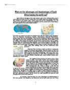
What are the advantages and disadvantages of south africa hosting the world cup 2010?
What are the advantages and disadvantages of South Africa hosting the world cup? South Africa is situated in the most southern part of the continent Africa, and is now hosting the world cup 2010. South Africa has hosted events any football events like this, however it has hosted rugby, cricket, grand prix and the confederations cup. The world cup has affected the economy, the population and the environment of South Africa, the main impact for the country itself is tourism. The world cup matches are held in ten stadiums they will seat 570000 people altogether. They are Polokwane, Rustenburg, Pretoria, Johannesburg, Nelspruit, Bloemfontein, Durban, Cape Town and Port Elizabeth. Five of the ten hosting the matches have already been built, but have been upgraded; the other five are newly built. All the stadiums cost £1.9 billion, which people may arguably say that that it could have been used on helping the population and treating the large population of south Africa that have HIV/AIDS. The changes made to accommodate the stadiums were, all the building surrounding the stadium were knocked down and people in their houses in Durban were given one week notice, along with buildings trees and the environment were destroyed. Whenever there has been a world cup held in a country, the majority of outcomes were positive. Germany world cup 2006 'The world Cup had a very positive effect

Does Halstead Need a Bypass
Halstead is a small market town in South East England, North Essex, and within 15 miles west of Colchester. Halstead is next to the River Colne, and is situated in the Colne Valley. Halstead has a population of 10 000 and is also the only settlement of its size in the Essex region without a bypass. Halstead was also a weaving town (where sheep's wool is made into clothe). Halstead is central to several big towns, such as Colchester, Braintree and Haverhill. Everyday traffic from all these towns has to pass through Halstead high street in order to commute, this usually results in Halstead becoming greatly congested on a regular basis, increasing air and noise pollution, and therefore Halstead central could hugely benefit from a bypass. A bypass is a route, which is built to avoid or 'bypass' congestion in a built up town or village, this lets traffic flow without interferences from local traffic, this improves congestion and road safety. There are many reasons for and against the construction of a bypass. Advantages: * Less congestion in town. * Less pollution in town central. * Lorries would no longer have to drive through the town. * Both noise and air pollution would decrease in town. * Local builders would hugely benefit, from work needed. * It will be quicker for people to travelling to work. Disadvantages: * Expensive, local tax payers of Halstead would

Sea Defence. Which is better: hard or soft engineering?
Which is better: hard or soft engineering? Hard engineering options tend to be expensive, short-term options. They may also have a high impact on the landscape or environment and be unsustainable. Hard engineering is the controlled disruption of natural processes by using man-made structures. An example of hard engineering is a sea wall, these walls are built on the edge of a coastline and made to protect the base of cliffs and also to limit the amount of coastal erosion on a cliff-face were land is being absorbed by the sea. These walls could also prevent coastal flooding. This type of hard engineering is good as it has many aspects and is effective. Disadvantages of creating a sea wall are that it is very expensive to build; the curves in the sea wall reflect the wave's energy back to into the sea, therefore the waves remain powerful. Another disadvantage is that the walls erode after time and the cost of maintenance is high. Another example of hard engineering is groyne, a groyne is a wooden barrier built at a right angle to the beach. Groynes are built to prevent the movement of beach material along the coast by long shore drift. This allows the build-up of a beach; beaches are a natural defence against erosion and also an attraction for tourists. Disadvantages of building a groyne are that it can be seen as unattractive and is also costly to build and maintain. A
Mount Sakurajima volcano report.
By Joseph Hemingway Location: Kyushu, Japan Height: 3,665ft Type: Stratovolcano - also called a composite volcano, is a tall, conical volcano composed of many layers of hardened lava, tephra, and volcanic ash. Last Eruption: 2007 914 * The 1914 eruption has been the most powerful in the Japanese twentieth century. * During the eruption lava flows filled in the narrow strait between the island and the mainland, converting it into a peninsula. * Before 1914, the volcano had been dormant for over a century. * The eruption began on 11 January 1914. * Almost all residents had left the island in the previous days, in response to several large earthquakes which warned them that an eruption was imminent. * Initially, the eruption had been very explosive, generating eruption columns and pyroclastic flows, but after a very large earthquake on 13 January 1914 which killed 35 people, it became effusive, generating a large lava flow. * Lava flows are rare in Japan-the high but the lava flows at Sakurajima continued for months. * The island grew, engulfing several smaller islands nearby, and eventually becoming connected to the mainland by a narrow isthmus. Recent Activity * The volcano resumed activity in 1955, and has been erupting almost constantly ever since. * Thousands of small explosions occur each year, throwing ash to heights of up to a few kilometers above the