Coasts and their management
Coasts and their Management Factors Affecting The Shoreline Environment The coast is a narrow zone that is especially active in the shaping of landforms. In the coastal zone the sea, land and air all meet together and interact to shape the landforms, which are in turn heavily influenced by human activity also. The shoreline (Küste) is the actual boundary (Grenze) of the land and sea. However, when we study coasts, we usually look a little more widely than the shoreline. Coastal terrains extend inland as far as the seawater, salt spray or wind-blown sand extends. They extend seawards to the depth of wave base, which means the depth to which waves can more sediment on the sea bed. It follows from this that the width of a coastal terrain in one area may be very different from its width somewhere else. The coastal terrain may be only a few tens of metres wide on steep, rocky coasts, but it could be tens or hundreds of kilometres wide where estuaries move sea water far inland or where there are wide shallow continental shelves. On the high energy coastlines of southern Australia, the wave base may be 20 metres below sea level, but on the low energy coastlines common in Western Europe, the wave base may be only a few metres below sea level. With the exception of some glacial processes, all the processes that form landforms anywhere in the world operate on coastal terrains. In
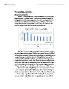
Population Density Comparism
Question for homework. Write an analysis of population density in one state of India. Account for patterns and areas of high/low density. Discuss urban/rural population, people per household and BR/DR/FR/IMR etc. Ans: In this case study I will be looking at one state , that is Punjab, and compare the differences of the population density between two districts, one rural and one urban, within that state, I will do this by looking at the birth rate, death rate fertility rate and infant mortality rate etc. And examining the fact and analysing them which led to the differences. In Jalandhar, the rural district, we see that the population is 1,962,700. In Amritsar, the urban district, the population is 3,096,077. The population is much larger in Amritsar, and we can say that Amritsar is a more urbanised area in Punjab. This is because the government have spent much money to develop the area as it's a major city of tourism due to the location of the golden temple. This has also attracted both tourist and many people from rural areas. So the increase in population adds to the increase of population density in that area. In Jalandhar we see that as it's a rural district the population stays low therefore this plays one major role in leading to the low population density. Another point that I feel is correlated is that the people per household is proportionate to the number of
Shanty Case Study
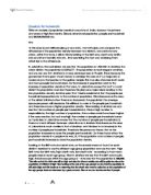
Introduction Many of the world's urban cities today are growing rapidly in population size. Most of the time, there are not enough shelters for all of the people. These homeless people are forced to settle on the outskirts of the city in shanty settlements. Shanties are self-made houses constructed with scraps of materials, such as sheets of plastic and corrugated metal. Shanties, or slums, are a problem because they have poor sanitation, lack of sewage systems, no electricity and no access to clean water. Squatters, people who live in shanties, tend to be rural-urban migrants who could not find work when they came to the city. Shanty settlements are commonly found in Less Economically Developed Countries, but they can also be found in developed countries even though it is illegal to build shanties on land the squatters do not own nor have the permission to live on. The biggest city in Kenya, Nairobi, is an example where shanty settlements are found amongst a rapidly developing center. The populations of country did not seem to relate enough, Kenya 36 million, Nairobi just 2-3 million, so I left it out. Introductory Map- Map One This map shows the location of Nairobi, Kenya. Bibliography http://ec.europa.eu/development/body/publications/courier/courier185/en/en_066.pdf http://www.irinnews.org/report.aspx?reportid=30542

Raconte-moi New York
" Raconte-moi New York " L'éternelle, la perpétuelle, l'illimité cité, n'a pour borne et limite que l'infinité. Le ciel à l'horizon nous est caché par les façades des grattes-ciels, qui comme des falaises, bordent des lignes harmonieuses se prolongent de manière continuée. Ce n'est qu'après avoir véritablement dressé la tête, qu'il se dévoile là, le gardien de cette contrée. New York ne se trouve jamais dans l'état de sommeil, car de nuit, elle s'illumine comme si elle s'était converti, déguisé, mué ou métamorphosé en un miroir, qui reflete des milliers d'étoiles d'un ciel Perseid. Manhattan est renommé pour ces nombreuse fantaisies, dont Central park, l'amas formant un tapis de verdure dans lequel l'on s'y délassé de jours, et s'y sens menassé de nuit. C'est en déambulant que l'on n'y découvre ses clichés les plus surprenants, comme l'obstination pour la couleur jaune des taxis sur la route, et la police ayant pour moyen de locomotion des chevaux. Mais encore, de nombreux immeubles étonnants, comme " the flat iron " qui donne l'impression d'avoir été aplatie avant d'être dressé. En ce même lieu l'on se trouve confronté à telement de difference, entre les gens, leurs races et leurs richesses ; et entre les divers environnements: mêlé et emprisonné dans le brouillard des pots d'échappements, ou délivré au bord de l'Océan
Geography FiledWork: Study of CBD
Geography Field Work A study of the CBD of Hannover Isaure de Zélicourt 2L Candidate number: School code: Table of Contents AIM AND HYPOTHESES 4 Aim 4 Hypotheses 4 LOCATION 5 AREA OF HANNOVER USED FOR THE STUDY 6 THEORETICAL BACKGROUND 7 EXPLANATION OF HYPOTHESES AND METHODOLOGY 9 ASSUMPTIONS 10 DATA PRESENTATION AND ANALYSIS 12 Hypothesis I - The height of buildings 12 Hypothesis II - The environmental quality 13 DESIGN OF A MODEL FOR HANNOVER 15 CONCLUSION AND EVALUATION 16 APPENDICES 17 Appendix A 17 Appendix B 18 Appendix C 19 BIBLIOGRAPHY 20 AIM AND HYPOTHESES Aim ) To investigate the CBD of Hannover and determine whether the CBD complies with the accepted principles. Hypotheses ) The further we walk from the CBD, the lower the building will be. 2) The further we walk from the CBD, the more the environmental quality will decrease. LOCATION AREA OF HANNOVER USED FOR THE STUDY Our study was conducted, in the center of Hannover, capital city of the state of Lower- Saxony, in Northern Germany. Hannover is a modern city as well as state capital with a very well developed public transportation system. We investigated an area of about 4km2 around the departure point, Kröpcke, the peak land value intersection marked as START on figure 3. The routes followed by the groups in the area that we believe to be the CBD of Hannover are indicated with

Statistical Research Question: Does international aid cause more problems than it solves?
Research Assignment Research Question: Does international aid cause more problems than it solves? Hypothesis: The countries that receive international aid have seen an increase in their GDP over the last 20 years International aid is described as 'a voluntary transfer of resources from one country to another, given at least partly with the objective of benefiting the recipient country'1 Aid divides it self into Official aid and Voluntary aid, Official aid is a paid aid, by donor countries, which is given to the government of the recipient country so that they can distribute it. So the Official aid has Multilateral and Bilateral aid, The Multilateral aid, id when richer countries give money international organizations but this is made by the indirectly part, so the money is given to the World Bank or organizations like that. While the Bilateral aid, is like I said before for the official aid, government to government, so it is more directly than the other type of aid. Voluntary aid is when it is given by independent organizations; these organizations raise the money and donate it to the private organizations. Some countries need aid, either because natural hazards, or wars also because people are poor and they need the money. So there are lots of countries that are in debt, but maybe the country will start taking the money and become dependant of it, like the people might

Describe and explain why many LEDCs struggle to increase their Balance of Trade.
WITH REFERENCE TO EXAMPLES, FACTS AND FIGURES, DESCRIBE AND EXPLAIN THE REASONS WHY MANY LEDCS STRUGGLE TO INCREASE THEIR BALANCE OF TRADE. (10 MARKS) The balance of trade is the difference between a country's imports and exports. But around the world there is still a wide imbalance of trade between the LEDCs and MEDCs. This trade gap between LEDCs and MEDCs seems to widen over the years as more and more MEDCs are able to have a trade surplus whereas LEDCs have a trade deficit which might result in making them even poorer or fall in debt. Although 82 per cent of the world's population lived in LEDCs in 2000, but only contribute 24 percent to the world's trend. So why are LEDCs not able or struggle to increase their balance of trade. The gap between LEDCs and MEDCs exists due to the production of primary goods, such as food, in LEDCs that sell their products to MEDCs at low prices, whereas MEDCs supply secondary and sometimes even tertiary products that can be sold at a much higher price. Although the price of the primary goods increased they did not increased as much as the secondary goods which mean LEDCs are not able to gain enough money to gain a trade surplus. A reason for the struggle is that LEDCs are not able to increase their selling price as there are many different LEDCs that can provide the same product and do not raise the price. This results obviously that the

Urbanization and Settlement
Problems and Consequences of Urbanization in the Contemporary World (a) The main change in the location of the worlds top 20 most populous cities between the 50 years (from 1950-2000) is the change in countries which these cities are located in. In the year 1950 most cities (65%--13 out of 20 countries) were located in economically more developed countries (such as USA, Mexico, European nations, and Japan). However in the year 2000 the majority of the cities (80%--16 out of 2o countries) were located in economically less developed countries and NICs (such as Brazil, Argentina, India, China, Philippines, and Indonesia). Countries such as Argentina, Philippines, Indonesia, Thailand, Pakistan, Egypt which were not one of the top most populous cities in 1950 but are predicted to be in the year 2000 are also ELDCs which again fit into the trend that the top 20 cities that are the most populous are shifting from EMDCs to ELDCs. This trend is also strengthen by the fact that in 1950, there were 7 out of 20 cities in Europe however the prediction for the year 2000 did not include any of the previous 7 cities within the ranking. Thus we can again conclude that the most populous cities in 2000 have shifted to cities located in ELDCs. However there are cities that were located in both rankings. Those cities are located in Japan, USA, Mexico, Brazil, China, and India. These are
Markets and Resources
Economists tend to take the view that markets and price mechanisms can more than cope with concerns about resource depletion. Discuss how far you think that they are right. 2006 B With an ever increasing population, concerns about whether or not the world will have enough resources to sustain itself in the future. Many academics, like Simon and Lomborg, often labeled 'technocentric cornucopians' have faith that the markets can ensure an almost infinite supply of resources and are optimistic about the future. To find out what extend the economists are right we need to first look at what a resource is and how markets can influence their supply. A resource is anything that is valuable to and can be used by society. They vary spatially and temporally and therefore come and go as society changes its needs. In the past whole civilizations were named after the resources that sustained them, such as the Stone Age, when flint was valuable to humankind. Nowadays, flint is not considered as a resource. Though the notion of what constitutes a resource also varies spatially, globalization has meant that most of us have some shared idea of what resources are. Currently, depletable rescources include non renewable sources such as fossil fuels and minerals, and critical renewable such as fish, forests and water in aquifers. Economists believe that as proven reserves become more scarce,
The Effect of Changing Distance From Toronto's Central Business District on Parking Prices.
The Effect of Changing Distance From Toronto's Central Business District on Parking Prices Aakash Dheer IB HL Geography Extended Essay Mr. Derek Poon, Advisor 3766 Words Introduction Toronto, Ontario, Canada is one of the most culturally diverse metropolises in the world, with a population of over 4 million people, and a downtown area wielding much of Canada's financial, political, and educational power (United Nations). With many attractive factors, such as business and employment opportunities, entertainment and shopping districts, and the availability of transportation in such a small area, downtown Toronto is quickly becoming very densely populated, with a population of 670,000 people in an area of under 100 square kilometers (Statistics Canada). This population density of over 7000 people per square kilometer will in turn affect demand for housing, services, and parking (Statistics Canada). A fundamental concept of economics is that as demand for a good or service increases, the price of the good or service will increase as well (Parkin). Therefore, in an area with more people living in it, the demand for parking will be higher than a less densely populated area. As a result, the most densely populated area of the city will be the most expensive. In Toronto, this location is the downtown Central Business District (CBD) area, meaning the highest prices for parking