The Amazon River: Case Study
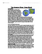
The Amazon River: Case Study Introduction The Amazon River in northern South America, largely in Brazil, ranked as the largest in the world in terms of watershed area, number of tributaries, and volume of water discharged. Measuring about 6275 km (about 3900 miles) from source to mouth, it is second in length only to the Nile among the rivers of the world. With its hundreds of tributaries, the Amazon drains a territory of more than 6 million sq km, roughly half of which is in Brazil; the rest is in Peru, Ecuador, Bolivia, and Venezuela. It is estimated that the Amazon discharges between 34 million and 121 million litres of water per second and deposits a daily average of 3 million tons of sediment near its mouth. The annual outflow from the river accounts for one-fifth of all the fresh water that drains into the oceans of the world. The outpouring of water and sediment is so vast that the salt content and colour of the Atlantic Ocean are altered for a distance of about 320km from the mouth of the river. Course and Physical Environment The major headstreams of the Amazon are the Ucayali and Marañón rivers, both of which rise in the permanent snows and glaciers of the high Andes Mountains and follow parallel courses north before joining near Nauta, Peru. From this confluence the main trunk of the Amazon flows in a generally eastern direction to the Atlantic Ocean. The
Reort on the Colorado River
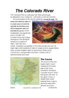
The Colorado River The Colorado River is a principal river that runs through southwestern USA. It flows for 1,450 miles (2,330 km) from the Rocky Mountains to the Gulf of California, running through 7 US states and 2 Mexican states. It is a main source of water for agricultural and urban areas and an important source of hydroelectric power. As the Southwest's only significant source of water, the Colorado River was heavily developed in the twentieth century by a system of dams, reservoirs and canals. It supplies a population of 40 million people and over 29 major dams and hundreds of miles of canals serve to supply thirsty cities, provide irrigation water to around four million acres (16,000 km2), and generate more than 12 billion KWh of hydroelectricity each year. The Course The source of the river begins high in a wet meadow at la Poudre pass in the rocky mountains of western Colorado around 10’000 feet above sea level. In the upper course, it initially flows south towards Mexico and is joined by many other streams and rivers before Colorado River, southwestern USA it enters the state of Utah. Here, the river starts to widen and meander which the Colorado is famous for doing. Meanders are a series of bends in a river which are formed when the moving water in a river erodes the outer banks and widens its valley trying to find the

Geography Field Study River Investigation Coursework
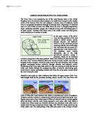
Intro Aims * To investigate what patterns the river Allt Doire Nan Eun shows for wet water depth, water velocity and pH in its three courses. * To investigate whether the river shows textbook characteristics for erosion and deposition in a river channel. * To investigate how rock roundness and moss coverage changes downstream and at different points across a channel. Location During the course of this geography field trip my group set out to investigate the aims stated above. To do this we travelled to Scotland. Once there we stayed at the Kindrogan Field Centre in Enochdhu, Blairgowrie, Perthshire near Pitlochry. Why was this Site Chosen? We studied the river Allt Doire Nan Eun firstly because of the fact that each of its three courses were fairly close to each other due to the relative shortness (meaning that we could travel from one to the next quickly and therefore collect results from each of the three sites- upper, middle and lower course- within a day) and secondly because it was conveniently within easy walking distance from the field centre. Were there any Signs of Human Impact? As can be seen in the two pictures above, some parts of the river, especially in the upper course, are very close to the road (within 10 meters at some points); this meant that the natural formation of the land surrounding the river had been altered, which could have been a cause
River Tees Drainage Baisin
River Tees Drainage Baisin The river Tees flows from the Pennines in Cumbria, northwest England, to the North Sea via Tees Bay. Its length is 130 km / 80 miles. Its port, Teesport, handles in excess of 42 million tonnes of water per year. Its main tributaries are the Lune, Balder, and Greta. There are many factors affecting the drainage baiins of the River Tees, many of these are human factors. Water Barrage and Watersports: Much of the water nearing the sea is polluted with industrial waste, sewage, and chemicals. The Tees Barrage, which opened in 1995, enables a 16 km / 10 mile stretch of the river to provide clean, non-tidal water. The barrage was built to improve the river's watersports facilities by stabilising a stretch of the river which was previously tidal. Four flood gates are operated by hydraulic pistons making sure the river upstream stays at a constant level. Forestry: Much of the Tees Forest has been felled to make room for the built up areas along the river. This decreases the amount of interseption taking place and unnatural concrete surface speed up the flow of runoff into the river. The areas of forest left at river side intersept rain and slow it down, with some also entering the biomass store when the okats absorb the water. Water Treatment: Northumbrian Water operates the Tees raw water system to supply major industrial users with large amounts of

River Mississippi
RIVER MISSISSIPPI Hydrosphere A Case Study of * River management * People interfering in the hydrosphere * A flood management scheme River Basin / Catchment area The source of the river is the eastern side of the Rocky Mountains and the Appalachian Mountains to the north. There are many hundreds of tributaries including the Red River, Missouri river and the river Ohio. The mountains form the river's watershed. From Minneapolis the river flows South-East into Iowa where it flows south as far as Davenport. At Davenport it is joined by more small tributaries. From Davenport it meanders South to St. Louis, where it is joined by the Missouri. It then flows South-East, to be joined by the Ohio. It then flows 400 km before being met by the Arkansas river. It then flows South through Louisiana, to the Gulf of Mexico, where it splits into the many distributaries of its delta. How is the Mississippi controlled ? How & why used ? Benefits Problems Levees Mounds of earth are built parallel to the river, along its banks. These contain the rising river in flood times and protect buildings along the valley on the flood plain behind. * Known & successful technology which follows nature (rivers deposit silt to build natural levees anyway) * Protect settlements * Allow land close to the river to be used for economic gain * Concrete levees are a barrier to the
Landforms located along the River Tees, County Durham
Landforms located along the River Tees, County Durham The River Tees is not necessarily one of the most famous rivers in the United Kingdom, but in its relatively short passage to its mouth from its source in the marshy moors of the Pennine Hills, the river produces a diverse array of landforms, which vary as it progresses downstream through its drainage basin. Beginning in a saturated moor as a mere trickle of water over 600m above sea level, it emerges progressively larger, producing waterfalls, gorges and V-shaped valleys with interlocking spurs in its upper course, meanders and oxbow lakes in the middle course and flood plains, levees and deltas as it reaches its mouth. In the upper course of the River Tees, the steep gradient of the land results in vertical erosion, mainly through abrasion and hydraulic action to be the dominant process occurring with the river at this stage. The Tees starts from its source in a saturated moor in the Pennine Hills. The abundant water trickles downwards, due to the high gravitational potential energy it possesses, which can be converted to kinetic energy due to the steep gradient. These mere trickles of water develop into the River Tees. Various tributaries add to the volume of water and the river uses its abundant kinetic energy to vertically erode away at the bed and banks, with its steep gradient encourages erosion vertically

How a river changes from source to mouth
How a River changes from source to mouth The Long Profile The long river profile is the changes in gradient at different stages in a river's flow. In the Upper Course the flow is fast and load and water volume are slow. In the Middle Course the river starts to slow and volume increases when tributaries join the river. The river erodes at this stage and the load increases. In the Lower Course, the river slows down dramatically due the gradient being almost flat. The river deposits its load due to the lack of power and speed. The volume is the largest on the river's course. This part of a river is liable to flood. Upper course The upper course is usually found in the mountains and hills where the river rises from its source. Waterfalls and rapids are also sometimes found in this course. Water falls are caused when a river runs over alternating layers of hard and soft rock. The river in the upper course is usually fast flowing. There are lots of obstacles, stones and boulders for the water to flow over. As the river moves all the way through the upper course it cuts downwards. The steepness here is steep and the river channel is narrow. Vertical erosion in this highland part of the river creates steep sided V-shaped valleys and interlocking spurs. These are caused as the river erodes the landscape in the upper course, it winds and bends avoiding areas of hard rock.

River Processes Revision Notes and Questions.
River processes (Page 6-7) Erosion can affect the length, Depth and Width of a river Vertical erosion deepens river channels. It happens in the upper stages of a river. Lateral erosion makes the river wide. This happens in the middle and lower stages of a river. Headward erosion makes the river longer. It happens near a rivers source as throughflow and surface runoff causes erosion at the point the water enters the river channel. . Hydraulic Action – the pressure of the water breaks rock particles away from the bed and the banks. Its strongest in rapids and waterfalls and during floods. 2. Abrasion (Corrasion) – eroded pieces of rock in the water scrape and rub against banks, removing material. Most erosion occurs this way. 3. Attrition – eroded rock smash into each other and break into smaller fragments. Their edges get rounded off as they rub together. Attrition doesn’t erode the bed and banks, just makes rock in river smaller and rounded. 4. Cavitation – air bubbles in turbulent stretches of water implode causing shockwaves that break pieces off the banks and bed 5. Corrosion (solution) - the dissolving of rock by chemical proces. Carbon dioxide dissolves in water to form a weak acid, which reacts with rock like limestone and chalk, breaking them down. Transportation Deposition: process of dropping ERODED material Occours when the river loses
How A River Changes As It goes Downstream.
How A River Changes As It goes Downstream A rivers course starts in the mountains or relatively highland area and ends up meeting the sea. As a river travels downstream it changes in many ways. Different features are made and different processes take place. These things take place in different stages of the river. There are 3 stages in total. The upper course, the middle course and the lower course. In the upper course, the start of the river is called the source. It is usually a small lake or spring. In the mountains there are also small tributaries that feed into the main river at the confluence. In this particular part of the course the width is small and the depth is very shallow. The channel gradient is very steep allowing the water to just trickle down the hill because it hasn't got enough water to flow. The velocity is also very minor. In this part of the course, erosion is the dominant process. The river may erode creating different features by any of the four erosion processes. They are hydraulic power, which is the force of the water against the riverbed and bank removing material. This is particularly important when the river is in flood. Corrasion is when the particles of sand, silt, pebbles or boulders carried by the river rub against the bed and banks, wearing them away. The third is corrosion, which is when rocks dissolve in the slightly acidic water. The

Credit River Abiotic Feature Study
IB ENVIRONMENTAL SYSTEMS Lab 7: Abiotic Features in the Credit River Planning A Introduction The Credit River is an open freshwater system that flows through a predominantly agricultural sector of southern Ontario. The river is approximately 1,500km long and drains into Lake Ontario at Port Credit. Due to urbanization, lower sections of the river have experienced reduced water quality but still remains to attract a variety of species. Research Question What are the physical and biological components that influence biotic life with regard to abundance and Diversity in the freshwater habitat of the Credit River?i Hypothesis Relationships between abiotic components will be investigated in this fresh water ecosystem. The main abiotic characteristics in the Credit River that will be explored include; oxygen reduction potential, depth and temperature. Furthermore, abiotic limiting factors such as seasonal differences will be evaluated and discussed. As a result, I hypothesize that quadrants with high oxygen reduction potentials will be colder. Another abiotic factor that will influence the temperature of the Credit River is the average depth. I hypothesize that quadrants with a greater depth will have a lower average temperature than those with a more shallow depth. Lastly, I predict that quadrants with higher velocities will equate to an increased temperature in the


