Stoke Bruerne is a small village near towcestor off of the A5 in between Birmingham and London on the Grand Union Canal.
Stoke Bruerne. Stoke Bruerne is a small village near towcestor off of the A5 in between Birmingham and London on the Grand Union Canal. There was various land owners before 1805, one of them was the 'Saxon lord' swain son of Azor, son of lefs, Lord of Stoke, he in 1086 herd 21 houses with families of 'villains and borders' the total value of the houses was 10 shillings a year. After swain the 'Saxon lord' died with no heirs a Norman Noble took the land , it then passed from one family to another, it acquired the name Bruerne from sir William de Bruerne, who was a friend of both king Richard the 'lion heart' and his brother King John. De Bruerne help the manor of stoke and also sitlehanger (shutlanger) and Aldrintone (Alderton) from William de Warenn Earl of Surrey, He was also a substantial Landowner. At the beginning of the 13th century Sir William was given the manor of Stoke Bruerne, and in 1217 he appointed the first Rector of Stoke Bruerne, named Richard de Rolf. In Stoke Bruerne the population increased from 609 people in 1801 to 823 people in 1971. Pre 1805 Stoke Bruerne was a small simple Hamlet, it had a figure of either setting, it had a church surrounded by thatched cottages, and then there was the farms in separate areas. Most of the people who lived there were farmhands and had very low wages, they also did not have much if any knowledge of other

Compare two seaside towns that I visited in March 2003. The two towns, Frinton-on-Sea and Walton-on the-Naze can be located side by side on the east coast of Britain.
Introduction...........................................2 Aims and Methodology.........................4 Data Presentation and Interpretation.................8 Conclusion.......................................... 18 Evaluation.......................................... 19 Seaside resorts are towns that have been recognized along the coastlines. Seaside resorts offer a wide range of entertainment facilities in addition to their wide sandy beaches and sunny weather. Although many people live in these areas, they attract tourists from nearby regions as well. There are several popular seaside resorts in Britain, many of which are located close to large cities. Some of these resorts are Blackpool, Brighton and Great Yarmouth. There is a large variety of leisure services provided by these resorts. The main reason however, continues to be the natural features of the coast. Therefore the main activities expected in such areas include sun bathing, swimming, surfing, boating, rock climbing and quite a few other beach sports and activities. Human additions have also been made to these existing facilities in order to enhance them. So, we could expect to find people occupied in activities like shopping and entertainment. While each seaside resort is unique, most have a land use structure that is similar for all seaside resorts. Leisure and housing facilities such as promenades,

See how the town of Blaina in South Wales has responded to change in its economic geography.
In this coursework I aim to see how the town of Blaina in South Wales has responded to change in its economic geography. In order for me to do this I have used a variety of methods such as questionnaires, surveys, maps and simple observations. Through my research I have discovered how old mining villages such as Blaina and six bells in the Ebbw Fach Valley have been affected through coal mine closures. Job losses where on a mass scale and affected small communities, this also affected their quality of life. My Hypothesis ) Most of the housing was developed in the 19th century This was during the period of rapid economic growth. At this time this area of Great Britain was one of the main industrial regions, as jobs became available people moved to the area so houses where built to accommodate them. This affected an increased economy all around the growing communities 2) The quality of housing declined since the loss of the coal industry in these particular towns. The closure of local coal mines affected the de-industrialization of the area. The doom and gloom spiral suggests that poor quality housing is a result from the decline of industry and economic structure of a town. Although many houses have shown signs of decay, there have been recent attempts to improve the housing stock, this includes things such as: Windows Roof tiles Brickwork Doors Toilets

Llandudno urban study
GCSE Coursework Tseden Taddese Candidate number - 0195 Introduction Aim: . To study the land use pattern of Llandudno 2. To establish Llandudno's sphere of influence 3. To see the size of the CBD in Llandudno 4. To study Llandudno as a retail and tourism centre Hypotheses The hypotheses that I am going to use in this project are the following: . Llandudno has sphere of influence and this serves the hole of Conwy County; 2. The CBD can be found by the number of pedestrians; 3. Mostyn Champneys' retail park will have an impact on the shoppers and the CBD; 4. The main land use on Mostyn Street is shops Background information Until 1843 Llandudno was just a small fishing village at the foot of the Great Orme. A man called M.E.Mostyn M.P realised that an opportunity was available to turn Llandudno into seaside resort. This area had everything he needed for example low rainfall, high sunshine and ancient buildings. In 1843 he bought 955 acres Llandudno and about half of it was on the sea front. He became the owner and development controller for most of the towns. In 1854 there were 21 commissioners which set strict rules on what people can and cannot built. Saps, hydros and hotels were built on the land. In 1891 Llandudno boomed as tourist resort after the railway along the N.Wales coast was completed. This made the town to attract people from Liverpool,

What effects people's shopping habits in my local area?
What effects people's shopping habits in my local area? Contents: Contents page...........................................page one. Introduction.............................................page two. Objective one...........................................page three. Objective two...........................................page five. Objective three..........................................page seven. Objective four..........................................page thirteen. Conclusion..............................................page fifteen. Evaluation...............................................page sixteen. Photos...................................................At the back. What affects shopping patterns in my local area of Denton? Introduction I have decided to look in depth into the affects of shopping patterns in my local area; To simplify the task, I have decided to split up the coursework into four easy to handle objectives; * How the types of shops and services available affects the shopping patterns of people, * How the hierarchy of settlements affects shopping patterns, * Where people come from to shop in my study area and what affects their decision, * How has the opening of new developments, and proposed developments, affected people's shopping habits in the local area? The area to which I am local is Denton and therefore I will be looking
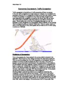
To what extent is traffic congestion happening in Hexham town centre and what should be done to reduce the problem?
To what extent is traffic congestion happening in Hexham town centre and what should be done to reduce the problem? INTRODUCTION For my course work i will look to explore the extent of the problem of congestion in Hexham. Also i will look to investigate what should be done to help reduce this problem. The things in which i will be looking into to examine the problems of congestion will be things such as counting the amount of cars in carparks and counting the amount of traffic on the roads for 10 minutes. i will also do a questionare and mapping traffic hazards. here are four possible solutions which i feel will help reduce the amount of traffic congestion in hexham : pedestrianise the market place, introduce a one way system through the town centre, create new parking areas nearer the town centre and introduce a park and ride scheme at the tyne green which will allow people to park there cars at the tyne green and then a bus will transport them to the town centre. Finally i propose that we leave things as they are. It is important to reduce congestion so that we can reduce the amount of pollution which will create an enviromental hazard which will lead to health problems. Also it will reduce the amount of traffic related road accidents and it will make the roads safer. Also i will be looking into the background information of heham. Hexham has old narrow roads, There

An investigation to find the centre of Huntingdon's CBD.
By Eliana Tacconi Contents * Introduction and Aims 3 History Land Use Map Aims Expectations Urban Structure Models * Data Collection 9 Primary Data Secondary Data Site Map Problems and Limitations Summary Tables Original Data * Data Presentation 16 Justification of methods Annotated photographs showing land use and characteristics of a CBD Maps showing population flow, building age, environmental quality and survey results * Analysis and Conclusions 29 Analysis Conclusions Evaluations * Introduction and Aims .1 A map of the United Kingdom showing the location of Huntingdon Huntingdon is a town located in Cambridgeshire, East Anglia and the population of Huntingdon is estimated at 20,000. Huntingdon has grown and changed a great deal from how it was originally. It has grown out from the oldest part which I believe is Market Square. Huntingdon is mainly shops and offices in the CBD but there is a little Housing. Further out there is a lot more housing both expensive and cheaper and many industrial parks. The town is still growing as more and more housing is being built due to the easy one hour commute to London on the train and the good transport links North, South, East and West because of the A14 and A1. Overall the amount of restaurants and pubs has increased in the last 15 years as has the amount of offices and the amount of

Geography Pedestrian Survey
Data collection This chapter is about how I collected the data for my surveys, and why I collected it in the methods I used. The Pedestrian Survey For this survey, the whole class worked as a group. We started by being given a grided map of Halifax's Central Business District and a small area surrounding it. Our teacher kept a copy of this as the master map. Each square on the map could be identified like the one below. This made identification of points easy. On this map there were (number) points marked by dots (see above) in the Central Business District and beyond. These were then grouped together into groups of approximately seven. The class was then split into pairs, and each pair was then allocated one of the groups of dots. The reason for working in pairs is so that one person could time and one could count the people passing. It was also for safety reasons. Before we started the count, we worked out some rules or guidelines for the whole class to follow. These were to * To count all people that passed, including babies in prams. * To not count pets/ animals * To count everyone on ONE side of the road only, except in precinct locations where everyone in the precinct was counted. A time limit of 5 minutes per point was decided. Each pair then went to their separate points to start counting/ timing. My pair had 6 points to count, so for 3 points person A timed

Geography Coursework
Geography Coursework Christopher-John Hammond Contents page Collection and Selection of Primary and Secondary Data Page 1 Introduction Page 2 House Pricing Page 3-6 Location, Maps and Photos Page 7 Hypothesis Page 8-9 Key Geographical Terms Page 10 Geographical Theory - Shopping Hierarchy Page 11 Geographical Theory - The Burgess Model Page 12-13 Method table Data Presentation Page 14 Hypothesis 1 Page 15 Hitchin Dot and Isoline Map Page 16 Southgate Dot and Isoline Map Page 17 Pedestrian Density Table Page 18 Pedestrian Density Scatter Graph Page 19-20 Spearmans Rank Page 21 Hypothesis 2 Page 22 Hitchin Environmental Quality Table Page 23 Hitchin Environmental Quality Stacked Bar Graph Page 24 Southgate Environmental Quality Table Page 25 Southgate Environmental Quality Stacked Bar Graph Page 26 Hypothesis 3 Page 27 Sphere of Influence Map for Hitchin Page 28 Sphere of Influence Table for Southgate Page 29 Sphere of Influence Graph for Southgate Page 30 Hypothesis 4 Page 31 Land Use Map for Hitchin Page 32 Land Use Map for Southgate Page 33 A Bar Graph to Show Types of Services in Hitchin Page 34 A Bar Graph to Show Types of Services in Southgate Page 35 Questionnaire Tables for Hitchin and Southgate Page 36 Questionnaire Graph for Southgate Page 37 Questionnaire Graph for Southgate Page 38 Questionnaire Graph for

Geography Courswork
Geography Coursework This is the first part of my geography coursework; this coursework will be based upon the Ilford town centre and also an area which I choose. In this coursework I will describe the changes which have occurred in Ilford over the last decade, these changes include: * How the Ilford car park has changed into a multiplex cineworld * How there has been a diverse change in the local community within Ilford * How the shops have affected the local community and their own customers However to illustrate these changes I will be interviewing families in the local area which have been affected by the change, and also local shop areas. I will also be using a questionnaire to find out the views and thoughts of the local community and people who visit Ilford regularly. I will be questioning them about how the change in Ilford has affected them. I will also be comparing Ilford and my local area as it is in the vicinity of Ilford, this will show the differences and similarities between the two local areas. The main aspects which I will be comparing between the two areas are: * Land Use * Roads * Bus Service * Trains * Shops Over the last two decades Ilford has been through rapid changes, including the structure, commercial properties, population and one of the most noticeable changes is the transformation of the Ilford car park to a multiplex cinema. Above is a