Coastal Management
Coastal protection and erosion in Sidmouth. Sidmouth is a thriving seaside town near Exeter in Devon. As it experiences coastal erosion, many different erosion features can be found there. Sidmouth has protected and unprotected areas of coast. The protected are has a number of strategies to try to prevent erosion. The unprotected site experiences much erosion, and the cliffs slump and have other erosion problems. The protected area is directly in front of the town centre, and locals call it Town Beach. The waves at Sidmouth are powerful at times, and if it were not for the coastal defences, much of the town would have been lost to the sea. Town Beach has many coastal protection strategies in place, such as bull-nosed seawall, footpaths, and offshore breakwaters, rip rap and beach nourishment which is bringing sand/shingle from elsewhere to replenish the beach material washed away by the sea. The land behind Town Beach is valuable, as many shops, residential properties and hotels which provide money for the local areas and encourage tourism are found there. It is therefore essential that this land is not lost to the sea. Coastal defences cost a lot of money, and as the town has tried to make the beaches look aesthetically pleasing, it has imported large heavy boulders as opposed to other cheaper materials. However, the coastal defences built to protect Town Beach have
Austraila's Trade and Treaties
AUSTRALIA'S REGOINAL AND GLOBAL MILITARY LINKS Australia has extensive regional and global military ties. These take a number of forms, including treaty agreements, joint military training and the training of overseas military personal. These links may be bilateral, regional or multilateral in nature. Many of these links can be traced back to the various military conflicts in which Australia has been involved since 1899. HISTORICAL ALLIANCES Australia's long standing military ties with the United Kingdom date from our colonial past. The first conflict in which the newly created Australian nation was involved was Boer war of 1899-1902. Australia felt "duty bound" to come to "mother country" aid its conflict with Dutch settler in South Africa. This attitude also explains why Australia went to the aid of the United Kingdom in both world wars. Since World War 2, Australia has developed closer military ties with the United States. This involvement dates from the time when Australia was forced to turn to the United States to help repel the Japanese advance though Southeast Asia and the Pacific during the early 1940's. As part of its involvement in the "Pacific Campaign" the United States established a number of large military bases in the Asia-Pacific region. Following our involvement in the Pacific Campaign the Australian military established close links with the US military.
Explain why, for both physical and human reasons, some coastlines attract more human management than others
A2 Geography Essay Explain why, for both physical and human reasons, some coastlines attract more human management than others. Coastal management involves controlling development and change, and undertaking works in the coastal zone. Good management involves taking into account both physical and environmental considerations, as well as the views of local residents and others involved. There are two different types of coastal engineering, the 'hard' and 'soft' strategies. Hard engineering includes man made defences such as sea walls, a costly wall place on the seaward side away from the base of the cliffs needing an additional advanced line of protection such as rocks on their seaward side. Groynes, timber posts and boards which run out to the sea at right angles to trap sediment drifting along the coast. Gabions, cages enclosing shingle or small blocks of rocks, and revetments, defences that are aligned parallel to the shore including post, pillars or walls of rocks placed on the foreshore. Soft engineering includes planting trees and grasses in and around the beach, encouraging sand nourishment by adding more sand, and then most drastically, a managed retreat which involves moving homes and farmland. Some coastlines that would attract lots of human management are those that are areas of large settlements. When people live in a coastal area they do not want to have to
How Does California Prepare For Earthquakes?
How Does California Prepare For Earthquakes California is located on the San Andres fault which is where the North American (continental plate boundary) and Pacific Plate (oceanic plate boundary) meet. This is a convergent plate boundary where both the North American and Pacific plate are sliding past each other northwards but the Pacific Plate is moving faster than the North American plate. These results in approximately thirty one earthquakes occurring in California each day but the majority of the earthquakes are so small that they are not felt. The high amounts of small earthquakes are building up pressure in the crust so eventually there will be an earthquake of a very high magnitude. This is why California has to prepare for the high magnitude earthquake. All residents in California have or at least should have, an emergency evacuation plan so they know exactly what to do immediately after an earthquake, a First Aid kit it assist in case someone is injured, a stored supply of water where every person in a household can consume a gallon of water per day for three days, and finally, a fire extinguisher if a fire was to take place because of broken gas lines. People in general should think about earthquake insurance and to lower injury risks in the home, and they have to secure their furniture by bolting them to walls and the floor. Earthquake preparedness drills have
Why did Harry Truman die in the Mt St. Helens eruption?
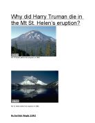
Why did Harry Truman die in the Mt St. Helen’s eruption? Mt St Helens before the eruption in 1980. Mt St. Helens after the eruption in 1980. Why did Harry Truman die in Mt St Helen’s 1980 eruption? Mount St Helens is a volcanic mountain which is found on the west coast of the United States of America. The USA lies in the continent of North America. Mount Saint Helens can be found on the state of Washington and it is approximately 95 miles south of Seattle (Capital city of the State Washington) and 50 miles (80 km) northeast of Portland, Oregon. Mount Saint Helens lies in the mountain range of Cascades which is mainly made up of volcanic mountains such as Mount st Helens due to the fact that the volcano is located in the Cascade Range and the Cascade Volcanic Arc, a segment of the Pacific Ring of Fire that includes over 160 active volcanoes. This volcano is well known for its ash explosions and pyroclastic flows. Fig 1. A Map of the Cascades mountain range that shows the volcanoes and mountain ranges. Fig 2. A Picture of the Cascades mountain range that shows some of the volcanoes located there. Mount St Helens. Mount St Helens is a type of strato-volcano most commonly known as a composite volcano. Composite volcanoes are volcanoes that have steep sides and are made up of alternate layers of ash and lava from previous eruption. Composite volcanoes do not erupt

How has the flora and fauna of the rainforest adapted to their environment?
How has the flora and fauna of the rainforest adapted to their environment? More species of flora and fauna live in rainforests than in any other habitat on earth. Scientists believe that this is because the rainforests are the oldest ecosystems on the planet, with some forests in Asia dating to around 100 million years ago. Also, due to the location of the rainforests, the ice ages did not reach or affect them, but made many other species in other areas extinct. But this large variety of flora and fauna also means there is much competition for survival, and how have the flora and fauna adapted to their environment? Fauna is the term referring to animal life living in a region. In rainforests, there are thought to be about half of the world’s animal species. Over 500 mammals, 175 lizards and over 300 other reptile species, and one third of the world's birds live in Amazonia. It is estimated that about 30 million insect types can be found here. These animals have adapted in many ways to survive in and make good use of its habitat. Flora refers to the plant life living in a region. In rainforests, the variation of the flora is extremely extensive, with about half of the earth’s plant species again living within them. In fact, the rainforest is sometimes called the ‘Lungs of the Earth’ because it is estimated that its plants recycle about 20% of Carbon Dioxide into
Reort on the Colorado River
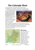
The Colorado River The Colorado River is a principal river that runs through southwestern USA. It flows for 1,450 miles (2,330 km) from the Rocky Mountains to the Gulf of California, running through 7 US states and 2 Mexican states. It is a main source of water for agricultural and urban areas and an important source of hydroelectric power. As the Southwest's only significant source of water, the Colorado River was heavily developed in the twentieth century by a system of dams, reservoirs and canals. It supplies a population of 40 million people and over 29 major dams and hundreds of miles of canals serve to supply thirsty cities, provide irrigation water to around four million acres (16,000 km2), and generate more than 12 billion KWh of hydroelectricity each year. The Course The source of the river begins high in a wet meadow at la Poudre pass in the rocky mountains of western Colorado around 10’000 feet above sea level. In the upper course, it initially flows south towards Mexico and is joined by many other streams and rivers before Colorado River, southwestern USA it enters the state of Utah. Here, the river starts to widen and meander which the Colorado is famous for doing. Meanders are a series of bends in a river which are formed when the moving water in a river erodes the outer banks and widens its valley trying to find the
Eyjafjallajkull - the Icelandic volcano eruption
Eyjafjallajökull Evacuations About 500 farmers and their families from the areas of Fljótshlíð, Eyjafjöll, and Landeyjar were evacuated overnight (including a group of 30 schoolchildren and their 3 teachers from Caistor Grammar School in England), and flights to and from Reykjavík and Keflavík International Airport were postponed, but on the evening of 21 March, domestic and international air traffic was allowed again Inhabitants of the risk zone of Fljótshlíð, Eyjafjöll, and Landeyjar area were allowed to return to their farms and homes after an evening meeting with the Civil Protection Department on 22 March and the evacuation plan was temporarily dismissed. Instead, the police closed the road to Þórsmörk, and the four-wheel-drive trail from Skógar village to the Fimmvörðuháls mountain pass, but these roads and trails were reopened on 29 March, though only for suitable four-wheel drives. When the second fissure appeared, the road was closed again because of the danger of flash floods, which could have developed if the fissure had opened near big ice caps or other snow reservoirs, but the road was again opened at around noon on 1 April. (1,800 °F) up to 150 metres (490 ft) into the air. The lava is alkali olivine basalt and is relatively viscous causing the motion of the lava stream to the west and east of the fissure to be slow. The molten lava has

Fold Mountains case study - Andes
Fold Mountain Case Study – The Andes The Andes Mountains run the length of the West Coast of South America, rising in the North in Colombia and finishing in Chile and Argentina in the South. They are world's longest mountain range running for over 7,000km and covering 6 countries. The mountains have been formed as a result of the convergence of the Nazca plate and the South American plate. The heavier oceanic crust of the Nazca plate is pushed towards the South American plate, and because it is denser is subducted underneath. The South American plate is less dense so sits on top of this subduction zone, but the rocks of the South American plate have been folded upwards and crumpled into Fold Mountains. There are also Volcanoes and earthquakes along this destructive plate boundary - earthquakes caused by stresses building up as the 2 plates try to move past one another, and volcanoes caused by magma working its way up through vents in the Earth's crust. This has created a sequence of volcanoes and Fold Mountains, rising up to 6962m at Aconcagua. The trench (marking the boundary between the Nazca and South American plates) to the West of the Andes Mountains is called the Peru-Chile Trench, and reaches an incredible depth of 8066m under the sea level. These areas are very hard to live in because of the physical geography. The relief is very steep making farming

Geography- Does the UK have any extreme environments?
Geography- Does the UK have any extreme environments? The Lake District National Park is the mountainous region located in the north - west of England, in the county of Cumbria, just south of Scotland. It's the largest National Park in England and Wales. It covers approximately 2,290 km/ 800 square miles. Lake District is a mountainous area which makes population settlement difficult because of its high altitude environment. The floods of November 2009 were consistent with predictions for climate change and around 1,300 homes and businesses were destroyed by the floods. The climate of Lake District is not temperate; the region has very high rainfall between 100mm and 250mm. During the year, the temperature is very windy and the fog is dense, the temperature could go down to -18’c. Furthermore there are factors which suggest that this is an extreme environment, as in some cases there is damage to public access and transport infrastructure by extreme weather events particularly floods of sea level rise damaging public access and buildings. Lower river flows and lake levels will result in pollution and higher water temperatures in summer leading to impacts on vulnerable species, therefore will impact vegetation too. However, there are access to shops, medical help, doctors and schools, internet access, transport and electricity. In the region of Lake District, the