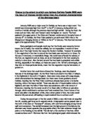
The characteristics of air temperature at a mountain station Grachen, in Wallis and the river flow from a glacierised basin Kanton Wallis in the Swiss Alps
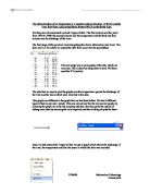
The characteristics of air temperature at a mountain station Grachen, in Wallis and the river flow from a glacierised basin Kanton Wallis in the Swiss Alps For this piece of coursework we had 3 types of data. The first column was the years from 1970 to 1999, the second column was the temperature and the third and final column was the discharge of the river. The first stage of this practical involved getting the above information into Excel. The data was in a file which we copied the data from a put into the spreadsheet. The next stage was to plot graphs of the data which we received. This is done by using chart wizard. We them used the XY (scatter) The data that we used to plot the graphs was the temperature against the discharge of the river and the years which were involved in the data. This graph was different to the graph that we had done before. We had 3 different types of data to put into 1 graph. This was carried out like the any normal graph, by selecting the graph we want and selecting add data, this then gives the option of adding more data by selecting the cells required and then clicking ok puts the three Once we had entered the 3 types of data we got a graph which shows the discharge of the river, the temperature and also the years in which the data was recorded The next stage was to plot just the air temperature against the discharge. So as before the
Geography Coursework: Epping Forest
Abstract This is a study of the changes in river processes along the long profile of a river. To study this we will use a sample river. The river the study will be based on Loughton Brook, which is a river situated in Epping Forest in Essex and is also a tributary of the river Thames. A journey will be made to the river and measurements will be made at three different sites. The measurements that were taken will be studied so conclusions can be made about the changes to characteristics of a river with distance downstream. Aims and Hypotheses The overall aim of this study is to investigate the changes in river characteristics downstream along Loughton Brook. To investigate these changes in more detail a range of hypotheses will be tested. These hypotheses are: . The width of the river channel will increase with distance downstream. I expect to find this because in the long profile of a river channel width increases. This is because there is a greater volume of water at a faster velocity. This causes more hydraulic power erosion in the river channel downstream, which makes the channel wider. 2. The depth of the river channel will increase with distance downstream. I am expecting to find this because as the velocity of the river increase further downstream there will be more hydraulic power erosion which will cause the river to become deeper. 3. The wetted
Microclimates: Detailed Study.
Do Microclimates exist around Dulwich College grounds? Introduction Microclimates are small areas which have a different climate from the surrounding areas. Microclimates can be created by many things. The surface of a place can affect its microclimate. Places with tarmac or concrete type flooring shall be warmer than places with grass ground. Shelters can also be a cause for microclimates to occur. The shelters can block the sun making it cooler or block the wind to make it warmer. The shelters can also give shade which can also make it cooler. The physical features can create microclimates. For example: a place with trees, grass, or lakes will be much cooler and shadier than a place surrounded by buildings. The direction of a place can affect how or cold it may be during the different times of the day. Microclimates are also affected if there is city near by or if you are living in one. The time of day can also be a crucial element to creating a microclimate. The positioning of the sun can also affect if there is or is not a microclimate. Places with small towns and countryside will be much cooler than large cities. This affect is called "Urban Heating Island Effect". Microclimates can exist everywhere if the appropriate conditions occur. There could be a microclimate in the two courtyards in between the senior building, or in the junior school inner
River Landscapes and Processes
River Landscapes and Processes Some important words and definitions: . Fluvial Landscape - a landscape created by rivers and their tributaries. 2. Tributary - a small river or stream which joins to a larger one. 3. River or drainage basin - an area drained by a single river together with all of its tributaries. 4. Confluence - where 2 or more streams, rivers or tributaries join together. 5. Watershed - The boundary line between different river/drainage basins. (Sometimes these are referred to as Catchment areas) 6. Source - The starting point of a river or stream. (watercourse) - This maybe a spring or just an area of boggy/marshy land. 7. Channel - the space between the banks of the watercourse in which the river flows, and may vary form a few meters to hundreds of kilometres. 8. Mouth - the point at which the river enters the sea or a lake. 9. Delta - the mouth of a river that splits into many channels (or distributaries) e.g. The River Mississippi or the River Nile. 0. Long Profile - the cross-section of a rivers course from its source to its mouth. 1. Cross Profile - a section across the valley of the river at any given point. How Do Rivers Shape The Land? There are 4 main processes by which a river can cause erosion (wearing away) and 4 processes by which a river can transport (move) material. * Processes of erosion . Attrition - breaking up of material

River course project.
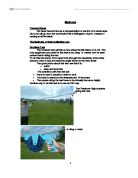
Map of Area List of Apparatus * Chain * Clinometer * Net * Bucket * Tape Measure * Measuring Poles * Flow Metre * Ruler (1 metre) * Dog Biscuits * Stop Watch Aims * To measure the length of the wetted perimeter * To measure of the river * To measure the depth of the river at five different intervals * To study the velocity of the river at five different intervals * To measure the gradient of the river * To study the level of pollution in the river Methods Used Wetted Perimeter Measuring the length of the river 4 sites along Afon Conwy 10m sections. A chain (red) and a tape measure were used to work out the wetted perimeter. The chain from the water surface on one bank was taken to the opposite bank and the length of the chain was measured. Measuring the Wetted Perimeter (above) Width Measuring the Width (below) A tape was used to measure the water surface on one bank to the water surface on the other bank. (Hypothesis 1) Depth The width of the channel was taken and divided into six. The depth was measured at five different intervals using a 1 metre ruler. (Hypothesis 3) Velocity Measuring the Velocity (below) The width of the channel was taken and divided into six. The flow meter was two-thirds of the way down and timed 30 seconds to see how many revolutions the impeller turned in order to work out the velocity of the river using a flow

On Thursday 9th of September 1999, year 9 left for their Geography field trip to Hennock in Devon. Hennock is a small settlement near to a place called Bovey Tracey. A large town within twenty miles is Newton Abbot.
Introduction On Thursday 9th of September 1999, year 9 left for their Geography field trip to Hennock in Devon. Hennock is a small settlement near to a place called Bovey Tracey. A large town within twenty miles is Newton Abbot. We drove in a coach to Hennock, down the A303 past 'Stonehenge', travelled west down towards Exeter, took the M5 south towards Newton Abbot, then took the A38 to Hennock (see figure 1). We stayed in a converted Devon Farm House. The centre is called Longlands Field Study Centre where we spent two days investigating the River Lemon (see plate 1). We returned to school on Sunday 12th September after a lot of hard work and fun. The purpose of the study was to carry out a detailed investigation of the River Lemon, its surrounding area, and the water flow for our Geography Field Project. The River Lemon was chosen because it was short enough to be studied in its entirety (35 miles long) over a weekend. The area contained considerable points of interest, and demonstrated a contrasting location compared to the outskirts of London (see figure 2). The five hypothesis we tested were: * The speed of the water is fastest on the outer bank of a meander. * The deepest part of a meander is on the outside bank. * The fastest flow of water on a straight section is in the middle of the river. * The deepest part of a straight section is in the middle. * The
The Amazon River: Case Study
The Amazon River: Case Study Introduction The Amazon River in northern South America, largely in Brazil, ranked as the largest in the world in terms of watershed area, number of tributaries, and volume of water discharged. Measuring about 6275 km (about 3900 miles) from source to mouth, it is second in length only to the Nile among the rivers of the world. With its hundreds of tributaries, the Amazon drains a territory of more than 6 million sq km, roughly half of which is in Brazil; the rest is in Peru, Ecuador, Bolivia, and Venezuela. It is estimated that the Amazon discharges between 34 million and 121 million litres of water per second and deposits a daily average of 3 million tons of sediment near its mouth. The annual outflow from the river accounts for one-fifth of all the fresh water that drains into the oceans of the world. The outpouring of water and sediment is so vast that the salt content and colour of the Atlantic Ocean are altered for a distance of about 320km from the mouth of the river. Course and Physical Environment The major headstreams of the Amazon are the Ucayali and Marañón rivers, both of which rise in the permanent snows and glaciers of the high Andes Mountains and follow parallel courses north before joining near Nauta, Peru. From this confluence the main trunk of the Amazon flows in a generally eastern direction to the Atlantic Ocean. The

The Drainage Basin - Bangladesh
WATER - HYDROLOGY CASE STUDY RIVERS OF BANGLADESH Meghna, Ganges, Brahmaputra The Drainage Basin Extensive, covering much of Bangladesh, parts of India, Nepal and China. The Himalayas and Tibetan Plateau form the rivers' watershed. The river Brahmaputra detours over a thousand kilometres as the river has not been able to cut a valley through the resistant rock of the Himalayas. The flood plain covers about 50% of Bangladesh's land area. The river erodes material in its upper course in China, India and Nepal, carrying huge amounts of sediment to be deposited as the river slows crossing the floodplain and delta of Bangladesh. The river enters the Bay of Bengal through its distributaries in the delta. How and why does the river flood ? . MONSOON & SNOWMELT : along the delta, huge tidal waves can be whipped up in the storm conditions of the Monsoon season (May to October). These waves can reach 7 metres in height and therefore have very destructive effects. Islands in the delta such as Sandwip island house the very poorest of people in Bangladesh. They are forced to live on the stretches of land with greatest flood risk. They argue that no one in government is interested in protecting their land. 2. DEFORESTATION: some scientists argue that large scale clearance of forests in the Himalayas for firewood, furniture and sporting equipment for other countries is one cause.

Assess the costs and benefits of one river management scheme you have studied
Assess the costs and benefits of one river management scheme (15 Marks) There are various arguments for and against the management of the Mississippi and in particular the method of hard engineering used. The Mississippi drains approximately one third of the USA and is a major transport route therefore it is essential that the river is managed efficiently in order to protect jobs, businesses and homes. Although the management failed in 1993 the volume of water was not accounted for, the sporadic volume was not designed to be matched by the management. In effect the budget was set out to prevent specifically flood of a lower volume of water, it can be argued that up until the 1993 floods it was working perfectly. In addition an argument against the management of Mississippi that floods have gotten worse was proved false as records at the time were inaccurate. It was also suggested that some levee's breaking may have saved towns further upstream. Furthermore the jobs created by the construction of levees, flood walls and wing dykes and other management techniques have boosted the economy. There was also extremely hazardous antecendent conditions that could not be predicted, there was 200% more rain than usual for the particular time of year and people were unprepared in the west were flooding is uncommon, this could not be accounted for when managing the floods for the
Geography Coursework How Does Farming Change Between Bredon Hill and Birlingham?
Methods Transect Lines We have transect line as a representation or section of a whole area. Our Line will go from the top Bredon Hill to Birlingham church, Instead of looking at all the fields. The Methods of Data Collection are: Gradient Test The Gradient test will tell us how steep the hill side is or is not. The only equipment you need for this test is two cling 'o' meters one for each person that is doing the test. To do this test stand 10m's apart look through the viewfinder at the other persons nose or eye and read the angle shown in the view finder. The good points about this test are that it is: * quick * easy and accurate The problems with this test are: * Have to have 2 people in order to do it * You have to stand on the steepest part of the slope * The people doing the test have to be virtually the same height. Another way to do this test is to use an OS map. Two Pershore High students doing this test. A cling o meter Infiltration Test This test will tell you how fast the water is absorbed into the ground. The list of equipment you need is as follows: * Old Tin Can * 100ml of water * Stopwatch * Measuring Jug To do this test firstly but the tin can firmly into the ground making sure there is no gaps that the water can quickly escape from. Then pour the 100ml of water into the can and at the same moment the water the ground start the