'To what extent does the River Lyn conform to the Bradshaw model of River characteristics?'
Introduction. Aims of investigation + my key questions. The aim of my investigation is to see 'To what extent does the River Lyn conform to the Bradshaw model of River characteristics?' To help me answer this main question I have split it up into key questions. They are: . Does the size and speed of the River increase going downstream? And therefore does the discharge increase as you go downstream? 2. Does the gradient decrease as you go downstream? 3. Does the load particle size decrease as you go downstream? Background information. The River Lyn has two channels which meet about two thirds along the River Lyn, and carry on as one until it reaches the Bristol Channel at Lynmouth. They join at Watersmeet, and from Watersmeet to the mouth the length of the River Lyn is 2.5 miles and drops 110 metres. The gradient can be up to 1 in 63 at some parts of the River Lyn. Canoeing takes place November to February (on a restricted scale), and at other times fishing is allowed. The East and West Lyn rivers once flowed parallel to the coast eroding 660 ft deeply into the plateau, where it entered the sea at Lee Bay. With the breaching of the valley sides the East and West Lyn rivers cascaded to the shore at Lynmouth, and now there is a fossil filled Riverbed high above the active river. On the 15th August 1952 there was a huge flood, there was high rainfall levels and all the

"The 1993 Mississippi floods were caused by hard river engineering" Discuss this statement.
"The 1993 Mississippi floods were caused by hard river engineering." Discuss this statement In 1993 the Mississippi River, whose mouth is located near New Orleans in South of the USA, flooded causing $15 mil worth of damage. Around 50 people were killed in the disaster as 18 thousand square metres of the States were covered in overland flow in North America's worst flood. In normal conditions, every spring the river fills up draining half of the country's water, and floods are common so to aid this, American governments set up various 'hard engineering' schemes to control the water. Examples of this type of engineering feature the construction of artificial levees to prevent the river from overflowing, and the building of over 200 reservoirs in an attempt to hold back large amounts of water. The instalment of wing dykes to improve transport through river dispersion was also used, and the interference of hard engineering has been seen as one of the leading causes for the worsening of the 1993 floods . It can be argued that a lot of the hard engineering work done on the Mississippi river actually made the consequences of the flood a lot more severe than if the river had been left to take its natural course. Artificial levees, which make up over 500km of the Mississippi's banks can be seen to greatly enhance the flood damage rather than reduce it. These are extensions to

Engineering options available to prevent flooding
Engineering options available to prevent flooding The flooding of rivers is a natural and essential part of river basin processes and is only a hazard because they can affect people's lives. Flooding occur when a large volume of water enters a river system quickly and cannot be contained within the river channel. By analysing a river basin carefully we can learn and predict how likely it is to flood. This information can be used to reduce the damage caused by such events, or perhaps even to modify future events themselves. Engineering structures impose the most response and cause to flood hazards. The term 'flood protection' is a misleading term, as protection is only as good as the design of the protection scheme itself. Once a flood protection scheme is breached the damage is likely to be greater, causing damage to buildings and surroundings, which can be very expensive and harmful. River management schemes concentrate widely on reducing flood losses, rather than preventing flooding altogether. Embankments, Levees, and floodwalls. A levee is a barrier that holds water away from the surrounding buildings and land. It can protect your home from flooding as well as from the force of water from rivers. A properly built levee takes a lot of space. Its sheer mass keeps it from moving. Long, gentle side slopes increase stability and provide for easier maintenance. Levees

Explain what it is meant by, in a drainage basin, by the terms drainage density and stream order
A) Explain what it is meant by, in a drainage basin, by the terms drainage density and stream order. The drainage basin is an area of land drained by a river and its tributaries. Drainage Density represents an approach to the quantitative analysis of drainage basin. It is the average length of channel per unit area of the drainage basin. It is calculated as shown below. Drainage density is a qualitative analysis of the areal properties of a river basin . Drainage density is useful as a measure of frequency and spacing of streams within the drainage basin. It also helps to determine the texture of dissection of a drainage basin- the extent to which the landscape is cut into by river valleys and in turn influence slope development. Generally, there are 4 categories of drainage density and corresponding texture of dissection. Very low- less than 8km/km sq coarse Medium low- 8-20 medium High density- 20- 200 fine Very high density- more than 200 ultra fines Drainage density and texture of dissection varies in response to these factors: * Permeability of surface- a highly permeable material such as sand tends to give low drainage density because of high infiltration capacity and little water is available as surface runoff to maintain channels. * Rock type * Topography * Vegetation- dense vegetation helps to intercept rainfall, because of infiltration capacity and
Explain where and why depositional landforms occur along the course of a river.
Explain where and why depositional landforms occur along the course of a river. Rivers have three courses. The course is the journey the river makes to reach the sea. Rivers never have a straight course from source to mouth. Their course is always irregular. Along this course depositional landforms can occur. Landforms can be formed from the deposition of weathered and eroded surface materials. On occasion, these deposits can be compressed, altered by pressure, heat and chemical processes to become sedimentary rocks. This includes landforms with some of the following geomorphic features: beaches, deltas, floodplains, and glacial moraines. The upper course is found in the mountains and hills where the river rises from its source and often waterfalls and rapids are also found in this course. The river is usually fast flowing in the upper course; also there are lots of stones and boulders for the water to flow over. Furthermore, the river starts as a stream in the upper course and flows through valleys. The middle course, however, is where the river starts to become wider and deeper. The land, which the river flows over, is becoming flatter and this is where the river starts to meander or bend in the middle course. The lower course is where the river becomes its widest and deepest. This course is found closest to the sea where the river has its mouth. The flat area of land by

To see how a river and its characteristics change with increasing distance downstream.
AIM To see how a river and its characteristics change with increasing distance downstream. OBJECTIVES . To see how mans influence effects the river. 2. To see if width, depth, velocity, bedload size, biological content and chemical content change downstream. HYPOTHESIS . Width should increase with increasing distance downstream. 2. Velocity should increase with increasing distance downstream. 3. Depth should increase with increasing distance downstream. THEORY An ideal river THE UPPER COURSE- In the upper course, the river is above its base level. This gives the river a lot of potential energy. The river is trying to cut down to its base level so mainly erodes in a downward direction. This helps to create the v-shaped river valleys in upland areas. THE MIDDLE COURSE- As the river flows downstream the gradient becomes less steep. Lateral erosion becomes more important than vertical erosion and the river starts to meander. Some of the rivers energy is also used to transport eroded material downstream. THE LOWER COURSE- The river is now nearing its mouth and deposition becomes the most mportant process encouraged by the large load carried by the river, any obstruction, any fall in the volume or any loss of velocity. The table below shows different features at the upper middle and lower courses of a river Upper course Middle course Lower course River
Whitewell Brook: To what extent does the discharge of the Whitewell Brook agree with theory?
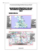
Geography Coursework: Whitewell Brook: To what extent does the discharge of the Whitewell Brook agree with theory? Location of study area. Here is a detailed view of the drainage basin of the Whitewell Brook. The drainage basin is clearly marked with the thick red line. Describing the characteristics of the Whitewell Brook drainage system. The Whitewell Brook drainage system is in the Pennines. It is a very complex system that flows into the River Irwell and then on into the Manchester Ship canal and then into the river Mersey which meets the Irish Sea at the Mersey Estuary. The land near the source of the river is mainly moor land used by farmers as rough grazing for sheep. This is poor quality and course grass. The source of the Whitewell Brook is on bent hill, this is very flat considering it is on top of a hill. We call this a PLATEAU. The plateau is about 350m above sea level but the highest tops range from approximately 350m-430m above sea level. The Whitwell Brook is roughly 5 miles long. It is very narrow at the source (see figure 1.5) and takes up most of the valley floor. The side of the valley are V-shaped. Towards the end of the Whitewell Brook the channel gets wider and the river takes up less of the valley floor because it is a lot wider (see figure 1.6). The river flows down approximately 200metres, this is spread evenly, and we know this because there

"Rivers in rural areas are much more natural than those in urban areas".
INTRODUCTION The title I have chosen for my coursework is "rivers in rural areas are much more natural than those in urban areas". I have chosen this title mainly because it interests me more than the other titles. This is the only physical topic, and so it interests me more than any of the others. This project involves me in to going to an urban area, Bexley-Village, to examine a river and to go to examine a river in a rural area, which would be South-Darenth. MAP OF BEXLEY Bexley village is a small village in Kent, South East England. MAP OF SOUTH-DARENTH South Darenth is a small town not too far away from Bexley village. There are three or four different types of data, which I will need to collect. They are the width and depth of the river, data about the wildlife in and near the river, pollution in the river, and finally vegetation, which grows in or near the river. I will have to record the width and depth of the river in different parts of it, to see how the information varies. If the river does vary often then we are probably looking at a river in more of a rural area. This is because in an urban area the banks of the river are sometimes been reinforced so that it does not erode. Some of the rivers have been reinforced to change the direction in which the river flows. An example of this is the river shuttle; it had been reinforced because otherwise it would
Flooding, one of the most disastrous natural hazards.
Geog Summer Assignment- Essay Question 2 Stella Kwok (7) Flooding is one of the most disastrous natural hazards. Take Huang He Basin in China as example, originally, intense rainfall in summer is one of the main causes of flood. With rapid urbanization and population growth, the built environment and the socio-economic characteristics is getting more important in contributing to flood hazards. To minimize the impact of flooding, take Huang He Basin in China as example, some preventive measures, such as flood control projects, are carried out. Flooding refers to the inundation by water of any land area not normally covered with water owing to a relatively rapid change of the water level. It often happens in the lower course of Huang He Basin. Firstly, physical environment is one of the main factors leading to flooding. Meteorologically, snowmelt in the upper course in spring causes sudden increase in discharge and blocking of ice-floes in river channels. In summer, the rainfall is concentrated in July and August, being highly variable. Prolonged and abnormally high rainfall may also increase the discharge of lower course of Huang He, allowing the floodwater to overflow its banks. The climatic condition throughout the year leads to the occurrence of flood. Topographically, there is a sudden decrease in gradient at Kaifeng, between the Loess Plateau and the
The aim of this project was to study the physical development of a river, from its early beginnings at its source in the mountains to the point where it joins its larger branches as it matures and courses its way to the sea.
Geography Coursework INTRODUCTION The aim of this project was to study the physical development of a river, from its early beginnings at its source in the mountains to the point where it joins its larger branches as it matures and courses its way to the sea. I chose this particular site, in the Cairngorm Mountains of Scotland, because of its accessibility (the river Luineag is situated 50 kilometers SE of Inverness and 85 kilometers W of Aberdeen. It is also 10 kilometers off the A9) and its beautiful scenery. The reserve holds many of the tributaries to the river Spey. The Cairngorm Mountains are the largest stretch of continuous upland wilderness in the UK, and the entire range is Britain's largest natural treasure. It stands at an altitude of 305 to 1108meters and is wild and dramatic land straddling the Spey and Dee valleys. The artic-alpine terrain of the high plateau is very similar to the landscape of northern Europe towards the end of the last Ice age. The region has however become an increasingly popular center for climbing, walking and skiing- thereby threatening the weak and fragile ecology of its ancient pinewoods, lochs and moors. Of particular note is the Golden Eagle, which is now on the brink of extinction. These mountains are the eagles' last British strongholds. Now large parts of it is protected by European Environment Law and is obliged to operate a