Porosity and permeability.
Porosity and permeability coursework The vast majority of geological materials can hold water to a greater or lesser extent, the amount of water if affected by the materials porosity and permeability. Porosity is a parameter that describes the amount of open space in geologic material, it can be stated as either a fractional value or percentage of the material that is open space. This open space is not however a void like the interior of a balloon it is more like a sponge with small air bubbles and interconnecting pores. These open pore spaces occur between sediment grains, in cracks or fractures and also on a larger scale in cavernous openings formed by dissolution of rock. The porosity values of rock typically range from 0-50%, this space is often filled with water or air or mixture of both. Permeability is closely linked to porosity as permeability is a parameter that describes the ability of geological material to transmit water. Permeability is measured in Millidarcy (MD) or Darcies (D). A Millidarcy is 1/1000 of a Darcy. A Darcy is the permeability that will allow a flow of 1 cubic centimetre per second of a fluid with 1 centipoise viscosity through a distance of 1 centimetre through an area of 1 square centimetre under a differential pressure of 1 atmosphere. The greater the permeability of a rock, the easier it is for fluids to flow through it. Typical permeability
Economic Analysis of the Tourism Industry in Hong Kong
Faculty of Business and Law Group Assignment Authentication Declaration Unit Code : MEE 781 Economics for Managers Unit Coordinator : David Neath Assignment No. : Two (2) Due Date : 28 October 2002 Group No. : Five (5) Student Names: CHAN, Shuk Ning Irene Student I. D.: 201061022 CHEUK, Chris Chi Ho Student I. D.: 100169977 KELSEY, Peter Wayne Student I. D.: 201135295 NG, Lily Student I. D.: 100328934 NGAI, Ka Mei Student I. D.: 97659508 TAY, Mui Lim Serene Student I. D.: 100167885 "We hereby declare that the material submitted in this assignment is our own work except where specifically acknowledged and referenced." MEE 781 Economics For Managers Assignment 2 Group 05 CHAN, Shuk Ning Irene CHEUK, Chris Chi Ho KELSEY, Peter Wayne NG, Lily NGAI, Ka Mei TAY, Mui Lim Serene Economic Analysis of the Tourism Industry in Hong Kong Executive Summary Tourism is a crucial industry for Hong Kong. The Government has worked together with industry players to enable Hong Kong to preserve its competitive edge as one of the most popular tourist destinations and venue for hosting international conferences. This includes developing multi-faceted tourist attractions, relaxing of controls over entry of visitors and upgrading service quality and standards in Hong Kong. Despite the worldwide economic downturn, this industry has not

Investigation of the distribution and abundance off reshwater invertebrates in the Tillingbourne River at Abinger Hammeron Thursday, 17th of October 2002
Investigation of the distribution and abundance of freshwater invertebrates in the Tillingbourne River at Abinger Hammer on Thursday, 17th of October 2002 Introduction My research is about the distribution and abundance of freshwater invertebrates in the Tillingbourne River at Abinger Hammer at Surrey, England. Invertebrates are living organisms without backbones therefore there must be a number of factors, which affect the way they live and reproduce. The distribution of an invertebrate is partially affected by its environment. I chose to observe which species of invertebrates lived in the middle and at the edge of the riverbed- the river being their habitat. I feel that the three most important abiotic factors that contribute to the distribution and abundance of such invertebrates are the flow rate i.e. the velocity of the water, the temperature and the oxygen levels. As well as measuring these three things I did a kick sampling to see which different species I would be able to find in the invertebrates' habitat- the river. There were also various safety measures we took such as wearing gloves and waterproof clothing to protect us from any harmful diseases. We were instructed to handle all equipment gently and accurately to ensure that the results are as accurate as possible. The weather that day was quite sunny that day, which was useful for us because the sunlight

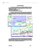
This investigation focuses on an area of the west bank of the medina estuary on the Isle of Wight.
Introduction This investigation focuses on an area of the west bank of the medina estuary on the Isle of Wight, located on fig. 0.1 + 0.2. The areas are located on the Medina Estuary one mile north of the town of Newport. I will be studying five areas along the bank; * Stag lane in the north * Dodnor creek * Dodnor hard * The Medina Valley Centre (MVC) * The Marine Transfer Facility (MTF) This investigation will be studying the environmental quality of the areas along a transect from Stag lane to the MTF and how the changing land uses affect these areas. My title is as follows; 'What is the impact of the changing human land uses on the environmental quality of the transect along the west bank of the Medina estuary from Stag lane to the MTF.' It is expected that when studying this area that the differing land uses will each have their own individual impact on the surrounding environment. Along the transect the area closer to Newport (the MTF) is more industrial and so would be expected to have a more negative impact on the environment. Whereas to the other end of the transect, (Dodnor creek) industry is limited due to its SSI status, and so the negative impact of land uses on the environment are expected to be limited. The focus will also be placed on how the land uses have changed over the years to show how the area has developed and how it is likely to develop in
Investigate the effects of costal processes on Porlock Bay in Somerset and also to investigate transportation along Porlock Bay.
- To investigate the effects of costal processes on Porlock Bay in Somerset - To investigate transportation along Porlock Bay. Introduction Place of study - Somerset, England, Population 447,000 The maps below shows the location of Somerset and Porlock Weir in the United Kingdom - I will investigate the effects of costal processes at Porlock Bay. Porlock Bay is situated on the west coast of England. Porlock Bay is in the county of Somerset and Bristol is the nearest major city, this is shown in fig 1. Somerset is in a national park, this means that the area is protected. The national park is called Exmoor national park. The national park area is a SSI; this means that the area is a site-specific interest. The SSI area means that the area is protected and there is only limited building at Exmoor National park. Somerset is a rural county in the UK. Tourism is very important in the county of Somerset. We visited Quantock Hill in the west of Somerset. The main settlements in this area are Minehead and Taunton; this is shown in fig 3. Fig 4 shows Porlock Bay in more detail. On this map you can see Hulstone Point and Gore Point as well as local services. Minehead and Taunton are where most of the services are available. Minehead and Taunton also contains many large settlements. Minehead has more people employed, as tourism is its main source of income. Minehead attracts

Underlying Causes of Deforestation and Forest Degradation in Kenya
Africa Underlying Causes of Deforestation and Forest Degradation in Kenya . Situation analysis Kenya's forests are rapidly declining due to pressure from increased population and other land uses. With half of the country being arid and semi-arid, there is a lot of strain on the rest of the land since the economy is natural resource based. The productive area which forms about 20% of the country's area falls in the medium and high potential agro-ecological zones and is under agriculture, forest and nature reserves. According to Forest Resource Assessment FAO 1990, Kenya is classified among the countries with low forest cover of less than 2% of the total land area. The dwindling forest cover has a severe effect on the climate, wildlife, streams, human population especially forest dwellers. .1 Introduction Mau Forest Complex is located in the Rift Valley province, about 200 km to the south-west of Nairobi and straddles four Districts: Kericho, Nakuru, Bomet, and Narok. It lies in the montane rain forest region which has a good potential for closed-canopy growth. The forest contains the largest remaining block of moist indigenous forest in East Africa covering an area of 900 km². The forest is gazetted and is under the managerial custody of the State's Forest Department. It was first gazetted in 1932 by the colonial government. Many alterations to the forest cover have
sustainable tourism in kenya
Sustainable tourism in kenya Kenya lies a long the East coast of Africa covering an area of 586,350 sq.km. with an estimated population of 26 million. Agriculture is the mainstay of the economy. Kenya is in the process of establishing a firm industrial base with import substitution and processing industries having been firmly established. The country aims at joining the newly industrialised nations status by the year 2020. Tourism is currently the second largest contributor to the economy after agriculture. Tourism in Kenya dates back to pre-independence days and history has it recorded that as early as the 1930's, overseas visitors and explorers had started coming to Kenya mainly for big-game hunting expeditions while others came in search of solitude. These expeditions were locally referred to by the Swahili word "Safari" thus bequeathing to the travel world literature with a new vocabulary. Among the early visitors were Statesmen, Royalties and celebrities such as Theodore Rosevelt, Her Majesty Queen Elizabeth II, and Ernest Hemingway respectively. At that time, there was already a relatively well developed but limited tourism infrastructure. The available accommodation was spartan but ideal for both the visitors as well as the settler community in Kenya. However soon after independence, the Kenya Government realised the enormous potential of the nascent tourism industry
In my studies I will try and determine how and why management strategies have been put in place at Brancaster in order to stabilise this stretch of coastline.
Purpose of Investigation In my studies I will try and determine how and why management strategies have been put in place at Brancaster in order to stabilise this stretch of coastline. By looking at four main objectives I will attempt to produce a holistic view of the processes taking place within the area, my lines of enquiry will include; • Why Brancaster needs managing? • What has been done in terms of management so far? • How effective these strategies have been? • What solutions or strategies might be seen within the future? Brancaster lies on the eastern coast of Britain within the county of Norfolk. Located approximately 7 miles East of Hunstanton, a major tourist town, on the A149, it demonstrates an excellent example of an area of outstanding natural beauty. The coastline itself along the periphery to the North of Brancaster town stretches for 4 1/2 miles and the area covers over 2000 acres of beach. The maps below identify the location of Brancaster... As North Norfolk currently is experiencing eustatic rises in sea level and local isostatic subsidence, localised flooding is becoming a great cause for concern. Together with being situated in an area directly within the path of North Sea Storm fetches and facing a northerly direction, the need for coastal defences and management of Brancaster's vulnerable coastline is becoming vital. Within this site

Erosion at Walton on the Naze
. CHAPTER1 As part of my GCSE coursework, my geography class and I had to visit Walton-On-The-Naze. We visited Walton on the 3rd of November 2000. I have to answer the question, 'Why is the rate of erosion so rapid at Walton-On-The-Naze?' I will try to answer this by studying a variety of coastal processes that are operating at Walton, e.g. the different types of sea defences, and use the theory behind it. I will use for example, the technical terms in my explanations with diagrams where possible. Walton is very close to the North Sea, and this is only one reason why erosion is so rapid. The cliffs have eroded by 4m since last year, and the largest amount it has eroded was 5.9 m in 1998 to 1999. The rapid rate of erosion is due to the many processes on its coast, effect of raw materials, wave size and fetch, depth and width of beach, longshore drift, where waves transport the material along the beach. Including mass movement e.g. small avalanches, rotational slips, weathering, and formation of wave cut platforms. My project will also involve lots of results from the tests we took, and evidence supporting it. In this first chapter, I will introduce Questions and Hypotheses which I will present as a list, the location of Walton, and then my aims and objectives. In most sections I will talk about the influencing factors, the technique, and the limitations and

River Steyr, Hinterstoder
Geography: River Course Work River Steyr, Hinterstoder October 2002 Vanja Ivancevic 11F Contents Page 1 - Title page Page 2 - Contents Page 3 - Introduction Page 4 - Introduction Page 5 - Base Map Page 6 - Strahlers Stream Ordering of the Steyr Page 7 - Relief Map of the Steyr Page 8 - Aims Page 9 - Hypothesis Page 10 - Theoretical Background Page 11 - Theoretical Background Page 12 - Data Collection Page 13 - Data Collection Page 14 - Data Presentation, Location 1, Description Page 15 - Data Presentation, Location 1-4, Bedload Sampling Page 16 - Data Presentation, Location 2, Description Page 17 - Data Presentation, Location 2, Tabular Data Page 18 - Data Presentation, Location 2, Graphical Data Page 19 - Data Presentation, Location 3, Description Page 20 - Data Presentation, Location 3, Tabular Data Page 21 - Data Presentation, Location 3, Graphical Data Page 22 - Data Presentation, Location 4, Description Page 23 - Data Presentation, Location 4, Tabular Data Page 24 - Data Presentation, Location 4, Graphical Data Page 25 - Data Analysis and Discussion, Location 1 Page 26 - Data Analysis and Discussion, Location 2, Hydraulic Radius and Discharge calculations Page 27 - Data Analysis and Discussion, Location 2, Spearman's Bedload/Velocity Rank Correlation Tabular data & Graph Page 28 - Data Analysis and Discussion,


