
My hypotheses are:The character of the course of the River Bollin will change along its course to the mouth. The bed load will decrease and angularity of the materials found in the river will be reduced. The velocity
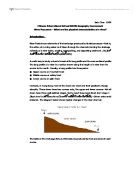
Chapter I, Introduction On Monday the twenty first of June, 2004, we went on a field trip to study the characteristics, and formation of a river, how it changes in its journey from source to mouth, including its load Our aim was to learn first hand about how a river changes and forms on the different types of land found in its course. I predicted that as the river went downstream, it would become consistently slower, cover a much larger wetted perimeter, and that the stones in its bed load would become increasingly rounded as it was ground into sand. This is my investigation into the changing characteristics of a river along its journey from the source to the mouth. This will include using my geographical knowledge to create hypotheses and test them out using the results gathered from our many tests upon the river. All the tests were kept the same to avoid spoiling of results. This diagram shows the accepted effects of a river on its course. With this diagram in mind, I based my three hypotheses on the things that this diagram state. My hypotheses are: . The character of the course of the River Bollin will change along its course to the mouth. 2. The bed load will decrease and angularity of the materials found in the river will be reduced. 3. The velocity and discharge will change along its course downstream. The sites Our study was of the River Bolin, at three
River Processes - What are the physical characteristics of a river?
Jack Chen 11KM Chinese International School IGCSE Geography Coursework River Processes - What are the physical characteristics of a river? Introduction: River Features are elements of the landscape produced by fluvial processes-that is, the action of running water as it flows through the channels forming the drainage network of a river basin, eroding, transporting, and depositing sediment. (Source from Microsoft Encarta Encyclopedia 2001) A useful way to study a river is to look at its long profile and its cross sectional profile. The long profile of a river is a section drawn along the length of a river from its source to its mouth. Usually, a long profile has three parts: ? Upper course or mountain tract ? Middle course or valley tract ? Lower course or plain tract However, in Hong Kong most of the rivers are short and their gradients change abruptly. These rivers have two courses only, the upper and lower courses. Not all rivers have three well-defined stages. Some reach base level direct from stage 1 (Base level is the lowest level down to where a river can erode). Others arise amid lowlands. The diagram below shows typical changes in the river channel: The table on the next page lists out the features produced by river processes in each course. The Long Profile of a River Upper Course Middle Course Lower Course * V shaped valley * Steep gradient *
The river Tees
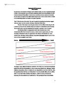
What evidence is there that the river Tees has a upper and lower course? The Tees is a river in Northern England. It rises on the eastern slope of Cross Fell in the Pennines, and flows eastwards for about 87 miles (137 km) to the North Sea, between Hartlepool and Redcar. It drains an area of 708 square miles (1834 square km), and subsumes no important tributaries. The river formed the boundaries between the historic counties of County Durham and Yorkshire. At its lower reaches it now forms the boundary between the ceremonial counties of County Durham and North Yorkshire. Like most rivers, the River Tee has an upper and lower course. The upper course is the start of the river. This is known as the source. The upper course is typically steep and straight with lots of fast flowing water. The source of the River Tees starts is journey in Cumbria at 600 metres above sea level. A succession of falls or rapids, where the river traverses a hard series of black basaltic rocks, is called "Cauldron Snout". From a point immediately below this to its mouth, the Tees forms the boundary between the traditional counties of Durham and Yorkshire almost without a break, although since 1974 much of it lies wholly in Durham. The dale becomes bolder below Cauldron Snout, and trees appear, contrasting with the broken rocks where the water dashes over High Force. These materials are materials
River Studies
Geography MYP Coursework River Studies Rio Lizandro is a river located in Portugal, near the district of Lisbon, and has an approximate length of 30km. In this coursework, we have to test the hypothesis related to the characteristics of the Rio Lizandro to discover if it is justified. In order to do so, we will have to draw, measure and calculate the data which we are give on four different sites along the river, and thus conclude with an analysis on the relationship between our results and the given hypothesis. Task 2: State the aim of the study. You need to explain the hypothesis and perhaps suggest what you expect to be the outcome referring to Bradshaw's Model River. The aim of this study is to use the given data on the four different sites along the Rio Lizandro to see how its river variables change and compare it to Bradshaw's model. By doing this, we will be able to test the hypothesis and conclude on whether or not it is correct. The Bradshaw Model is a geographical model which illustrates how a river's characteristics differ from the mouth to source, or lower course to upper course, of a river. According to Bradshaw's model, the hypothesis is that "Stream characteristics (i.e. cross-sectional area, discharge, velocity, efficiency, and gradient) all change along the course of the river and they are related to each other". Source

River Chess Coursework
River Chess Coursework My coursework involve a study of the river chess near Amersham. It is obviously based on the work that we did as part of the Rivers module. My work will show how this river changes as it moves downstream. Firstly, the River Chess springs from the Chess Valley in Chesham and Hertfordshire which is in South-East of England. The reason why we studied R. Chess is because the nearest river to us and it will be wise to take measurements of the size of a small river instead of a large e.g. Thames, where it will be difficult to take measurements. Chess River has a drainage basin of 105 square km that covers parts of Chesham, Buckinghamshire and Hertfordshire. Site 1: 1.5 km from source Site 2: 16km from source Site 3: 17 km From source It is important to study the rivers and systems, so we know what to expect and will be able to control them in different ways Leaves example - where the rivers it will not lead to a disaster to the surrounding villages as we all know that if a major river flood can cause devastation as when the Mississippi flooded in New Orleans in 2005. Therefore studying the history and the rivers we have Aid to bring about the prevention of floods. However, the study of rivers in the summer is different than in the winter because the river depth varies depending more rain in
Amazon River is the world's second longest river and the chief river of South America.
Amazon River is the world's second longest river and the chief river of South America. Only the Nile River in Africa is longer. The Amazon is 6,437 kilometres long. The Amazon carries more water than any other river--more than the Mississippi, Nile, and Yangtze rivers together. The Amazon is too wide at many points for a person on one bank to see the opposite shore. The river ranges from 2.5 to 10 kilometres wide during most of its course. It widens to about 150 kilometres at its mouth. The depth of the Amazon averages about 10 metres and increases to more than 90 metres at some places. The Amazon River Basin covers about 7,000,000 square kilometres and is the world's largest tropical rainforest. The temperature averages 29 °C and varies little throughout the year. Rainfall in the Amazon region ranges from 130 centimetres in the low-lying areas to 305 centimetres near the Andes Mountains in Peru. The air is very humid throughout most of the river basin. Most ships enter the Amazon River by way of the Para River, on the southern side of Marajo Island. Ocean vessels can sail about 3,700 kilometres up the Amazon to Iquitos, Peru. Belem, at the mouth of the Para River, and Manaus, 1,600 kilometres upstream from the mouth of the Amazon, are important ports. Ships bring in clothing, food, tools, and other products. They pick up such raw materials as animal

To investigate changes in bed load and discharge along the course of the river Shimna.
A fieldwork investigation into changes in bed load and discharge from source to mouth in the river Shimna. Aim: To investigate changes in bed load and discharge along the course of the river Shimna. I expect that as you move from the source to the mouth the discharge of the river will increase. This is possibly due to tributaries coming together and the river channel becoming wider. Also as I move downstream I will expect the rivers bed load to decrease in size and to become more rounded due to erosion processes such as attrition . Through my investigation I will either be able to prove or disprove the following hypothesis; Hypothesis 1- the size and shape of river bed load will change from source to mouth, becoming smaller and more rounded due to the process of erosion. Hypothesis 2- discharge will increase from source to mouth. Planning: For this piece of coursework to be carried out successfully some time had to be allocated to planning the trip. Due to the nature of the fieldwork, i.e. the fact it was a river study, safety was an important issue. Firstly a relatively safe and manageable river had to be chosen. The river Shimna fulfilled this requirement and also was suitable as the centre could provide us with transport, weatherproof clothing and also someone with first aid skills in case of an emergency. This would be vital in case of unfavourable weather conditions
Geograpgy glendun river
Contents Page 1 Front cover Page 30 Location - map showing bed load distribution Page 2 Contents Page 31 Evaluation Page 3 Section 1 - Applied understanding Page 32 Evaluation Page 4 Location Page 33 Evaluation Page 5 Location - map Page 34 Evaluation Page 6 Theory - Ideal stream Page 35 conclusion Page 7 Ideal stream table Page 36 Bibliography Page 8 We should expect to find at: Upper course Page 37 Appendix Page 9 Middle course Page 10 Lower course Page 11 Glossary Page 12 Glossary Page 13 Methodology Page 14 Equipment used Page 15 Data table Page 16 A comprehensive range of techniques Page 17 A comprehensive range of techniques Page 18 Originality Page 19 Results and analysis - Hypothesis 1 Page 21 Results and analysis - Hypothesis 1 Page 22 Results and analysis - Hypothesis 1 Page 23 Results and analysis - Hypothesis 1 Page 24 Results and analysis - Hypothesis 1&2 Page 25 Hypothesis 2 Page 26 Hypothesis 3 Page 27 Hypothesis 3 Page 28 Conclusion Page 29 Originality GCSE Geography Coursework Section 1 - Applied understanding Why? We are doing this study to test all the text book theories. It brings all the ideas that we read in a book to real life, we can see exactly what happens for ourselves we get the chance to record the results ourselves also this is a requirement for our geography GCSE and the study is worth 25% of our

River study - Burbage Brook,
Plateau The plateau is the source of Burbage Brook, which is a fairly large are of high flat land. This is formed by heavy rainfall soaking into the peat, which then filters into the brook. Upper Burbage Brook The upper area of Burbage Brook is a 'V-shape' with very steep sides. This is caused due to the steep gradient of the riverbed that then leads to a high velocity of the river causing rapid vertical erosion to take place (refer to the bar chart to explain the velocity of upper Burbage Bridge.) This combined with weathering creates a 'V-shape' valley. Deposition here is very minimal, as it is only the first flowing currents. The type of weathering that you are likely to find at this area of the valley is 'freeze-thaw weathering'. This is when water gets into the cracks in the rock, expands (freezes) which then puts pressure on the rock eventually causing chunks of the rock to break off leading to a form of mass movement (Rock Creep). Middle Course of Burbage Brook The middle course of Burbage Brook is a 'V within a V' shape. The valley is slightly wider here than the upper course of Burbage Brook also the valley sides are much gentler. It also meanders side to side caused by interlocking spurs (look at the diagram below about a meander). The valley sides widen due to lateral erosion. Lateral erosion takes place here because the velocity of the river is much

Cross section of a river
Upper-course Middle-course Lower-course In the upper-course of the river we saw interlocking spurs. These are formed when the river doesn't have enough energy to erode the banks, and is forced around them instead. The river valley was v-shaped and the relief was steep. V-shaped valleys are caused when the river in the upper-course only has enough energy to erode vertically and so a deep gorge is formed. Weathering on the rock walls of the gorge weaken them and cause large chunks of rock to fall into the gorge, eventually forming a v-shaped valley. Rocks in the upper-course of the river are large and angular because, being new to the river; they have undergone minimal attrition in comparison to rocks in the middle and lower-course. These rocks cause friction lowering the discharge in the upper-course. Another factor in the discharge of the river is whether the rock is impermeable or permeable. In Holford Combe, although the rock below the river (red sandstone) was impermeable, it was fractured allowing infiltration. This fracturing was due to the same tectonic plate movement that formed the Alps. Another feature found in the upper-course of rivers are waterfalls. These are formed when water passes over hard rock, eroding softer rock below. This forms a plunge pool where water and bedload swirl around, eroding the river backwards through abrasion and hydraulic action.


