Why does Green Peace want Antarctica as a World Park?
Christian German 8A Why does Green Peace want Antarctica as a World Park? Antarctica has become a unique place in the modern world, the only continent that remains relatively untouched by human interference and therefore arguably the only pristine wilderness left on Earth. For Greenpeace it seemed imperative to keep it that way. Some ecologists have even argued that Antarctica could provide important information for future generations seeking to reverse the environmental degradation wrought by humanity in the Twentieth Century. Paradoxically, despite winds of up to 450 kilometres per hour and temperatures reaching -50C Antarctica has the most delicate ecosystem of any place on earth. Ever since humankind began to explore the continent, from Amundsen and Scott's famous battle to the South Pole onwards, it had been noted that Antarctic ecosystems take years to recover from damage if they recover at all: a footprint in the moss can linger for decades before it disappears. This proposed World Park can also protect the delicate ecosystem like the Antarctic Treaty but even better let scientists make experiments while not harming the environment to see ways on how to deal with climate change. This shows it would be better for Antarctica to become a World Park because the animals will get a better protection from all those people in there while without it will just encourage

Earthquake in Kobe – A Natural Disaster Waiting to Happen
h/w Saturday, 05 October 2002 Earthquake in Kobe - A Natural Disaster Waiting to Happen Introduction It all happened on the morning of January the 17th 1995, the second most populated and industrialized city in one of the biggest economies of the world, was struck by a powerful earthquake causing thousands of injuries and hundreds of deaths. It was a disaster waiting to happen. Situated in the south-central region of Japan, Kobe was the second largest city in Japan people and industrial-wise, after Tokyo. It was the biggest earthquake to hit Japan, after the great Kanto earthquake of 1923, where around 140,000 people were killed, most after the impact. The strong shock occurred across the fault that runs through the city of Kobe, and the Awaji island. The earthquake lasted for around 20 seconds, with around 5,500 deaths resulting from it. The number of injuries reached about 35,000 in total, and nearly 180,000 buildings were said to have collapsed. The damage was recorded over a radius of 100 km from the epicentre. The earthquake also hit the cities of Osaka and Kyoto. The economic loss was worse than anything. It was the largest ever to be lost directly from a natural disaster. Directly from the shaking itself, around 13 trillion yen worth of damage was caused. This is around £100 billion and before, the loss of life, production, and business

River Chess Coursework
River Chess Coursework My coursework involve a study of the river chess near Amersham. It is obviously based on the work that we did as part of the Rivers module. My work will show how this river changes as it moves downstream. Firstly, the River Chess springs from the Chess Valley in Chesham and Hertfordshire which is in South-East of England. The reason why we studied R. Chess is because the nearest river to us and it will be wise to take measurements of the size of a small river instead of a large e.g. Thames, where it will be difficult to take measurements. Chess River has a drainage basin of 105 square km that covers parts of Chesham, Buckinghamshire and Hertfordshire. Site 1: 1.5 km from source Site 2: 16km from source Site 3: 17 km From source It is important to study the rivers and systems, so we know what to expect and will be able to control them in different ways Leaves example - where the rivers it will not lead to a disaster to the surrounding villages as we all know that if a major river flood can cause devastation as when the Mississippi flooded in New Orleans in 2005. Therefore studying the history and the rivers we have Aid to bring about the prevention of floods. However, the study of rivers in the summer is different than in the winter because the river depth varies depending more rain in
Outline the factors influencing a rivers flood hydrograph.
Outline the factors influencing a rivers flood hydrograph. A flood hydrograph shows river discharge over a period of time. It shows the response of a river to a specific rainfall event. There is usually a time-lag between the peak rainfall intensity and peak flood flow. There are a number of factors that influence a flood hydrograph. A flood hydrograph is split in two, with the baseflow (which is mostly groundwater flow through rock) and the stormflow (overland flow, throughflow and direct channel precipitation) stormflow accounts for most of the hydrograph. The graphs different shapes depend on a number of things, the flatter hydrographs tend to occur if the storm is light whilst the steep ones when there has been a lot of overland flow. One factor that impacts the graph is the type of bedrock. Bedrock can be permeable or impermeable. Impermeable bedrock, like shale, does not allow water to pass though it whilst permeable rocks such as chalk does. There are two types of permeable rock; porous, which contains pours that fill with and store water as well as pervious. Pervious bedrock is cracked and so allows water to run in its joints. An example of this is carboniferous limestone. A basin with impermeable bedrock is likely to produce a much more dramatic hydrograph than one with permeable bedrock. The basins drainage density is another factor. Drainage density is defines

Yellowstone Supervolcano
A super volcano is a mega colossal volcano that erupts at least 1,000km3 of material. Super volcanoes do not look like a volcano with a characteristic cone. Instead, they have a large depression called a caldera, often marked by a rim of higher land around the edges. Beneath the caldera is a huge magma chamber, where all the magma is stored before the volcano erupts. Yellowstone is a super volcano in Montana, North America. There is evidence that the magma beneath Yellowstone is shifting. The caldera is bulging up at one end beneath Lake Yellowstone. There are signs of increasing activity at Norris, and the ground has risen as much as 70cm in some places. The magma chamber beneath Yellowstone is believed to be 80km long, 40km wide and 8km deep. It is not known whether the magma is on top of other materials, which would be necessary for an eruption. If Yellowstone, or any other super volcano did erupt, there would be many major effects globally. An eruption is likely to destroy 10,000km2 of land, kill 87, 000 people, and 1 in 3 people affected would die. Ash would be deposited all over the United States, which would affect transport, electricity, water and farming. Harvests would disappear instantly, leaving many people hungry, and the water supplies would get contaminated, leaving hundreds of thousands of people without clean water. Global climates would change, which may

Why is Antarctica so important?
The last great wilderness is very important to us and to everyone else. This unique, wonderfully, and beautiful place is a place almost entirely covered with snow and ice, it maybe doesn't look like the most important thing in the world but it is one of those things that is made important. The continent of Antarctica is important to us because it has become an international science laboratory where scientists study its weather and climate, oceanology, meteorology, astronomy, ozone layer, marine life and geology. We are only now beginning to realize the profound effects that Antarctica has on our environment and way of life. Antarctica may hold the key to understanding food chains, and the role of plankton in those chains. It is possible that these small organisms form the base of the ecosystems that support all living things. The continent of Antarctica is also important because it is thought to have large deposits of valuable mineral resources including platinum, gold and silver. Coal in commercially attractive deposits has been found, but no other minerals are known to exist in potentially useful amounts. Large deposits of oil and natural gas are believed to exist in Antarctica's continental shelf. In understanding global change the Antarctic has a crucial role to play. Locked up in its 4 km thick ice sheet is a record of past climate for the last 500,000 years.
Letter about a volcanos DRAFT
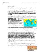
Dear Senor Jose Cruz You asked me to find out about your volcano poco-poco. I am going to tell you where volcanoes occur and why they erupt in these places, the dangers of them and the dangers of them happening in Mount Isle, what happens when they erupt and the process of getting to the eruption, why volcanoes erupt in the Caribbean region, other examples of eruptions in the Caribbean region, how scientists can monitor and predict volcanic eruptions, why there has been little research on Poco-poco in the past and how the citizens of Iguana Cay could prepare for a possible eruptions and what they should do in the event of an eruption. Volcanic eruptions occur only in certain places in the world and do not occur randomly. That's because the Earth's outermost shell is broken into a series of slabs known as tectonic plates. These plates are rigid, but they float on the hotter, softer layer in the Earth's mantle. There are 16 major plates as you can see in the map. As the plates move about, they spread apart, collide, or slide past each other. Volcanoes occur when this movement occurs. As you can see the Caribbean is next to a plate boundary. This explains why eruptions happen in this area. There have been several eruptions in the Caribbean region such as Montserrat in 1995. St. Kitts has erupted 27 times and St. Eustatius last erupted 1,600 years before present. Future volcanic
Mount Sakurajima volcano report.
By Joseph Hemingway Location: Kyushu, Japan Height: 3,665ft Type: Stratovolcano - also called a composite volcano, is a tall, conical volcano composed of many layers of hardened lava, tephra, and volcanic ash. Last Eruption: 2007 914 * The 1914 eruption has been the most powerful in the Japanese twentieth century. * During the eruption lava flows filled in the narrow strait between the island and the mainland, converting it into a peninsula. * Before 1914, the volcano had been dormant for over a century. * The eruption began on 11 January 1914. * Almost all residents had left the island in the previous days, in response to several large earthquakes which warned them that an eruption was imminent. * Initially, the eruption had been very explosive, generating eruption columns and pyroclastic flows, but after a very large earthquake on 13 January 1914 which killed 35 people, it became effusive, generating a large lava flow. * Lava flows are rare in Japan-the high but the lava flows at Sakurajima continued for months. * The island grew, engulfing several smaller islands nearby, and eventually becoming connected to the mainland by a narrow isthmus. Recent Activity * The volcano resumed activity in 1955, and has been erupting almost constantly ever since. * Thousands of small explosions occur each year, throwing ash to heights of up to a few kilometers above the
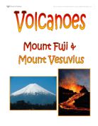
Volcanoes - Comparing Mount Fuji and Vesuvius
Volcanoes Location Page 1 Why did they erupt? Page 2 Human Impact Page 3 Physical Impact Page 4 Similarities & Differences Page 5 Conclusion Page 6 Bibliography Page 7 The volcano, Fuji, is found on the southern Honshu Island in Japan. It is the largest and most popular volcano in Japan, rising to 12,388 feet (3,776 m) above sea level and has a perimeter base of 50km. Fuji is a typical cone shaped volcano and has kept its shape for around 5,000 years. Fuji consists of three different volcanoes called Komitake, Ko-Fuji and Fuji which lie one upon the other. Mount Vesuvius is a volcano in the east of Naples in Italy. The volcano is over 17 000 years old and is still at this moment, active. It is only 4190 feet tall (1277 m) with a base of 48km (3 miles) but its past eruptions have been very dangerous, killing a vast amount. So far Vesuvius has had 50 eruptions and in only one of these eruptions, it has killed over 3 000 people. The volcano is moderately young but has erupted several times and most of these eruptions have been somewhat large in size, but overall, Fuji has had 2 mainly damaging eruptions. Any volcanic eruption is normally caused by plate boundaries. Mount Fuji is an island-arc volcano which means that three
Discuss the environmental imapact of Mt. St. Helens tectonic eruption.
Discuss the environmental impact of a Mount St. Helens tectonic event. Introduction Mount St Helens is an active volcano, south-western Washington in the Cascade Range. The volcano which had been dormant since 1857, began to show signs of renewed activity in early 1980. On May 18 1980, it erupted with such violence that the top of the mountain was blown off and a cloud of ash and gases was sent to an altitude of 19 km (12 mi). The blast killed 57 people and destroyed all life in an area of some 180 sq km (70 sq mi); an even wider area was covered with ash and debris. It continues to emit ash and steam intermittently. As a result of the eruption, the mountain's elevation was decreased from 2,950 m (9,677 ft) to 2,550 m (8,365 ft). A National Volcano Monument was established here in 1982. May 18th 1980 a kryptodome appeared on the north side of the volcano, before this the volcano hadn't erupted for over 120 yrs. March 20th an earth quake happened right underneath the volcano signalling an eruption. Unfortunately Lavafrom the last eruption had acted as a plug, and blocked the volcano. Magma was rising at a rate of six feet a day, casing a bulge on the side of the mountain (Kryptodome). Scientists were using GPS (global Positioning satellites) to monitor the Volcano. March 31st state of emergency announced, 20m exclusion zone was placed around the volcano. May