Debden Brook Rivers Cousework Analysis and Conclusion
Analysis and Conclusions In this section I intend to analysis my results and state whether my hypothesis were verified (proved correct) or nullified (proved incorrect) I will provide reasons as to why by showing a detailed analysis of actual figures from my graphs. In the second part of this section I will evaluate the results by looking at factors that could have affected the accuracy of my results and conclusions i.e. limitations. I shall look at ways in which my methods might have been improved. I must also look at the Bradshaw model and see if the characteristics of this specific river follow the general trend of his model. Hypothesis 1 - The Width of the River Increases with Distance Downstream This hypothesis was proved correct because figure one shows that the width of the river steadily increases with distance downstream. The water width of the river increased from 0.83m at site 1 (Debden Brook) to 1.95m at site 2 (Debden Brook) and 8.53m at site 3 (The River Roding). This is because streams generally carry more water in their channel as distance from the source increases because water is added to them from tributaries, however there are some exceptions (e.g. The River Mersey due to human activity). This will also increase lateral erosion as the water will be moving faster and carrying more load. As a result, the width increases. This hypothesis corresponds
How can urban living be sustainable
How can urban living be sustainable? Urban living means living in a city or town or a densely populated area. A sustainable city is an urban area where residents have a way of life that will last a long time. The environment suffers minimal damage, economic, historic and social factors should also be able to stand the test of time. However one area or building can be sustainable and eco-friendly but the scale is only very small so isn't a lot of use in the long run. In cities and towns presently and in the future, we will have a number of issues facing us to make a sustainable city. Some of these issues are; waste disposal, efficient public transport, housing, energy supplies, supporting local businesses and protecting our natural environment. Waste Disposal Waste disposal is one of the biggest issues facing us. The only reason it is an issue is because there is too much waste. We are running out of ways to dispose it; that is suitable, cheap and sustainable. At the moment, each person throws away about 450kg of rubbish yearly. This means that over 111 million tonnes of rubbish end up in landfill sites around the UK. Landfill is the most common method of disposing waste; over 64% of our bin rubbish ends up in a landfill site (excluding industrial, business, and hospital waste). A landfill is carefully structured to isolate it from the surrounding environment
Why does Green Peace want Antarctica as a World Park?
Christian German 8A Why does Green Peace want Antarctica as a World Park? Antarctica has become a unique place in the modern world, the only continent that remains relatively untouched by human interference and therefore arguably the only pristine wilderness left on Earth. For Greenpeace it seemed imperative to keep it that way. Some ecologists have even argued that Antarctica could provide important information for future generations seeking to reverse the environmental degradation wrought by humanity in the Twentieth Century. Paradoxically, despite winds of up to 450 kilometres per hour and temperatures reaching -50C Antarctica has the most delicate ecosystem of any place on earth. Ever since humankind began to explore the continent, from Amundsen and Scott's famous battle to the South Pole onwards, it had been noted that Antarctic ecosystems take years to recover from damage if they recover at all: a footprint in the moss can linger for decades before it disappears. This proposed World Park can also protect the delicate ecosystem like the Antarctic Treaty but even better let scientists make experiments while not harming the environment to see ways on how to deal with climate change. This shows it would be better for Antarctica to become a World Park because the animals will get a better protection from all those people in there while without it will just encourage
Development Case Study - Dharavi, Mumbai, India.People want to redevelop in Dharavi as it is situated in the heart of Mumbai, very close to the CBD on extremely valuable ground. Which in their eyes is being "wasted" by using it as a slum.
Name Sean Tuffy Case Study - Dharavi, Mumbai, India. Two news articles and links to various websites related to Dharavi can be found on: http://www.geographyalltheway.com/igcse_geography/population_settlement/settlement/squatter_settlements.htm Where in the world is Dharavi? It is in Mumbai, India, located extremely close to the CBD on a very valuable 175 hectares of land. Describe the location of Dharavi? Dharavi is one of the largest slums in the world, with a populaton of about 800,000 spread over 0.67 square miles. It is sandwiched between two of Mumbai's suburban railway lines, the Western and Central Railways, it is also extremely close to Mumbai's CBD making it very valuable. Briefly describe the history of Dharavi? Dharavi was once an island in the 18th century, which was made up of mangrove swamp where fishermen lived, but in the 19th century the swamps began to vanish and consequently so did the fishing industry. Soon after several other separate islands in the region began joining together to form one big island, this was helped by a big dam at Sion which significantly slowed water flow down. These now dry marshes were perfectly suited for residential use and migrants soon established a colony, first the Gujarat, followed by many others. In the 1920s the area had a large influx in migrants. Dharavi's first ever school was built in 1924 and was the only

Earthquake in Kobe – A Natural Disaster Waiting to Happen
h/w Saturday, 05 October 2002 Earthquake in Kobe - A Natural Disaster Waiting to Happen Introduction It all happened on the morning of January the 17th 1995, the second most populated and industrialized city in one of the biggest economies of the world, was struck by a powerful earthquake causing thousands of injuries and hundreds of deaths. It was a disaster waiting to happen. Situated in the south-central region of Japan, Kobe was the second largest city in Japan people and industrial-wise, after Tokyo. It was the biggest earthquake to hit Japan, after the great Kanto earthquake of 1923, where around 140,000 people were killed, most after the impact. The strong shock occurred across the fault that runs through the city of Kobe, and the Awaji island. The earthquake lasted for around 20 seconds, with around 5,500 deaths resulting from it. The number of injuries reached about 35,000 in total, and nearly 180,000 buildings were said to have collapsed. The damage was recorded over a radius of 100 km from the epicentre. The earthquake also hit the cities of Osaka and Kyoto. The economic loss was worse than anything. It was the largest ever to be lost directly from a natural disaster. Directly from the shaking itself, around 13 trillion yen worth of damage was caused. This is around £100 billion and before, the loss of life, production, and business

River Chess Coursework
River Chess Coursework My coursework involve a study of the river chess near Amersham. It is obviously based on the work that we did as part of the Rivers module. My work will show how this river changes as it moves downstream. Firstly, the River Chess springs from the Chess Valley in Chesham and Hertfordshire which is in South-East of England. The reason why we studied R. Chess is because the nearest river to us and it will be wise to take measurements of the size of a small river instead of a large e.g. Thames, where it will be difficult to take measurements. Chess River has a drainage basin of 105 square km that covers parts of Chesham, Buckinghamshire and Hertfordshire. Site 1: 1.5 km from source Site 2: 16km from source Site 3: 17 km From source It is important to study the rivers and systems, so we know what to expect and will be able to control them in different ways Leaves example - where the rivers it will not lead to a disaster to the surrounding villages as we all know that if a major river flood can cause devastation as when the Mississippi flooded in New Orleans in 2005. Therefore studying the history and the rivers we have Aid to bring about the prevention of floods. However, the study of rivers in the summer is different than in the winter because the river depth varies depending more rain in
Causes and Effects of Migration
Causes and Effects of Internal and External Migration Migration is the movement of people from one place to another. We can divide it into two different parts. Internal migration which is rural(towns) to urban(cities). For example, Oakham to Manchester and external migration also can be said as international migration which is the movement from one country to another. For example, Turks to Germany or Mexicans to USA which I am going to talk about it as we go on. People migrate for two reasons. Firstly, they may wish to get away from the things that they do not like. These are called push factors and include:- * not enough and poorly paid jobs * old and poor quality houses * natural disasters - earthquakes, volcanoes, wars * few oppotunities - shopping centers, cinema, food, schools, hospitals * poor transport Secondly, people are attracted to the things that they do like. These are called pull factors and include:- * more and better paid jobs * new and good quality houses * better education - more oppotunities * improved medical care * better transport Now I am going to talk about the rural-urban migration in Britain. During the Industrial Revolution of the nineteenth century, many people in Britain were either forced to leave the countryside caused by push factors or attracted to the growing towns caused by the pull factors. Between about 1930 and 1980 there
Tourism in Greece
Info about tourism in Greece Greece mainland and the Greek islands are one of the favourite holiday destinations in Europe. In fact, Greece comes in the 15th place in the world rating of tourist destinations, since, according to the National Statistical Service of Greece, it receives more than 15 million tourists every year, after countries such as the USA, China, Spain and Great Britain. Most tourists come to Greece from Europe, especially the EU countries, and from the USA, while fewer originate from the other continents. In 1989 and 1991, approximately 90% of the tourists to Greece were Europeans, in particular German and British citizens. Until the mid-1990s, the tourism flow in Greece would not surpass 8 or 9 million; however, 1994 was a determinant year for Greek tourism because more than 10 million people chose Greece and the wonderful Greek islands to spend their summer vacations. Greece is a famous country, popular for its clean beaches and its long history. There are hundreds of archaeological and historical sites to visit in Greece that gloriously depict the country's past. Its landscape is mainly mountainous and the terrain is not very fertile, except for some valleys scattered along the Greek mainland. However, Greece is surrounded by water, in particular the Aegean and the Ionian Sea. The country consists of more than 1,400 islands and islets, but only 169 of
Outline the factors influencing a rivers flood hydrograph.
Outline the factors influencing a rivers flood hydrograph. A flood hydrograph shows river discharge over a period of time. It shows the response of a river to a specific rainfall event. There is usually a time-lag between the peak rainfall intensity and peak flood flow. There are a number of factors that influence a flood hydrograph. A flood hydrograph is split in two, with the baseflow (which is mostly groundwater flow through rock) and the stormflow (overland flow, throughflow and direct channel precipitation) stormflow accounts for most of the hydrograph. The graphs different shapes depend on a number of things, the flatter hydrographs tend to occur if the storm is light whilst the steep ones when there has been a lot of overland flow. One factor that impacts the graph is the type of bedrock. Bedrock can be permeable or impermeable. Impermeable bedrock, like shale, does not allow water to pass though it whilst permeable rocks such as chalk does. There are two types of permeable rock; porous, which contains pours that fill with and store water as well as pervious. Pervious bedrock is cracked and so allows water to run in its joints. An example of this is carboniferous limestone. A basin with impermeable bedrock is likely to produce a much more dramatic hydrograph than one with permeable bedrock. The basins drainage density is another factor. Drainage density is defines
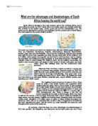
What are the advantages and disadvantages of south africa hosting the world cup 2010?
What are the advantages and disadvantages of South Africa hosting the world cup? South Africa is situated in the most southern part of the continent Africa, and is now hosting the world cup 2010. South Africa has hosted events any football events like this, however it has hosted rugby, cricket, grand prix and the confederations cup. The world cup has affected the economy, the population and the environment of South Africa, the main impact for the country itself is tourism. The world cup matches are held in ten stadiums they will seat 570000 people altogether. They are Polokwane, Rustenburg, Pretoria, Johannesburg, Nelspruit, Bloemfontein, Durban, Cape Town and Port Elizabeth. Five of the ten hosting the matches have already been built, but have been upgraded; the other five are newly built. All the stadiums cost £1.9 billion, which people may arguably say that that it could have been used on helping the population and treating the large population of south Africa that have HIV/AIDS. The changes made to accommodate the stadiums were, all the building surrounding the stadium were knocked down and people in their houses in Durban were given one week notice, along with buildings trees and the environment were destroyed. Whenever there has been a world cup held in a country, the majority of outcomes were positive. Germany world cup 2006 'The world Cup had a very positive effect