Letter about a volcanos DRAFT
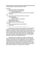
Dear Senor Jose Cruz You asked me to find out about your volcano poco-poco. I am going to tell you where volcanoes occur and why they erupt in these places, the dangers of them and the dangers of them happening in Mount Isle, what happens when they erupt and the process of getting to the eruption, why volcanoes erupt in the Caribbean region, other examples of eruptions in the Caribbean region, how scientists can monitor and predict volcanic eruptions, why there has been little research on Poco-poco in the past and how the citizens of Iguana Cay could prepare for a possible eruptions and what they should do in the event of an eruption. Volcanic eruptions occur only in certain places in the world and do not occur randomly. That's because the Earth's outermost shell is broken into a series of slabs known as tectonic plates. These plates are rigid, but they float on the hotter, softer layer in the Earth's mantle. There are 16 major plates as you can see in the map. As the plates move about, they spread apart, collide, or slide past each other. Volcanoes occur when this movement occurs. As you can see the Caribbean is next to a plate boundary. This explains why eruptions happen in this area. There have been several eruptions in the Caribbean region such as Montserrat in 1995. St. Kitts has erupted 27 times and St. Eustatius last erupted 1,600 years before present. Future volcanic

Investigating travel and tourism. Accomodation, transport and attractions.
Unit 1 - Investigating Travel and Tourism Assignment 1 (P1+ M1) Task 1 (P1) Domestic tourism- domestic tourism is when tourists live in the UK and take holiday in the UK this is usually one night or more, it can also be day trips. An example of domestic tour operators is: Haven and Butlins. Travel companies in the UK are companies such as National express coach services, Great western railway. Inbound tourism- inbound tourism is when tourists live outside of the UK and travel to the UK. Inbound tour operators include All European travel, Marriot hotel. Travel services include Span air, Evan's tours. Outbound tourism- outbound tourism is when tourists live in the UK and travel areas outside of the UK. Examples of outbound companies are Thomson, Thomas Cook, and First Choice. Travel companies include Easyjet, Flybe, Monarch and P&O cruises. Components of Travel and Tourism The components of Travel and Tourism come together to provide business and leisure holidays for customers in the travel and tourism industry. Accommodation For many people to make full use of their leisure and business travel they use accommodation. There are different types of accommodation, which can either be serviced or non-services. Serviced accommodation includes hotels which then depending on the hotel they can provide different services, fully inclusive, full board or half board. Fully

Case study: Londons congestion charging scheme-a case study of urban congestion management
Case study: London's congestion charging scheme-a case study of urban congestion management Question: 'why is the congestion charge so debateable?' . How does the scheme actually work? The congestion charge is a daily £8 levy imposed on drivers choosing to drive within central London. It applies between 07:00 and 18:00 on Monday to Friday, excluding public holidays. The mayor of London, Ken Livingstone, introduced the congestion charge at £5 a day in February 2003 with the aim of reducing traffic congestion in and around the charging zone. It was increased to £8 a day from July 2005. Among other aims, the congestion charge is meant to reduce the length of journeys within the congestion zone, improve bus services and encourage motorists to use public transport instead of their cars. The charge also attempts to collect net revenues to improve public transport facilities in London, as, by law, the proceeds raised by the congestion charge must be added to expenditure on public transport in London. 2. How is money collected? Drivers can pay the charge in advance or on the day of travel, but if they forget they can pay up until midnight the following day, but will incur a £2 surcharge, taking the total charge to £10. There are several methods of payment, including: * telephone, * text message, * post, * Online or in a shop. Failure to pay risks a penalty

Does Bourne Need A Bypass?
Shaun Caffrey 11z Does Bourne Need A Bypass? Bourne is situated in the East of England in the county of Lincolnshire, north of Peterborough on the A15 road (see Figs 10-13), so it does get a lot of traffic. It is a town where lots of people go through to get to Peterborough, a large city with lots of businesses. One possible solution to reduce the traffic is to build a bypass. In the study I have conducted I intend to determine whether Bourne needs a bypass or not. I will investigate how many cars come into Bourne from Morton at the Tesco garage, how many cars come into Bourne from Peterborough at Cherry Holt Road, how many cars come into Bourne from Stamford at Beech Avenue, and how many cars come into Bourne at Spalding Road (1,2,3 and 4 on Fig 14). I will compose a questionnaire, which will take place at Sainsbury's and Budgens (5 and 6). Finally I will count the number of cars and spaces at 6 main car parks around the center of Bourne (7,8,9,10,11 and 12). I think Bourne does need a bypass because there is a lot of through traffic and congestion at the main traffic lights. In my opinion Bourne would benefit from a bypass, there would be less lorries and cars making the air cleaner, reduce noise, and danger of accidents. However in the morning there is always a large traffic jam, which a bypass would not sort out because the traffic is going to and from various schools

China's one child policy
China's One Child Policy Why was it needed? The answer to this question is quite simple as China was over populated and it was increasing rapidly. The government were forced to do something about it or else the people would starve leading into much bigger consequences. Their solution was to enforce the one child policy. In detail China's one child policy was created by Deng Xiaoping because of the large population; 300 million people were born over 20 years. The population would have been a lot bigger if female babies were wanted. From this graph we can see that the population in China increased lots from 1950 to 995, where as Europe has not. This shows why China had to bring in the one child policy. Even after that though China's Population is still growing rapidly. When Enforced? This policy was enforced at a time when it was vitally needed to keep China stable. The policy was introduced in 1978 and initially applied to first-born children in 1979. It was created by the Chinese government to alleviate social, economic, and environmental problems in China. The policy was established by Chinese leader Deng Xiaoping, three years after Mao's death. It was introduced around the same time as the Deng economic reforms. These reforms created a demand for more children to supply workers to increase food production and make more profit. The rationale for the
To what extent does tourism in Majorca fit the Butler model?
To what extent does tourism in Majorca fit the Butler model The purpose of the Butler Model is to look at the way that tourist resorts, grow and develop. The tourist industry, like all industry, is dynamic and constantly changing. Therefore, the Butler Model is a way of studying tourist resorts and seeing how they change over time and in relation to the changing demands of the tourist industry. These changes can then be compared to the predictions as shown on the model. Discovery Stage-A settlement is 'explored' or 'discovered' by a small number of people who later tell others about their experience. In time other people visit and local people seize upon the new economic opportunities provided by these visitors and provide services to meet the needs of these visitors or tourists. Involvement and Development Stage-More tourists arrive having heard about the place by word of mouth, articles in Travel Supplements in papers such as The Sunday Times, brochures or tourist guides. The extra tourists attracted by the publicity and people willing to visit somewhere new will lead to the building of

Castleton Project.
CASTLETON PROJECT Where is Castleton? Castleton is located in the Peak District National Park; it lies towards the north of the National Park. It is 10 miles from Buxton and 16 miles from Sheffield and 27 miles from Stockport. Around half of the population of England live within 60 miles of the Peak Park. Castleton has many human and natural attractions. These include: * Caverns * Pevril Castle * Mam Tor * Attractive Scenery What problems do tourists cause around Castleton? Castleton is a one of the Peak Districts most popular places. I think people like it because it has beautiful scenery and lots of different places to go to like the caverns, there are four caverns in Castleton: - Speedwell Cavern, Blue John Cavern, Treak Cliff Cavern and Peak cavern. Castleton receives over 2 million visitors every year. This large number of tourist causes many problems in and around Castleton. These problems include - Litter is a big problem in Castleton as the bins are overflowing and some people just don't use them. Traffic Congestion is a problem in the village to both locals and visitors. There is a large car park, with space for coaches, and public toilets. On very busy days people just park wherever they want even in front of peoples gates. There is footpath erosion in Castleton resulting from overuse. This is particularly the case around popular natural attractions

Olympic Sites 2012 - how will the globally known Olympic games have an impact on East London and why not hold them in any other area of London?
Geography newspaper The 2012 Olympics are going to be held in London over Paris because of promises of greener games and a huge improvement on the people and land of East London. But how will the globally known Olympic games have an impact on East London and why not hold them in any other area of London? Although many events will be held across London (table of events and corresponding locations in London below) the main Olympic stadium will be holding all the athletic events and the opening and closing ceremony. This stadium will be built in Lower Lea Valley in East London. It is being built here because the government believes that it will rejuvenate this run-down and derelict area of London by bringing a worldwide known event to this area, which in turn will bring tourism and new public services. Event location of event Road cycling Reagent's Park Triathlon Hyde Park Beach Volleyball Horse guard's parade Gymnastics O2 Arena (Millwall) Athletics Olympic Stadium Swimming/diving Aquadome Horse Events Greenwich Archery Camden Town Lower Lea Valley is the area around the river Lea which has been contaminated by old industry and a landfill site which have polluted the surrounding area and river with arsenic, lead, petrol, oil, tar and litter. The jobs available in this section of London would have been limited to the nearby chemical plant, soap factory;
Discuss the environmental imapact of Mt. St. Helens tectonic eruption.
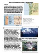
Discuss the environmental impact of a Mount St. Helens tectonic event. Introduction Mount St Helens is an active volcano, south-western Washington in the Cascade Range. The volcano which had been dormant since 1857, began to show signs of renewed activity in early 1980. On May 18 1980, it erupted with such violence that the top of the mountain was blown off and a cloud of ash and gases was sent to an altitude of 19 km (12 mi). The blast killed 57 people and destroyed all life in an area of some 180 sq km (70 sq mi); an even wider area was covered with ash and debris. It continues to emit ash and steam intermittently. As a result of the eruption, the mountain's elevation was decreased from 2,950 m (9,677 ft) to 2,550 m (8,365 ft). A National Volcano Monument was established here in 1982. May 18th 1980 a kryptodome appeared on the north side of the volcano, before this the volcano hadn't erupted for over 120 yrs. March 20th an earth quake happened right underneath the volcano signalling an eruption. Unfortunately Lavafrom the last eruption had acted as a plug, and blocked the volcano. Magma was rising at a rate of six feet a day, casing a bulge on the side of the mountain (Kryptodome). Scientists were using GPS (global Positioning satellites) to monitor the Volcano. March 31st state of emergency announced, 20m exclusion zone was placed around the volcano. May

River Chess Coursework
River Chess Coursework My coursework involve a study of the river chess near Amersham. It is obviously based on the work that we did as part of the Rivers module. My work will show how this river changes as it moves downstream. Firstly, the River Chess springs from the Chess Valley in Chesham and Hertfordshire which is in South-East of England. The reason why we studied R. Chess is because the nearest river to us and it will be wise to take measurements of the size of a small river instead of a large e.g. Thames, where it will be difficult to take measurements. Chess River has a drainage basin of 105 square km that covers parts of Chesham, Buckinghamshire and Hertfordshire. Site 1: 1.5 km from source Site 2: 16km from source Site 3: 17 km From source It is important to study the rivers and systems, so we know what to expect and will be able to control them in different ways Leaves example - where the rivers it will not lead to a disaster to the surrounding villages as we all know that if a major river flood can cause devastation as when the Mississippi flooded in New Orleans in 2005. Therefore studying the history and the rivers we have Aid to bring about the prevention of floods. However, the study of rivers in the summer is different than in the winter because the river depth varies depending more rain in