The Effect of Changing Distance From Toronto's Central Business District on Parking Prices.
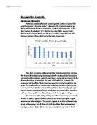
The Effect of Changing Distance From Toronto's Central Business District on Parking Prices Aakash Dheer IB HL Geography Extended Essay Mr. Derek Poon, Advisor 3766 Words Introduction Toronto, Ontario, Canada is one of the most culturally diverse metropolises in the world, with a population of over 4 million people, and a downtown area wielding much of Canada's financial, political, and educational power (United Nations). With many attractive factors, such as business and employment opportunities, entertainment and shopping districts, and the availability of transportation in such a small area, downtown Toronto is quickly becoming very densely populated, with a population of 670,000 people in an area of under 100 square kilometers (Statistics Canada). This population density of over 7000 people per square kilometer will in turn affect demand for housing, services, and parking (Statistics Canada). A fundamental concept of economics is that as demand for a good or service increases, the price of the good or service will increase as well (Parkin). Therefore, in an area with more people living in it, the demand for parking will be higher than a less densely populated area. As a result, the most densely populated area of the city will be the most expensive. In Toronto, this location is the downtown Central Business District (CBD) area, meaning the highest prices for parking

Climate changes in Canada. What consequences derive from the climate change in Canada and what actions are taken part as a result?
Climate changes in Canada: What consequences derive from the climate change in Canada and what actions are taken part as a result? (Essay needs proper foot noting) Table of Contents Abstract............................................................................................2 Introduction.........................................................................................3 I. Impacts due to climate change..........................................4 a) Greenhouse gas emissions b) Arctic Ecosystems c) Fisheries d) Polar bears e) Health Issues II. Changes in regions due to climate change...........10 a) Pacific coast b) Prairie provinces c) Great Lakes-St. Lawrence basin d) Atlantic coast e) The North f) Wetlands g) Permafrost III. Canada's approach on climate change.................15 Conclusion......................................................................................17 Appendix.........................................................................................18 References......................................................................................22 Abstract It is quite evident that climate change is happening around the world. This issue is called global warming. Because of the effect worldwide, Canada is due to be influenced. The increase of greenhouse gas emissions is apparent, as further urbanizations and burning

Geography Field Study - Delineating the CBD Antwerp
Table of Contents Content Page Number ) Introduction 02 2) Aims 03 3) Hypothesis 03 4) Justification of Hypothesis 04 5) Methods of data collection 04 6) Justification for methods of data collection 05 7) Data presentation + Analysis 06 8) Conclusion - Delineating the CBD 21 9) Evaluation 24 0) Bibliography 25 1) Appendix - Raw Data Samples 30 . Introduction: The city of Antwerp is considered to be the capital of commerce and business in Belgium. With a population over 520,000, Antwerp is Belgium's second largest city and is the capital of the Flanders province.1 Apart from downfalls during both world wars, Antwerp continued to experience great economic success, and geographically expanding both horizontally and vertically. My ultimate objective will be to delineate the Central Business District of Antwerp, and we have chosen to study outwards from the Franklin Rooseveltplaats, which we assume to be the CBD of the city. Information along the north, south, east and west transects will be considered. 2. Aims of the field study: I. To delineate the Central Business District (CBD) of Antwerp, Belgium. II. To investigate the extent to which Antwerp's urban morphology conforms to the Burgess' (1924) Concentric Ring Model of the city III. To investigate the distributional pattern and location presence of Antwerp's hotels 3. We hypothesize the

About Iberia Airlines
Capitolul I Prezentarea Companiei .1. Despre Iberia Airlines Iberia este comapania nationala de transport aerian a Spaniei si cea de-a 4 a ca marime din Europa. Desemenea este unul din liderii companiilor aeriene pe rute între Europa si America Latina, avand cele mai multe zboruri. Iberia are o activitate neîntrerupta de 80 ani în industrie si se axeaza în principal pe 3 ramuri: transport de pasageri si bagaje, întretinerea avioanelor si servicii în aeroporturi. Este o companie aeriana privata si listata în indexul Ibex 35 al pietei bursiere din Spania, cu o crestere continua a profitului în ultimii 13 ani, fiind singura din Europa care detine acest record . Deasemenea Iberia este una din singurele comapanii aeriene din lume care a fost inclusa în indexul Dow Jones Stoxx care recunoaste companiile cu cele mai bune practice economice sociale si de mediu. Iberia este deasemenea membru fondator al aliantei Oneworld, alianta care deserveste peste 700 destinatii în jurul lumii si ofera cele mai bune legaturi. .2. Istoric A fost fondata pe 28 iunie 1927 de catre omul de afaceri Horacio Echeberrieta in timpul dictaturii lui Primo de Rivera fiind monopol pe piata transporturilor aeriene spaniole. Nu numai ca a fost prima companie aeriana din Spania, dar a fost si prima companie aeriana care a operat zboruri între Europa si America de Sud, dupa al doilea

Geography - Building a Sustainable House in Australia
SOSE Notes- Zinalume – Sustainable Roofing ZINCALUME steel for Roofing Product Description and Features Roof sheeting made from ZINCALUME® steel is available in a range of profiles. The zinc/aluminium alloy coating on ZINCALUME® steel imparts corrosion resistance of up to four times the life of galvanised steel. Zinculume is the ideal roofing for a eco freiendly house. * Durable and strong * One of the most thermally efficient roofing materials available today * Superior corrosion resistance * Attractive * Available from an extensive network of suppliers * A deterrent against intruders * Excellent resistance to impact from hail * Excellent flexibility in design, can be curved, for truly individual designs * Flexibility of design allows for both traditional straight roof sheeting as well as innovative curved roofing designs * Easy maintenance * Weather tight and secure when installed to manufacturer's specifications. Themal Mass – Rising temperatures: Solution: Thermal Mass. What is it? Thermal mass is the ability of a material to absorb and store heat energy. Materials such as concrete, bricks and tiles have a high density. Using materials that have lightweight such as timber

Food aid: case study
Niger has a population of approximately 13 million inhabitants.Niger was ranked 174 out of 177 countries by UNDP's Human Development Index in 2007. In Niger, 59.5 percent of the population is living below the poverty line. Agriculture is the main source of income in Niger i.e., agriculture is the engine of Niger's weak economy. 82 percent of the population of Niger rely only on farming. The malnutrition rates in Niger are elevated; ten percent of children under five suffer from acute malnutrition and 44 percent of children suffer from chronic malnutrition.Social indicators are also low like the life expectancy at birth is only 44.7 years and the child mortality rate is 20 percent.Thr illitracy rate in Niger is 71% due to the poor school attendance, especially among girls. In 2005, Niger suffered from a severe food security crisis aggravated by drought and locust invasions. With a reduction in food availability and people's ability to purchase what food there was, the crisis resulted in a drastic reduction in household food consumption, distress sales of livestock and other assets and results in rising the levels of acute malnutrition . The current situation in Niger in relation to food supply: Due to the effective partnership between the Government and humanitarian partners, the positive results have been seen in Niger and thecurrent situation offood supply in Niger
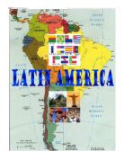
Latin America - history, politics, immigration and literature.
Latin America Spanish and Portuguese colonists and officers, settling in central and south America during the 16th century, are soon followed by the French and English staking a claim to North America. A clear pattern becomes well-known. The two Atlantic seaboard countries of southern Europe concentrate on the southern part of the new continent, while their three European neighbours to the north struggle between themselves to rule north America. The parts of the continent become divided into two distinct parts, which is Latin America and North America. The term Latin America was first used in the 19th century. The region consists with an exception of those parts of the American continent occupied by the Spanish. But the exception is too large to overlook and Brazil belongs to Portugal. Spanish America can not be said. Latin America comes into use at a time when almost all regions south of USA spoke Spanish or Portuguese, which are Latin-based romance languages and are Roman Catholics where in the north of the continent is largely Anglo-Saxon and Protestant ruled. This region was home to many native people and it had superior civilizations, which included the Aztecs and the Inca, before the arrival of Europeans. The Europeans came in the late 15th century. When they came, most of Latin America was owned by Spain and Portugal and some parts were owned by France. In the early

Tourism Case Study
Tourism in Cairo and in the Valley of the Kings by Casey Larson Tourism is a massive industry in which participants can travel all around the globe to see different cultures, such as the tourists seen in picture 1. It can help create a prosperous economy through its direct economic benefits, as well as to destroy a place, taking its Picture 1 irreplaceable culture with it. Tourism, like globalization, can give a country wealth, but can also cause irreplaceable social and cultural damages. The rise of the tourism industry can be traced to the lowering costs of transportation, the big volume of tourists who can afford to travel and have the time, as well as international communications which has allowed a person to have information on different areas of the world and to pick out a place they would like to visit. The improvements of these aspects through better technology, called the process of time-space compression, combined with more peoples' incomes in developing countries increasing, has predictably led to a rise in tourism world wide. This has led to tourism playing an even bigger role in the global economy, and nowhere is this as true as in Egypt. Egypt is a country located in north eastern Africa, with some territory in Asia, as seen in map 1. This is a country of 75 million, in which its main industries include services (51% of work force), agriculture (32%) and

The Problem of Corruption in Egypt
________________ Introduction What is Corruption? * Although there are several conventions dealing with corruption and bribery, there is no single globally accepted definition of corruption and bribery. * Corruption is defined by Transparency International, the leading international organization in fighting corruption, as 'the abuse of entrusted power for personal gain.' * Corruption can also be differentiated in terms of what can be called 'true corrupt intent' and 'necessary corruption', which occurs in order to get things done. Corruption in terms of true corrupt intent implies bribery in order to obtain a service to which one is not legally entitled. In contrast, necessary corruption implies bribery in order to obtain a service to which one is legally entitled. Facilitation payments would fall under this latter category of corruption. * The main forms of corruption are bribery, embezzlement, fraud and extortion, nepotism 1. Bribery : To offer an advantage, whether directly or through intermediaries, to a public official, in order that the official act or refrain from acting in relation to the performance of official duties, in order to obtain or retain business or other improper advantage 1. Embezzlement is the fraudulent appropriation of money or property by a person entrusted to safeguard the assets in another's interests. Embezzlement can be committed by a

Republic of Yemen
Republic of Yemen GEOGRAPHY: -Location: The republic of Yemen is a small country situated in the southern part of the Middle East. It has borders with Saudi Arabia and Oman and has exits to some important seas and gulfs like: Gulf of Aden, Arabian Sea, Red Sea and the straight Bab el Mandeb. Its geographical coordinates are: 15 00 N and 48 00 E. The total land boundaries are 1746 km and its coastline is 1906Km. Total land area is 527.970 square kilometres, all of it being land, none water. It is slightly larger than twice the size of Wyoming and it is slightly bigger than the area of Thailand or Spain. Its current area includes Perim, Socotra, the former Yemen Arab republic (YAR / North Yemen) and People's Democratic Republic of Yemen (South Yemen/ PDRY). -Physical environment: Yemen does not have any permanent river, which means that some rivers appear during the rainy season but do not last after the season ends. Some well known mountains are: The Haraz Mountains, The Sarawat Mountains (located in the western part of the country). The highest peak in the mountains is Jabal an Nabi Shu'ayb (3,760m), which is (Yemen desert) the highest peak on the Arabian Peninsula. Because the mountains have a more welcoming climate, better conditions and a higher rainfall, there is a higher density of population and agricultural activity than in the rest of the country. (Yemen