Study the river Cray and see whether the river actually follows a natural path of a conventional river which is in a text book.
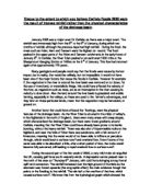
Geography Coursework As part of my GCSE coursework I aim to study the river Cray and see whether the river actually follows a natural path of a conventional river which is in a text book. The river Cray is situated in the south east of London, the source of the river is at a place called St. Mary's Cray. The mid-section is found near a small town called Chislehurst; the river then passes through Sidcup and Dartford. After this it then reaches the mouth which is found at Barnes Cray. The river Cray is actually a tributary of the River Thames; this is when a small river stream joins a main river. My hypothesis is that the river Cray does not the conventions of a text book river. I believe my predictions to be true because of what I have seen from pictures of the river Cray it has been largely influence by humans by this I mean that the rivers natural course has been changed by road being created, shop and houses being built, etc. The only way to find out if my predictions are correct is to first find out how a conventional river looks like and what some of the characteristics of a conventional river are, then I will travel to the river Cray and carry out some tests. When this has been done I can compare both rivers accurately and make my results. The main part of this introduction looks at what you would expect a natural river to look like. The information I have has been

Analyse How the Inputs and Outputs from a River Basin Can Vary Over Time
Analyse How the Inputs and Outputs from a River Basin Can Vary Over Time Both the inputs to and outputs from a river basin can vary both spatially (in different areas) and temporally (over time), due to daily, seasonal and annual occurrences. Precipitation mainly reaches the grounds surface from the atmosphere as snow and rain. Heavy snow is often intercepted and stored on the tops of hills and mountains and may lead to a decrease in river levels. Some rainfall may fall directly into the stream or river and some may fall onto the land and flow into the river basin through a variety of routes including throughflow, stemflow and overland flow. The intensity and duration of precipitation has a short term but regular effect upon both the inputs and outputs of a river basin due to the weather patterns. Over a short period of time, for example a week, the precipitation levels over the river basin can significantly vary, as on some days of the week the total precipitation can be extremely high and the next it could be virtually zero. Long periods of rainfall are the main cause of flooding as the soil has become saturated it reaches its infiltration capacity and infiltration is reduced, therefore increasing the frequency of surface run off and the risk of flooding. In addition to the weather having a large impact on the inputs over a short period of time in and around the

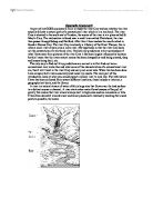
A corrie on Ben Lui in Scotland
Upland Glacial Features Corrie In geography, a corrie is a terrain feature created by glaciation in high mountains. The word is an Anglicisation of the Gaelic word coire meaning hollow. It is known in Welsh as a cwm (often Anglicized as coomb, or coombe), and the French word cirque is used to denote a very similar geographical feature. Corries begin as small hollows on a relatively smooth slope. During the ice ages, snow and ice would gather in these hollows, eroding the floor and walls of the hollow, causing them to get larger and deeper. As the hollows grew, so would it gather more snow and ice which would compact into a small glacier. Eventually, the newly formed glacier cut through the lowest edge of the hollow and continue down the hillside. A corrie on Ben Lui in Scotland U shaped valley or glacial trough They are generally found in glaciated uplands. They are characteristically steep-sided and flat-floored. Over-deepening of glacial troughs causes tributary valleys to hang above the main valley. Spurs are truncated, and the head of the valley often ends abruptly in a steep rock wall or trough head, for example the Lauterbrunnen Valley, Switzerland. Glacial troughs are occupied by small valley glaciers in high mountain ranges such as the Alps and Himalayas today. However, it is unlikely that these glaciers were responsible for excavating glacial troughs. Most were
River Studies
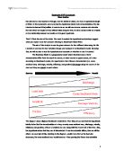
Geography MYP Coursework River Studies Rio Lizandro is a river located in Portugal, near the district of Lisbon, and has an approximate length of 30km. In this coursework, we have to test the hypothesis related to the characteristics of the Rio Lizandro to discover if it is justified. In order to do so, we will have to draw, measure and calculate the data which we are give on four different sites along the river, and thus conclude with an analysis on the relationship between our results and the given hypothesis. Task 2: State the aim of the study. You need to explain the hypothesis and perhaps suggest what you expect to be the outcome referring to Bradshaw's Model River. The aim of this study is to use the given data on the four different sites along the Rio Lizandro to see how its river variables change and compare it to Bradshaw's model. By doing this, we will be able to test the hypothesis and conclude on whether or not it is correct. The Bradshaw Model is a geographical model which illustrates how a river's characteristics differ from the mouth to source, or lower course to upper course, of a river. According to Bradshaw's model, the hypothesis is that "Stream characteristics (i.e. cross-sectional area, discharge, velocity, efficiency, and gradient) all change along the course of the river and they are related to each other". Source

A study of the downstream changes in the Curly Burn River
A study of the downstream changes in the Curly Burn River Aims: The aim for this field work is to investigate the downstream changes in the Curly Burn River in Limavady. Several hypotheses I decided to investigate included the increase of both channel width and depth with increasing distance downstream, the increase in velocity and discharge with increasing distance downstream, the decrease in slope downstream and the decrease in the calibre of bedload particles with increasing distance downstream. Planning: The Curly Burn River was chosen for us to investigate due to the various aspects it had relevant to our AS study of fluvial environments. The primary data I collected in the field included measurements such as the width and depth of the river as well as the float velocity, discharge, slope and bedload shape and calibre. For a secondary data source I used an ordnance survey map of the Limavady catchment area (1:50,000) to measure the distance between sites on the river as well as locate any nearby features that may be useful. I also used Power's roundness index to identify the shape of bedload particles. The sampling method I used was a combination of pragmatic systematic sampling to locate suitable sites of equal distance along the river and random sampling to choose various bedload particles. These methods of sampling proved to be efficient in obtaining an accurate
Global warming effect on Ice and Snow resources
Global warming effect on Ice and Snow resources This essay is to look at snow and ice resources around the world and to understand the effect global warming will have them By looking at what snow and ice is used for it will enable me to conclude how much global warming is becoming a problem to natural resources and populations around the world. Global warming,Is the warming of the Earth by means of green house gases. Green houses gases such as Methane; Carbon dioxide and water vapour get trapped in the ozone layer and break it down. This is due to the chemical reactions that occur when these gases combine with the ozone (O3) Ice and snow is used as a major resource it provides four main resources to a population. Glaciers are the main source of ice and are not just a different landform but an attraction of tourists to an area. Glaciers now a day are seen to be a natural resource like coal was in the 1950's some thing to be harnessed by growing populations. They are used in the following ways - As a source of drinking water People living in countries such as Bolivia rely on ice melt from nearby ice caps to provide water during dry seasons - To produce hydroelectric power Damming melt water for glacier's to provide high energy and wave levels to generate electricity through hydroelectric means - Snow and Ice bring tourists to an area. Polar bears nature and
Geography Fieldwork Write-up
Geography Fieldwork Write-up Analysis Size of the Channel - the channel width grew larger the further downstream you were. This is shown on the diagrams of cross sections of the channel at 3 different points in the river. This is because of the higher discharge in the lower course of the river due to tributaries adding more water to the main river, therefore the river widens to be able to transport this extra water. Relationship between Velocity and Discharge - The Spearman Rank Correlation Co-efficient suggested a strong positive relationship between velocity and discharge. In other words, the higher the velocity of the river, the higher the discharge of the river. Roundness of the Load - the further down the river, the rounder the load was. This is because the further a rock has been in the river and has travelled in the river, the more erosion processes, such as abrasion and attrition, and transportation processes, such as saltation and traction, it will have been exposed. These processes will have gradually eroded the angular parts of the rock until eventually the rock is left roughly rounded. However there were notable anomalies to this theory, such as a rock which was picked up at survey site 10 (a site in the middle course of the river), being the most angular rock, measuring 50 on the R.I. scale (measured by Roundness Index) found in all parts of the river. You

Examine the factors influencing the movement of glaciers.
Examine the factors influencing the movement of glaciers. Glacier is defined as, 'a mass or river of ice moving very slowly'. Glaciers range in size considerably, Antarctica being the largest ice mass at 12.5 million km and a smaller ice mass of 12km existing in Africa. Glaciers move due to the force of gravity from areas of high altitude to lower areas. There are different mechanisms of glacial movement depending on the type of glacier. Cold (polar) glaciers are frozen to the underlying rock surface. These are found in high-latitude locations where the relief is low and basal temperatures are below the pressure melting point. Cold glaciers have very slow rates of movement, e.g. The Meserve glacier in Antarctica moves only 3-4 metres per year. Warm (temperate) glaciers on the other hand are not frozen to their bed. This type of glacier is found in high-altitude locations where the relief is steep and basal temperatures are at or near the pressure melting point. Temperate glaciers move very rapidly, e.g. The Franz Josef glacier in New Zealand moves approximately 300m per year. It is the basal temperature that determines the mechanism of movement. In what follows I will explain the factors influencing different mechanisms of movement. Temperate glaciers move mainly by basal sliding. If the basal temperature is at or above pressure melting point, a thin layer of meltwater

Describe and explain how the processes operating in permafrost result in landforms specific to periglacial areas.
Describe and explain how the processes operating in permafrost result in landforms specific to periglacial areas. Periglacial areas are found on the edge of glaciers and are characterised by permafrost, freeze thaw action. Summer temperatures rise above freezing point so ice melts. Three types of periglacial regions can be identified these include the Arctic continental, Alpine and Arctic maritime. Periglacial landforms and processes can be classified into five classes, Ground ice, Frost weathering, snow, meltwater and wind. Ground ice involves three processes including ice crystals and lenses (frost heave), ground contractions and freezing of ground water from these processes sorted stone polygons, ice wedges with unsorted polygons and pingos are formed. Frost heave includes several processes, which cause either fine-grained soils such as silt and clays to form small domes or individual stones within the soil to be moved to the surface. It results from the direct formation of ice - either as crystals or as lenses. The thermal conductivity of stone is greater than that of soil this results in the direct formation of ice, the area under a stone becomes colder then the surrounding area and ice crystals form. Further expansion by the ice widens the capillaries in the soil, allowing more moisture to rise and freeze. The crystals, or the larger ice lenses which form at a

The characteristics of the Horsbere Brook vary along it length.
The characteristics of the Horsbere Brook vary along it length. Introduction We followed the Horsbere Brook from its source in Buckholt Woods) to its confluence with the River Severn. We went to six places. They are Birdlip, Brockworth, Buckholt Woods, Innsworth, Hucclecote and Sandhurst. All these places are in the Cotswold Hills. The Cotswold Hills is made up of limestone, clay, chalk, sand and clays. As I work through my coursework, I will try and answer the following questions below and I will also think about them as I go along my coursework. ) Does the depth of the River change from source to confluence? 2) Does the width of the River change from source to confluence? 3) Does the velocity of the River change from source to confluence? 4) Does the bedload of the River become smaller in size from the source to confluence? Picture of Meander: (Meander spotted at site ) Meander - When rivers flow over a flatter land, they develop large bends called meanders. As a river goes around a bend most of the water is pushed towards the outside causing increased erosion. Attrition - Material is moved along the bed of a river, it collides with other materials and breaks up into smaller pieces. Corrasion - Fine material rubs against the river bank. The bank is worn away by a sand-papering action called abrasion and collapses. Hydraulic action - The sheer force of the