Soil Erosion.
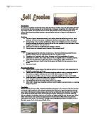
Introduction: Soil erosion is a gradual process that occurs when the actions of water, wind, and other factors eat away and wear down the land, causing the soil to deteriorate or disappear completely. Soil deterioration and low quality of water due to erosion and run off has often become a severe problem around South Africa. Many times the problems become so severe that the land can no longer be cultivated and is abandoned. Problems: > The loss of topsoil reduces the country's soil fertility, hence the ability to grow food. More fertilizers will have to be used as a substitute for the lost soil, therefore a raise in food costs. > The hydrology of river systems is affected, as there is less infiltration and more runoff and therefore reducing the amount of water in the soil for new vegetation to use next season. Seeds struggle to germinate in bare exposed soil. > Dams become silted up and there storage capacity is reduced. > Floods become an increased hazard, because of the increased runoff. Causes: > Overgrazing causes the destruction of plant cover, which would otherwise protect the soil; therefore instead of the rain soaking through the soil, it washes it away. > Ploughing of soil vertically with a slope, increases runoff and accelerates soil erosion. > Destruction of forests is also a major cause, as well as footpaths used for domestic purposes, which turn into
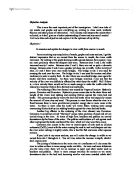
To examine and explain the changes in river width from source to mouth.
Objective Analysis This is now the most important part of the investigation. I shall now take all my results and graphs and sum everything up, relating to class work, textbook theories and other pieces of information. I will analyse and interpret the results that I collected, as it shall give me a better understanding of rivers and my overall results! I will now take each objective and explain it to the optimum of my ability. Objective 1 To examine and explain the changes in river width from source to mouth. From examining my compilation of results, graphs and cross sections, I get the distinct impression that as we moved from the source to mouth, the rivers width increased. By looking at the graph showing width against distance from source, I can see more precisely, where the steepest rises were. Between sites 1 and 2, the width increased nearly 1 meter. Between sites 2 and 3, there was not as quite a dramatic change. Between sites 3 and 4 was a gradual yet steep rise in width. In the vicinity of sites, 2,3 and 4 there were man made bridges. The bridge at site 2 was used for crossing the road over the river. The bridge at site 3 was used for tractors and other machinery to enter a nearby field. At site 4 there was an arched bridge, once again for tractor and farm machinery. As there were bridges involved, I can say that the velocity of the river was definitely

Erosional Landforms on the Dorset Coastline
Erosional Landforms on the Dorset Coastline Introduction In this leaflet I am going to present my findings about different types of erosion, and at how they take effect different locations. The relevant locations that I have studied are part of the Dorset coastline. These are: . Lulworth cove, a bay created through millions of years of erosion. 2. Stairhole, a deep cleft that represents stage 1 of the evolution of the coastline. 3. Durdle door, an arch that will soon collapse and erode away. Types of Erosion Erosion is the gradual wearing away of land by water, wind and general weather conditions. The amount of erosion depends on the power of the waves and the rock type. The amount of energy acquired by waves depends upon the wind velocity, the duration of the wind and the distance over which the waves have traveled. This is known as the fetch. There are two types of erosion that can occur at the coast, these are: . Sub-aerial processes (cliff face processes)- These are erosional processes that take place above sea level, affecting the parts of the coastal zone that are not directly influenced by the sea. The processes included in sub-aerial erosion are: * Freeze-thaw * Salt crystallization * Chemical weathering * Biological weathering * Human Activity * Mass movement 2. Marine processes (cliff base processes)- These are erosional processes that occur when
Rain by Somerset Maugham - Comment on the significance of the recurrent image of rain in this short story.
English Rain: Somerset Maugham. Task: Comment on the significance of the recurrent image of rain in this short story. Rain, by Somerset Maugham seems to have a rather irrelevant title when first looked at. The first part of the story that introduces us to the story have no relevance to rain, or any other weather feature for that matter. However, as the story progresses, rain, and metaphors about the weather play a very important part in the story, and it sets the mood of the story. We do not get an image of the weather until page 8 (page numbers from collected short stories vol.1). However when the rain is introduced it happens very quickly and it moves the story on. 'But Mrs Davidson had given two or three of her birdlike glances at heavy grey clouds that came floating over the mouth of the harbour. A few drops began to fall. "We'd better take shelter," she said. They made their way with all the crowd to a great shed of corrugated iron, and the rain began to fall in torrents.' This quote shows how immediate the rain came. It seems to the reader that as soon as they have shelter, the rain falls intensely. It is also interesting here, because it seems that they have only been on the island for a few minutes, but yet then, the rain starts. The reader gets an impression of nature versus the English-men. We get the impression that nature is fighting the white men and
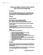
My aim is to investigate, using the Curley Burn River, a 4th order tributary of the River Roe drainage basin, the relationship between the changes in the river and the distance down stream. I will formulate 3 hypotheses around the river model
Downstream changes in hydraulic Geometry and bed load in the River Roe drainage basin Introduction: My aim is to investigate, using the Curley Burn River, a 4th order tributary of the River Roe drainage basin, the relationship between the changes in the river and the distance down stream. I will formulate 3 hypotheses around the river model. Planning: Hypothesis formulated: Hyp 1 -velocity will increase with distance downstream Hyp 2 -discharge will increase with distance downstream Hyp 3 - Bed load size and shape will decrease with distance down stream We worked on the River Roe and Curly Burn with the help and use of Magilligan field centre because: The centre had trained people in field work; they could provide all the proper equipment and insurance. Access permission, risk assessment and pilot study were already done by the centre Safety: Precautions taken before entering the field: * Appropriate water proof clothing had to be worn e.g. waders * A spare set of clothing had to be brought * There had to be risk assessments of the sites we were visiting * Buoyancy aid and hard hat had to be worn at all times * Open cuts had to be cover before going to the river to prevent Weil's disease * There had to be the safe use of equipment * An emergency plan had to be made and someone else not going to the field must have known where we were * A mobile phone
Dovedale on The River Dove.
Dovedale The River Dove rises on the eastern side of Axe Edge and flows almost southwards to the boundary of the Peak, forming the boundary between Derbyshire and Staffordshire for the whole of its length. The river is renowned as one of the most beautiful in the area, if not in the country, and is a famous trout-fishing river, immortalised by Izaak Walton in his book 'The Compleat Angler' - written when visiting his friend Charles Cotton at Beresford Hall near Hartington. Axe Edge is a high gritstone moor, and the river plunges steeply down to arrive at the limestone rock near Hollinsclough. Around it the hills rear up around it in weird shapes as they are the remains of ancient coral reefs. The Dove flows on through the tiny hamlet of Crowdecote and past Pilsbury and Sheen to reach Hartington and begin the section which has made it famous. Below Hartington is Beresford Dale, where the river enters the narrow gorge where Walton and Cotton fished. This is the most intimate stretch of the Dove, with the river hemmed in by steep cliffs and heavily wooded slopes which tower over it, while the stream glides lazily through turbid pools. At the two cliffs known as the Celestial Twins you enter Wolfscote Dale, which continues down to Lode Mill, about four kilometres distant. All the way you are in a fine deep valley, often flanked by steep cliffs and accompanied always by the
At what points in this novel do you feel its author is breaking out of realist modes of story telling into the realms of fantasy?
At what points in this novel do you feel its author is breaking out of realist modes of story telling into the realms of fantasy? It is these bursts of fantasy, mentioned in the title, which Carter injects into her work of fiction 'Wise Children' that makes this novel the perfect example of the carnivalesque. This term accounts for the surrealism of the novel which moves away from the tragedies of Dora's tale, celebrating the lighter side of life. According to Daphne Moor, the main features of the carnivalesque include intertextuality, 'the levelling or inversions of hierarchies,' 'revelry and celebration', 'the chaos of change and of fluctuation', 'laughter that regenerates even as it reduces', and finally the 'acknowledgement of the body and its cycles of birth, aging and death as well as the organic functions of eating'. All of these factors are applicable to 'Wise Children'. Although there are elements throughout the first chapter, one of the best examples of the carnivalesque here is when Carter first introduces us to Perry. He is in fact portrayed by Carter in this way as she does not trap him in Dora's dialogic, polyphonic narration, but also allows him to have a magical, spontaneous quality about him so that pandemonium seems to follow him through each page. He himself is portrayed as a travelling carnival. These qualities are evident throughout his life as he

Bodiam Castle.
Bodiam castle was built between 1585 -88 in east Sussex by Sir Edward Dalyngrige. There is still a mystery on why Bodiam castle was built; many historians still don't know exactly why Bodiam castle was built. Some historians say Bodiam castle was built as a defensive feature against a possible French inversion, some say it was built as a rich old soldier's dream house or a luxurious rich mans hotel. I agree with both historians who think this way. In this essay I going to consider both reasons on what historians think Bodiam castle was built. Firstly I will consider whether Bodiam castle was built as a defensive feature against a possible French inversion. I agree with historians who think this that Bodiam castle was built as a defensive feature against a possible French invasion because of the following reasons: HUNDRED YEARS WAR The hundred years war between the French and the English was not going as planed for the English. King Richard II had lost most of his conquered land in France and several ports along the coast where been attacked and burnt by the French. This became much of a threat especially when the French attacked and temporally occupied Isle Island. The writer of the "English castles" (source B ) thinks the hundred years war was and the attacking of islands by the French was one of the reasons why Bodiam castle was built, he says; Raiders pillaged and burnt

The Afon Glaslyn, SnowdoniaCase Study of fluvial landforms and processes
The Afon Glaslyn, Snowdonia Case Study of fluvial landforms and processes All rivers aim to reach equilibrium so they are balanced and when they are in equilibrium from source to mouth a smooth curve is created called the graded long profile. However, as you can see from the diagram many rivers such as The Afon Glaslyn, do not acheive equilibrium and reach their graded long profile: Long Profile of Afon Glaslyn River with graded long profile Rivers become out of equilibrium when there is a change in base (sea) level. There can either be a positive change (rise) in the sea level or a negative change (fall) in sea level, resulting to a change in base level and a new graded long profile. Sea level changes happen because the Earth is in or out of glacial periods. Therefore sea level is changed either eustatically- a change in sea level due to a change in the amount of water locked up in ice sheets, or isostatically- when the the change in sea level is due to a change in the level of land caused by growing or retreating ice sheets. The change in base level affects the long profile of a river and as the river tries to reach its new graded profile in order to reach equilibrium there are various processes and landforms found along the river's course. By looking at The Afon Glaslyn we can see how and why these processes occur and landforms
Energy tranfers within the atmosphere
Energy transfers in the atmosphere The source of energy for our planet is the sun. The sun's energy moves through space, and then through the earth's atmosphere and then finally reaches the earth's surface. This energy is then absorbed by the earth's surface and is then re-radiated as heat energy. There are three ways that heat energy is transferred through the atmosphere, radiation, conduction and convection. Conduction happens near the ground as heat energy is passed on through the movement of heat particles. All heat energy travels from a warmer region to a cold region, therefore the rate of conduction depends on factors such as temperature, surface area and the given levels of conductivity for various substances. The conduction of heat energy through the atmosphere is intensified by the amount of heat energy, which is radiated by the sun to be absorbed by the earth's surface. The transaction of heat energy from the sun to the earth is known as radiation. This is how the earth receives the heat energy emitted from the sun. This radiant heat energy is also absorbed by the earth's surface, this is what provides us with an average surface temperature of 14/15 degrees C. The heat energy absorbed by the earth's surface fluctuates in certain regions of the atmosphere due to various factors i.e. clouds absorbing heat, the sun's orbital path and the


