
An earthquake is a sudden and sometimes catastrophic movement of a part of the Earth's crust.
An earthquake is a sudden and sometimes catastrophic movement of a part of the Earth's crust. Earthquakes result from the dynamic release of elastic strain energy that radiates seismic waves. Earthquakes typically result from the movement of faults, planar zones of deformation within the Earth's upper crust. The word earthquake is also widely used to indicate the source region itself. The Earth's lithosphere is a patch work of plates in slow but constant motion Earthquakes occur where the stress resulting from the differential motion of these plates exceeds the strength of the crust. The highest stress (and possible weakest zones) is most often found at the boundaries of the tectonic plates and hence these locations are where the majority of earthquakes occur. Events located at plate boundaries are called interplate earthquakes; the less frequent events that occur in the interior of the lithospheric plates are called intraplate earthquakes Earthquakes related to plate tectonics are called tectonic earthquakes. Most earthquakes are tectonic, but they also occur in volcanic regions and as the result of a number of anthropogenic sources, such as reservoir induced seismicity, mining and the removal or injection of fluids into the crust. Seismic waves including some strong enough to be felt by humans can also be caused by explosions (chemical or nuclear), landslides, and collapse
As the water flow progresses downstream, the river channel should become wider and deeper due to lateral and vertical erosion
Hypotheses I am testing that this is how the following hypotheses will change as you progress downstream: * The river will get wider and deeper * The velocity will increase * The discharge will increase * The gradient will decrease I will also test the following hypothesis: * Sediment size will decrease Predictions As the water flow progresses downstream, the river channel should become wider and deeper due to lateral and vertical erosion. This is because more tributes add to the water flow as you get further downstream therefore the velocity of the river increases. The speed of the water rushing past causes lateral erosion in the river banks and vertical erosion in the river bed - making the river both wider and deeper. The rivers discharge will also increase because of the rivers tributaries contributing to the water flow of the main river. These tributaries help collect water from inside the river basin and carry it to the main river where it joins at a confluence. The gradient of the river will decrease as the water flows further down the river. This is because the gradient is very steep in the Upper Course as the Source is always the highest point. As the water flows down hill from the Source; it cuts down to sea level under gravity before becoming very slow moving when it reaches the mouth to be discharged into the sea or into another river. The size of

kobe earthquake
Question Two: Why did the Kobe Earthquake in 1995, do so much damage and kill so may people? The earth's surface is not all one big piece. It is broke down into several different pieces called plates. Each plate moves a few centimetres a year. The place were two plates join up we call a plate boundary. Major earthquakes and volcanoes eruptions take place at these plate boundaries. Japan is at the boundary of three plates. It is located were the pacific and the Philippians plates move towards the Eurasian plate. As the two plates meet the Eurasian plate they are forced downwards and under the Eurasian plate. The movement has resulted in lots of earthquakes and volcanoes all over the country killing many people and destroying much land and crops. The effects of the Kobe earthquake were of awful devastation. 5,000 people died in the earthquake and 350,000 were made homeless. This was an effect of the earthquake. But also gas pipes exploded and fires burnt all over the city, this was a secondary cause of death caused by the earthquake. Other secondary causes of death were underground water pipes burst all over the city. Large areas of Kobe were blacked because electricity lines were cut. With the smoke from the fires the search for survivors was difficult. Several hospitals in the old part of Kobe were destroyed in the earthquake. When the ground moved some of the buildings did

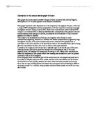
Volcanic Eruptions : Monserrat
Location of Monserrat and volcano Part of a string of islands created by volcanic eruptions, Monserrat is located in the Caribbean Sea, southwest of Puerto Rico. Source: http://www.factmonster.com/atlas/country/montserrat.html Facts about Monserrat Area- 38 sq. miles Population- 11,000 Capital- Plymouth Language/s- English Ethnic groups- Black, White Religions- Protestant, Roman Catholic Highest point- Chance's Peak 3,002ft (915 m) Climate- Tropical, little daily or seasonal temperature variation. Exports- Plastic bags, hot peepers, cattle, live plants Imports- Fuels, manufactured goods, lubricants Natural Hazards- Severe hurricanes (June to November); volcanic eruptions (full scale eruptions of the Soufriere Hills volcano occurred during 1996-97). Eruptions and what happened July 1995 After 350 years of non-activity, Chances peak erupts. This is the first historical eruption. August 1995 Two-thirds of the population are evacuated to the north of the island, which is now the only safe point. April 1996 Monserrat's capital Plymouth is evacuated. June/July 1997 Due to pyroclastic flows, valleys and forests are covered in ash or lava and many buildings are destroyed by fire. Over half the island's population leave Monserrat for the neighbouring island, Antigua, or countries such as the U.S.A or the U.K. Soufriere Hill exploding Source:

Coastal processes - revision notes
What are coasts? * Unique interface between land and sea * The narrow zone where land and sea directly interact * Dynamic ever changing environment * 50-60% of the world's population live on coastal plains, refer to world map and the major cities. The coastal systems is an example of an open system in that it has inputs from outside like river sediment, and outputs into other systems like sediment transported into deep sea's. Importance of coasts to humans include many factors such as premium economic industry sites for industry and marine trade, water for cooling systems or for delivery of bulk items brought from over sea's, habitats such as ecosystems, coastal natural protection from sloped beaches, defensive sites for human/ residential development. What is a shoreline management plan? 'A document which sets out a strategy for coastal defence for a specified length of coast taking account of natural coastal processes and human and other environmental influences and needs' This is used to divide up the coast and take in consideration of the problems occurring in each individual sediment cell, there are 11 sectors, which need to be cared for with things such as: * Natural coastal processes * Coastal defence needs * Environmental considerations * Planning issues * Current and future land use * Sub-Cell boundary ---- Major Cell boundary Fetch = Distance
If bed load size decreases downstream with distance downstream.
Avery Hill GCSE Unit 2: Water, Landforms And People Introduction (draft) The main idea of my investigation is to study if bed load size decreases downstream with distance downstream. I will be studying 3 areas of the River Usk. The River Usk is 5.5 km long but my investigation will only study 2km of the river. The river begins with many meanders but further downstream it straightens out and then meanders again. On the edge of the river side the land had been eroded (undercutting) and the land was soft clay. The weather on the day of study was sunny with a slight breeze. There was some vision of human activity in the drainage basin; there were quad bike skid marks and farmers. If the river basin is used for investigation as the discharge level can be studied better as we could enlighten whether discharge was more or less nearer tributaries. Discharge is the amount of water, which is added from tributaries, which makes the water energy faster. Further downstream more sources (tributaries) will add to the river. The river will get faster and attrition will occur which causes the bed load to become smaller and rounder. The largest size a river can carry is competence. The largest quantity is capacity. Upstream there are larger rocks but as discharge rises rocks decrease in size further downstream. I believe that the discharge is slowed down due to many rocks being
Description of the annual rainfall graph for Kano, Nigeria
Description of the annual rainfall graph for Kano This graph shows the annual weather change in Kano located in the north of Nigeria, West Africa at 12° N of the equator in the tropical continental. This graph illustrates small fluctuations in the temperature throughout the year, with only a range of 8°C (change from January to December), with the temperature staying very high throughout the year with as lows as 26°C. Peak time in the summer reach towards 35°C in April to as lows as 25°C in January and December. Illustrated on the graph are the wet and dry seasons each lasting six months, dry seasons from November to April and wet seasons from May to October. This is due to the concentration of the sun, as in equator were the sun is more concentrated outputting 1kw/m2 at a constant rate means temperatures are generally high throughout the year, with cooler seasons and warmer seasons (view graph).Also to contribute to the warm weather is the dark forest areas in the closed savanna, due to being dark the trees absorb the heat, this is not as likely in the open savannas. Located in the tropics means the sun has a reduced angle in the sky for part of the year, meaning the sun light has to penetrate through more atmospheres, and in the rainy seasons cloud, this reduces the temperature as energy is lost. Many other contributions affect the temperature, that clouds reflect

Continental Glaciation
Continental Glaciation Drumlin - A smooth, oval, low hill or mound of sand and gravel - Steep side facing glacier - smooth end facing in direction of glacial movement Crag and Tail - A hill showing a precipitous face on one side and a long gentle slope or tail on the other - Hard rock protecting loose material, so it is not swept away by the ice Roche Moutonne - small mound of hard rock - w/ smooth striated (facing glacier) - due to abrasion and steeper and rougher downside (due to plucking) Esker - long continuous, steep sided ridge which is the raised river bed that flows underneath a glacier - created when discharges are low enough for fluvial deposition Kames - ridge or mound of poorly sorted water- laid materials (glacial sands and gravels) associated with formal continental ice fronts Kame Terrace - a terrace formed of sand + gravel deposits by a stream of melted water between a glacier and its trough - When the ice melts and the terrace is left above the rest of the valley floor Kettle Lakes - When a glacier retreats it leaves behind large chunks of ice which become embedded in the ground and are insulated - When they melt small ponds or lakes form Outwash Plain - are just in front of the glacial stout which is characterized by braded streams because the sediment supply is too great for the available steam and channel slope
Osaka Kobe Earthquake
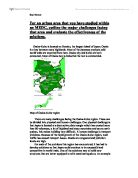
For an urban area that you have studied within an MEDC, outline the major challenges facing that area and evaluate the effectiveness of the solutions. Osaka-Kobe is located on Honshu, the largest island of Japan. Osaka is a bay between steep highlands. Most of the Japanese products sold world wide are exported from here. Osaka city and Kobe are both connected, Most of Osaka bay is industrial the rest is commercial. Map of Osaka-Kobe region There are many challenges facing the Osaka-Kobe region. These can be divided into physical and human challenges. One physical challenge is that Japan is located at a destructive plate margin which has created more than 80 volcanoes, a lot of highland and steep mountains and cause earth quakes, this makes building very difficult. A human challenge is transport problems. Because of the rapid growth of the Osaka-Kobe region, road traffic has caused transport issues. Roads are congested and pollution levels are high. For each of the problems this region has encountered, it has had to develop solutions so that Japan could continue to be successful and competitive in world trade. One of the solutions was to build new structures that are better equipped to with stand earthquakes. An example of this is the Akashi Bridge, its foundations are buried deep under the sea bed to resist earth quakes, and the foundation supports have been

Holderness Coast .
Holderness Coast. Holderness is the number one place in Europe for coastal erosion with 7 to 10 metres of land being eroded each year and 29 villages have already been lost. The main factor for this erosion is that the cliffs are made out of clay and are soft rock this allows water and air to get into cracks in the rock and make the cliff unstable. The village of Mapleton looked like being the 30th village to be lost due to erosion. Mapleton: Mapleton was almost lost by erosion but was saved by a coastal protection scheme. The main reason for this was that the B1242 was running strait through the village and was in danger of being lost. It needed to be protected because it would be very expensive to build the road somewhere else. £2 million was spent on coastal protection by putting granite blocks and groynes in place. However this had disastrous consequences further down the coast because the groynes deprived the beaches of sediment so the beaches became smaller and didn't protect the cliffs from wave action as well as they used to. Flamborough Head: The cliffs at Flamborough Head are some of the highest in England are made of chalk which is very strong. The bottom of the cliffs have lots of caves because they are exposed to wave erosion at low tide. The erosion is concentrated along the weak points of the cliff forming cave, arches and eventually stacks like the


