Mount Sakurajima volcano report.
By Joseph Hemingway Location: Kyushu, Japan Height: 3,665ft Type: Stratovolcano - also called a composite volcano, is a tall, conical volcano composed of many layers of hardened lava, tephra, and volcanic ash. Last Eruption: 2007 914 * The 1914 eruption has been the most powerful in the Japanese twentieth century. * During the eruption lava flows filled in the narrow strait between the island and the mainland, converting it into a peninsula. * Before 1914, the volcano had been dormant for over a century. * The eruption began on 11 January 1914. * Almost all residents had left the island in the previous days, in response to several large earthquakes which warned them that an eruption was imminent. * Initially, the eruption had been very explosive, generating eruption columns and pyroclastic flows, but after a very large earthquake on 13 January 1914 which killed 35 people, it became effusive, generating a large lava flow. * Lava flows are rare in Japan-the high but the lava flows at Sakurajima continued for months. * The island grew, engulfing several smaller islands nearby, and eventually becoming connected to the mainland by a narrow isthmus. Recent Activity * The volcano resumed activity in 1955, and has been erupting almost constantly ever since. * Thousands of small explosions occur each year, throwing ash to heights of up to a few kilometers above the

How has the development of the rainforest led to conflict between different groups of people?
How has the development of the rainforest led to conflict between different groups of people? The rainforest is a tall dense jungle. The climate of the rainforest is very hot and humid so all animals and plants living there have adapted to these conditions. The reason that it is called a rainforest is because of the high amount of rainfall that it has each year. The rainforest covers on 6% of the earth's surface but contains over half the species of the plant and animal species. The rainforest can be found in: Central America: it used to be totally covered in rainforest but is now less because large areas have been cut down for cattle ranchers and sugar plantations. The Amazon: The Amazon is the world's largest tropical rainforest. It Even has the worlds second longest river (the Amazon) running through it. The Amazon is home to the greatest variety of plants and animals on Earth. A 1/5 of the entire world's plants and birds and about 1/5 of all mammal species are found there. This has been cut down due to logging mainly. Africa: This is where the world's second largest rain forest is. Madagascar is one of the main places for the rainforest and contains unique plants and animals but now many of them have gone. Southern Asia: From the east to the west is covered in rainforest including Bangladesh which has the largest area of mangrove forest. Australasia: This forest
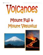
Volcanoes - Comparing Mount Fuji and Vesuvius
Volcanoes Location Page 1 Why did they erupt? Page 2 Human Impact Page 3 Physical Impact Page 4 Similarities & Differences Page 5 Conclusion Page 6 Bibliography Page 7 The volcano, Fuji, is found on the southern Honshu Island in Japan. It is the largest and most popular volcano in Japan, rising to 12,388 feet (3,776 m) above sea level and has a perimeter base of 50km. Fuji is a typical cone shaped volcano and has kept its shape for around 5,000 years. Fuji consists of three different volcanoes called Komitake, Ko-Fuji and Fuji which lie one upon the other. Mount Vesuvius is a volcano in the east of Naples in Italy. The volcano is over 17 000 years old and is still at this moment, active. It is only 4190 feet tall (1277 m) with a base of 48km (3 miles) but its past eruptions have been very dangerous, killing a vast amount. So far Vesuvius has had 50 eruptions and in only one of these eruptions, it has killed over 3 000 people. The volcano is moderately young but has erupted several times and most of these eruptions have been somewhat large in size, but overall, Fuji has had 2 mainly damaging eruptions. Any volcanic eruption is normally caused by plate boundaries. Mount Fuji is an island-arc volcano which means that three

The CBD of Bangor
The CBD of Bangor This is a project based on how Bangor changes as you move towards or away from the centre of the town. To investigate this as a group we have formed four questions; we will answer these with evidence and explain the method in which we obtained the results. Using this evidence I will compare and analyse to delimit the CBD (Central Business District) of Bangor. The Four Hypotheses: . Is there a district change in functions at the edge of the CBD? 2. Do building heights increase towards the centre of the CBD? 3. Are rateable values highest at the centre of the town? 4. Do pedestrian counts decrease from the centre of the town outwards? Basic Method: Access: I will use a planned route to find my results. As Bangor is generally small and close to Bangor Grammar School I shall cover my route by walking. Equipment: I will carry with me a pencil with a rubber on the end, as it is easy to correct things if I make a mistake. I will also bring a clipboard, file block, and a plastic pocket so as my work will not get wet. Safety: I will remember to take care with traffic and bring a mobile phone in case of

Does Bourne Need A Bypass?
Shaun Caffrey 11z Does Bourne Need A Bypass? Bourne is situated in the East of England in the county of Lincolnshire, north of Peterborough on the A15 road (see Figs 10-13), so it does get a lot of traffic. It is a town where lots of people go through to get to Peterborough, a large city with lots of businesses. One possible solution to reduce the traffic is to build a bypass. In the study I have conducted I intend to determine whether Bourne needs a bypass or not. I will investigate how many cars come into Bourne from Morton at the Tesco garage, how many cars come into Bourne from Peterborough at Cherry Holt Road, how many cars come into Bourne from Stamford at Beech Avenue, and how many cars come into Bourne at Spalding Road (1,2,3 and 4 on Fig 14). I will compose a questionnaire, which will take place at Sainsbury's and Budgens (5 and 6). Finally I will count the number of cars and spaces at 6 main car parks around the center of Bourne (7,8,9,10,11 and 12). I think Bourne does need a bypass because there is a lot of through traffic and congestion at the main traffic lights. In my opinion Bourne would benefit from a bypass, there would be less lorries and cars making the air cleaner, reduce noise, and danger of accidents. However in the morning there is always a large traffic jam, which a bypass would not sort out because the traffic is going to and from various schools

GCSE Geography Courswwork- Castleton Introduction Part A
Nathan Dobson 10N GCSE Geography Coursework Castleton Introduction Castleton is a small village located in the Derbyshire Peak District. Castleton is famous for its beautiful scenery in which many people come to hike, Cycle, and Climb. Castleton has a wide variety of Attractions which all the family can involve including Peveril Castle; Castleton's many Caverns which range from Limestone gouges to Underground Rivers. Castleton also has exquisite surroundings including the 517 foot mountain Mam Tor. We visited Castleton to prove whether three hypotheses are right or wrong. These Hypotheses were: . Is Castleton a 'Honeypot site'? 2. Does Castleton Suffer problems caused by Tourism? 3. How can the problems caused by tourists in Castleton be solved or reduced? I aim to answer these three hypotheses in this piece of coursework. A national park is a reserve of land, usually declared and owned by a national government, protected from most human development and pollution. There are almost 7000 national parks in the world. The largest being Northeast Greenland National park with an area of 375,000 square miles. A honey pot Site is a popular Visitor attraction which attracts tourists in large numbers. It is called a Honey pot site due the simile of bees buzzing round a hive, in connection to tourists being attracted to an site or attraction.. Honey pot sites include The
Discuss the environmental imapact of Mt. St. Helens tectonic eruption.
Discuss the environmental impact of a Mount St. Helens tectonic event. Introduction Mount St Helens is an active volcano, south-western Washington in the Cascade Range. The volcano which had been dormant since 1857, began to show signs of renewed activity in early 1980. On May 18 1980, it erupted with such violence that the top of the mountain was blown off and a cloud of ash and gases was sent to an altitude of 19 km (12 mi). The blast killed 57 people and destroyed all life in an area of some 180 sq km (70 sq mi); an even wider area was covered with ash and debris. It continues to emit ash and steam intermittently. As a result of the eruption, the mountain's elevation was decreased from 2,950 m (9,677 ft) to 2,550 m (8,365 ft). A National Volcano Monument was established here in 1982. May 18th 1980 a kryptodome appeared on the north side of the volcano, before this the volcano hadn't erupted for over 120 yrs. March 20th an earth quake happened right underneath the volcano signalling an eruption. Unfortunately Lavafrom the last eruption had acted as a plug, and blocked the volcano. Magma was rising at a rate of six feet a day, casing a bulge on the side of the mountain (Kryptodome). Scientists were using GPS (global Positioning satellites) to monitor the Volcano. March 31st state of emergency announced, 20m exclusion zone was placed around the volcano. May

Population Essay. Does mother earth have the capacity to sustain continued population growth
Population Growth Essay " Does mother earth have the capacity to sustain continued population growth" That is the question I am going to answer in the following essay. We will be looking at two persons who gave there opinion about the principal of population growth and their solutions. One called, Robert Malthus, the other person called Ester Boserup. They both differ a lot of each other in opinion. Boserup was more optimistic about it, although on the other hand Malthus was very sceptic and pessimistic. I will include their arguments and their way of looking at population growth later on, combined with my own view. Several facts are concurring about population growth. When the world would collapse of its own infirmity, it will be due different factors. One of them will be due global warming. This is also one of the arguments of Malthus which influences his credo1. Population growth is a very important issue for geographers now a day. These geographers are certainly divided into 2 groups. One group focuses more on the Malthusian-way of thinking and the other support Ester Boserups her ideas, which are more optimistic. Worries about population growth are not new. About 200 years ago, Malthus published a essay called; The Principal of Population Growth. His main arguments in this essay were about the geometrically grow of population, while the resources available to
Deforestation in Amozonia.
Deforestation in Amozonia The Amazon rainforest in Brazil is the world largest rainforest with over 30 million different species of plants, animals and insects. The rainforest used to cover of the earths surface but today only covers . This is mainly because some parts of the forest are being rapidly deforested because the forest is so useful to so many people. Deforestation provides benefits for many different companies which wish to make large amounts of money. Also Brazil owes large amount of Depts. and so the government believe that by developing the forest it will help to contribute towards the payment of these depts. Nevertheless it causes many problems for the ecosystems of the forest and the world. Deforestation in Amazonia has led to many conflicts between different groups of people. Some people argue that deforestation has its economic benefits and that developing the Amazon will have benefits for the people and economy of Brazil. However certain groups like world wildlife fund (wwf) are concerned because large amounts of animals and plant are becoming extinct. They argue that it is a global mistake and that in the long term this will only cause more problems for Brazil and the rest of the world. The best uses of the rainforest are those that help the people to improve their standard of life help the country to become more developed and wealthier and use
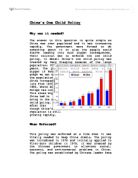
China's one child policy
China's One Child Policy Why was it needed? The answer to this question is quite simple as China was over populated and it was increasing rapidly. The government were forced to do something about it or else the people would starve leading into much bigger consequences. Their solution was to enforce the one child policy. In detail China's one child policy was created by Deng Xiaoping because of the large population; 300 million people were born over 20 years. The population would have been a lot bigger if female babies were wanted. From this graph we can see that the population in China increased lots from 1950 to 995, where as Europe has not. This shows why China had to bring in the one child policy. Even after that though China's Population is still growing rapidly. When Enforced? This policy was enforced at a time when it was vitally needed to keep China stable. The policy was introduced in 1978 and initially applied to first-born children in 1979. It was created by the Chinese government to alleviate social, economic, and environmental problems in China. The policy was established by Chinese leader Deng Xiaoping, three years after Mao's death. It was introduced around the same time as the Deng economic reforms. These reforms created a demand for more children to supply workers to increase food production and make more profit. The rationale for the