
Find out the geological appearance, structure and composition at Peacehaven, Newhaven and Rottingdean.
Index Page 1: Cover page Page 2: Index And Introduction Page 3: Peacehaven profile Page 4: Newhaven West profile Page 5: Newhaven East profile Page 6: Rottingdean profile Page 7: Explanation to Peacehaven profile Page 8: Explanation to Newhaven West and East and Rottingdean profiles Page 9: Data and Calculations and explaining the problem of using an average figure Page 10: Graph representing data collected Page 11: Problems of cliff retreat + solutions Page 12: More solutions Page 13: More solutions + Different views on the solutions Introduction In this coursework we hope to achieve many aims and we will accomplish these by visiting cliffs at Peacehaven, East Newhaven, West Newhaven and Rottingdean. Our aims are to find out the appearance, structure and composition at Peacehaven, Newhaven and Rottingdean. What the wave processes and types evident at each site are. How wave processes and cliff characteristics affect the appearance of the cliffs. What effects the physical processes on these cliff lines had on the people in the locality and what the likely consequences are and what steps could be taken to reduce the erosion hazard in these areas and what the cost and benefits are for local communities. Explanation Of Profile 1, Peacehaven Here there are many joints, faults and lines of weakness and on these faults there are many flint modules much like all

Describe and explain how the processes operating in permafrost result in landforms specific to periglacial areas.
Describe and explain how the processes operating in permafrost result in landforms specific to periglacial areas. Periglacial areas are found on the edge of glaciers and are characterised by permafrost, freeze thaw action. Summer temperatures rise above freezing point so ice melts. Three types of periglacial regions can be identified these include the Arctic continental, Alpine and Arctic maritime. Periglacial landforms and processes can be classified into five classes, Ground ice, Frost weathering, snow, meltwater and wind. Ground ice involves three processes including ice crystals and lenses (frost heave), ground contractions and freezing of ground water from these processes sorted stone polygons, ice wedges with unsorted polygons and pingos are formed. Frost heave includes several processes, which cause either fine-grained soils such as silt and clays to form small domes or individual stones within the soil to be moved to the surface. It results from the direct formation of ice - either as crystals or as lenses. The thermal conductivity of stone is greater than that of soil this results in the direct formation of ice, the area under a stone becomes colder then the surrounding area and ice crystals form. Further expansion by the ice widens the capillaries in the soil, allowing more moisture to rise and freeze. The crystals, or the larger ice lenses which form at a

The Holderness coastline is the fastest eroding coastline in Europe, what is the best plan of action for those living nearby.
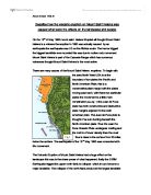
The Holderness coastline is the fastest eroding coastline in Europe. The people who live on it are worried that their houses and land may shortly fall into the sea and they want the council to protect the coastline. In some places they have built different defence systems but, what about those peoples houses and land that aren't protected, the value of their houses has fallen and no one wants to buy a house that is going to fall into the sea, they want their houses to be protected. The reason that we have conducted this investigation is to decide whether we agree with the hypothesis "The best policy along the Holderness coastline is to do nothing". The way in which we have decided to make our minds up is by visiting three different areas along the coastline. These places were Barmston, Mappleton and Withernsea. We visited Barmston first which was a long and wide beach but the only reason for this was the sea defence mechanisms in place. There were groynes placed about every half a mile down the beach, which has helped keep the sand on this particular area of the coastline. When we first got off the coast we could not really see what the problem was until we walked down the steep slop leading to the beach: We could see pipes that were once attached to houses jutting out of the side of the cliffs. Plus behind the groyne further along the beach the strip of sand

My Personal Experience - My personal experience is about my holiday to Gran Canaria, which is one of the Canry Islands.
My Personal Experience My personal experience is about my holiday to Gran Canaria, which is one of the Canry Islands. I went on the 17th of June 2002, and returned on the 24th. I went with my mum and dad. I took one of my friends with me called Pat/ and my brother and three of his friends, Mark, Scott, and John also went with us. We travelled by aeroplane and the flight seemed really long. Everybody was asleep most of the way there but I was awake the whole way either watching TV, listening to music, or thinking about the holiday. I was so exited. We finally arrived at the airport in sunny Gran Canaria and waited for our luggage to come through. We were told by a holiday rep to get on a bus that would take us to the Barbados apartments where we were staying, but when we walked out the doors there were about twenty buses sitting there. We tried asking a bus driver what bus to get on but he didn't speak English. We went back into the airport where there were a few holiday reps and they showed us where to go. The bus journey lasted for about half an hour and then we arrived at the apartments. We unloaded our luggage and then headed towards the reception which was underground. We signed in and then myself, my mum, dad, and Pat took the lift up to the third floor while my brother and his friends took another lift up to the second floor on the other side of the apartments.

How does beach sediment vary along the coast between Lochranza and Catacol?
How does beach sediment vary along the coast between Lochranza and Catacol? Hypothesis For my investigation we studied a 550m stretch of beach between Lochranza and Catacol on the Isle of Arran, as shown on the OS map (page 2). On this beach it consisted of many granite and phylite pebbles. Phylite could have ended up here from erosion from the cliffs by abrasion. The granite however is not located in this area of the island and could only be transported by the River Eason, joining the River Charmadale and also the River Catacol. I think more likely though that the granite, which ended up on the beach we are studying, came from the River Catacol. When the granite is deposited at the river mouth they are all different sizes and we say that they are 'unsorted'. This granite could have been transported round to the location where we studied by Longshore Drift travelling from the Southwest and transporting sediment along the coast towards the Northeast sorting the granite as it moved. There is evidence that longshore drift is acting and travelling from the Southwest direction. (1) It could have produced the spit located in Lochranza Bay and (2) the most dominant prevailing winds travel from that direction. For my investigation I am going to use Longshore Drift to produce 2 hypotheses: > Granite pebbles will become smaller in size towards Lochranza. > Granite pebbles will

Describe the global distribution of earthquakes.
Describe the global distribution of earthquakes According to plate tectonics, the global distribution of epicentres is related to boundaries between lithospheric plates. Earthquakes at plate boundaries are called interplate earthquakes. Less commonly, earthquakes also take place in plate interiors and these are called intraplate earthquakes. The most active region in the world corresponds to the margins of the Pacific Ocean. Earthquakes with large magnitudes take place along this zone in the Americas from the Aleutian Islands to southern Chile and from the Kamchatka peninsula in Asia to New Zealand. Besides shallow earthquakes, throughout most of this long region, intermediate and deep shocks take place along the margin of Central and South America and on the other side of the Pacific along the systems of island arcs (Aleutians, the Kuriles, Japan the Philippines) Another large seismically active region is known as the Mediterranean-Alpine-Himalayas region and extends from West to East from the Azores to the eastern coast of Asia. This region is related to the boundary between the plates of Eurasia to the North and Africa, Arabia, and India--Australia to the South. Its seismicity involves shallow, intermediate, and deep earthquakes. A third seismic region is formed by earthquakes located on ocean ridges that form the boundaries of oceanic plates, such as the Mid-Atlantic

The characteristics of the Horsbere Brook vary along it length.
The characteristics of the Horsbere Brook vary along it length. Introduction We followed the Horsbere Brook from its source in Buckholt Woods) to its confluence with the River Severn. We went to six places. They are Birdlip, Brockworth, Buckholt Woods, Innsworth, Hucclecote and Sandhurst. All these places are in the Cotswold Hills. The Cotswold Hills is made up of limestone, clay, chalk, sand and clays. As I work through my coursework, I will try and answer the following questions below and I will also think about them as I go along my coursework. ) Does the depth of the River change from source to confluence? 2) Does the width of the River change from source to confluence? 3) Does the velocity of the River change from source to confluence? 4) Does the bedload of the River become smaller in size from the source to confluence? Picture of Meander: (Meander spotted at site ) Meander - When rivers flow over a flatter land, they develop large bends called meanders. As a river goes around a bend most of the water is pushed towards the outside causing increased erosion. Attrition - Material is moved along the bed of a river, it collides with other materials and breaks up into smaller pieces. Corrasion - Fine material rubs against the river bank. The bank is worn away by a sand-papering action called abrasion and collapses. Hydraulic action - The sheer force of the

To what extent is the human response to hazards affected by variations in the economic resources available
To what extent is the human response to hazards affected by variations in the economic resources available Introduction Every year, hundreds of thousands of people are affected by natural hazards. Hazards can affect anyone at any time and there is usually little that can be done about them. But these hazards affect people who live in different economically structured communities and can affect people on different scales. The majority of people who are affected by hazards are those in poorer communities and in LEDCs. A community is defined "as the people who live in a particular place or region and usually are linked by some common interests". Within a country or area there are many communities which share a belief, live in the same area, or suffer from the effect of a disease or poverty, the different number of communities is endless. Some communities are more economically funded so that if a hazard was to occur they would either be prepared or be able to deal with the consequences. Economic resources can include a range of different things such as hazard prediction quality, emergency services, readiness for disasters, and money to rebuild after a disaster. The human response is the process that humans carry out to deal with a disaster and the awareness that a community has of the probability of a disaster occurring. Every hazard has a different scale dependent on the type
Describe how the volcanic eruption on Mount Saint Helens was caused. What were the effects on the landscape and people
Describe how the volcanic eruption on Mount Saint Helens was caused what were the effects on the landscape and people On the 18th of May 1980 mount saint. Helens Erupted all thought Mount Saint Helens is a volcano the eruption in 1980 was actually caused by an earthquake the earthquake was 5.0 on the Richter scale. The tremor trigged the biggest landslide ever recorded this was due to molten rock movement. Mount Saint Helens is part of the Cascade Range which has numerous volcanoes thought Mount Saint Helens is the most active. There are many causes of the Mount Saint Helens eruptions. To begin with the area North West USA is at the boundary of two plates the Pacific and North American Plate, this is a conservative plate margin with the plates moving past each, with these two particular plates the movement is a little more complicated (see fig .1) the Juan de Fuca plate has both constructive and destructive plate margins adjacent to the north American plate. The Juan de Fuca plate is thought of as sub ducting beneath the North American plate. Thus the Juan De Fuca Oceanic Plate undergoes melting and the melt is of lower density than the crust thus is rises to the surface from 60 miles below the surface. The earthquake of the 18th May 1980 was connected with this movement The Volcanic Eruption of Mount Saint Helens had a huge effect on the landscape this was to the sheer
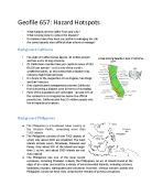
California and the Phillippines - Hazard Hotspots and Human Management of Risks
Transfer-Encoding: chunked Geofile 657: Hazard Hotspots * What hazards do they suffer from and why? * What is being done to reduce the impacts? * On balance have they been successful in managing the risk * Are some hazards more difficult than others to manage? Background California * The state of California has approx. 40 million people and has a very strong economy. * 25 Californian counties have per capita incomes of US$ 65,000 per annum – so it is one of the world’s wealthiest places, so this means that a disaster may comprise high financial losses. * It is home to the megacities of Los Angeles, San Diego and San Francisco. * Only sophisticated management prevents California from becoming a disaster zone (in terms of mortality). * Parts of the population are vulnerable - around 20% of the residents in Los Angeles live below the official poverty line. California also has 3.5 million people who live in hazardous locations. Background Philippines * The Philippines is a Southeast Asian country in the Western Pacific, comprising more than 7,000 islands. * The Philippines consists of over 7000 islands, of which only about 2000 are inhabited. The main islands include Luzon, Mindanao, Palawan and Panay. Only about 500 of the islands are larger than 1 sq km, and about 2500 islands are not even named. * The Philippines has one of the most recent volcanoes,


