THE BEACH
THE BEACH The dark night sky started to fade away as the sun started to rise on the far horizon. People woke up and got ready to go to the beach for family enjoyment. The sun making slow progress moved overhead as people rushed to the beach for a warm cosy afternoon. Old couples wearing woolly clothes and seeing the life go by. One of these couples named Jack and Doris sat watching people playing football, making sandcastles and all sorts of other activities which took them into their own nostalgic memories of when they were kids and when they used to do all these exercises but now it's too hard for them to take part. Nearby some children trying to show-off their spectacular skills in football near the sea, kicking it round while some jumped in the water enjoying the big splashes. Bikini clad-girls flirted with any good-looking talent, who passed by, getting no positive response as boys pretended to look distracted. Nearby, some girls ran straight into the water only to find that it was freezing, which caused them to squeal and they rushed back out passing several families on the beach. Young children were being forced to put on sun-cream [which annoyed them a lot but they didn't have a choice] before they could go around doing different activities like donkey riding, playing football, jumping in the water, swimming, canoeing and attending the stalls for mini-games. People
Measuring the Intensity of Earthquakes.
General An earthquake is a shaking or trembling of the crust of the earth caused by underground volcanic action or by the breaking and shifting of rock beneath the surface. The volcanic action and shifting rocks create strain which continues to build to a sudden release of pressure resulting in a shock wave. The vibrations produced in the crust can vary from barely noticeable to enormously destructive. Shock waves can be classified into two broad categories. Waves that send particles oscillating back and forth in the same direction as the waves are traveling are called primary. Primary waves, sometimes called compressional waves, travel through the earth beneath the crust. Secondary waves cause vibrations which move perpendicular to the wave. These waves travel on the surface of the earth and move much slower than primary waves. Thus, when an earthquake occurs, seismic centers throughout the world record primary waves before the secondary waves arrive. Historical Overview Earthquakes have captured the imagination of people living in earthquake prone regions since ancient times. Ancient Greek philosophers thought quakes were caused by subterranean winds, while others blamed them on fires in the bowels of the earth. About AD 130, a Chinese scholar named Chang Heng reasoned that waves must ripple through the earth from the source of an earthquake. By 1859, an Irish engineer
Measuring the Intensity of Earthquakes.
Geography Earthquakes coursework by Neil General An earthquake is a shaking or trembling of the crust of the earth caused by underground volcanic action or by the breaking and shifting of rock beneath the surface. The volcanic action and shifting rocks create strain which continues to build to a sudden release of pressure resulting in a shock wave. The vibrations produced in the crust can vary from barely noticeable to enormously destructive. Shock waves can be classified into two broad categories. Waves that send particles oscillating back and forth in the same direction as the waves are traveling are called primary. Primary waves, sometimes called compressional waves, travel through the earth beneath the crust. Secondary waves cause vibrations which move perpendicular to the wave. These waves travel on the surface of the earth and move much slower than primary waves. Thus, when an earthquake occurs, seismic centers throughout the world record primary waves before the secondary waves arrive. Historical Overview Earthquakes have captured the imagination of people living in earthquake prone regions since ancient times. Ancient Greek philosophers thought quakes were caused by subterranean winds, while others blamed them on fires in the bowels of the earth. About AD 130, a Chinese scholar named Chang Heng reasoned that waves must ripple through the earth from the source of an
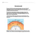
Plate tectonics
Plate tectonics model The theory of which has revolutionized modern geology. A vast amount of scientific evidence supports the central theme of the theory that the earth's outer rock layer (lithosphere) is fractured into large pieces (plates) which move around the globe, carrying overlying oceans and continents with them. The theory has correctly predicted the distribution of earthquakes, volcanoes and mountain chains, greatly improving our understanding of geology. However, not all aspects of the theory are fully explained - the driving force behind plate motion is the subject of several competing hypotheses: . The Convection Cell Model: large convection cells in the earth's partially molten mantle exert a drag on the overlying plates, carrying them along like objects on a giant conveyor belt. Ridge push" and "slab pull" are both ways that gravity can act to keep a plate in motion. Note that arrows on convection cells and overlying plate are going in the same direction. 2. The Push-Pull Model: the creation of new oceanic plate at spreading centers pushes the plates away on either side and, at the same time, colder, denser plate material sinks at subduction zones pulling the plates along behind them. The electromagnetic field applies both pushes and pulls to bodies in the field. This is accomplished via photons and photon "holes" in the field traveling both forward and
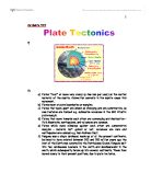
Plate Tectonics
Jai Mehta 11AY ) 2) a) Plates "float" or move very slowly (a few mm per year) on the molten material of the mantle. Convection currents in the mantle cause this movement. b) Plates meet at plate boundaries or margins. c) Plates that move apart are known as diverging and are constructive, as new features are formed e.g. submarine volcanoes in the Mid Atlantic plate margin. d) Plates that move towards each other are converging and destructive - Fold Mountains, earthquakes, and volcanoes are common. e) Plates which move sideways against each other are conservative margins - material isn't gained or lost, volcanoes are rare and earthquakes are common e.g. San Andreas Fault. f) Pangaea was a single landmass; made up of all the present continents, believed to have existed between 300 and 200 million years ago the rest of the Earth was covered by the Panthalassa Ocean. Pangaea split into two landmasses Laurasia in the north and Gondwanaland in the south, which subsequently broke up into several continents. These then moved slowly to their present positions, due to plate tectonics. Jai Mehta 11AY 3) A Map Showing The Location Of The Worlds Plate Boundaries. Jai Mehta 11AY 4) Volcanoes can be found where Earthquakes are found, at plate margins/ boundaries. The map below shows a good example of this; you can see where the pacific plate meets surrounding plates and many

Three Gorges Dam
Dam the Three Gorges The Three Gorges are known to be a famous tourist attraction for its beautiful scenery, located in northeastern China along the Yangzi River. The Yangzi River runs 3700 miles long, being the third longest river in the world after the Nile and Amazon Rivers. The Qutang Gorge, the Wuxia Gorge, and the Xiling Gorge are the three Yangzi River gorges that make up the Three Gorges. The Three Gorges are not only famous for its scenery, but also its disastrous flooding. Within a century, five major floods have occurred killing over 300,000 people living in cities along the bank of the river. This is due to the constant sediment deposits along the river, causing the river bed to continuously rise six metres to seventeen metres higher than the plains. In 1992, the Chinese National People's Congress approved the project of constructing a dam at the upper and middle reaches of the Yangzi River by the Xiling Gorge. The purpose was to adjust the water flow of the Yangzi River in hope to prevent more serious flooding. The dam is expected to be the largest hydroelectric project in the world, being 185 metres (606 feet) high and 1,983 metres (6500 feet) broad, with a reservoir that will fill a level of 175 metres above sea level.1 The 17-year construction of the dam is estimated to use 10.8 million tons of cement, 1.9 million tons of rolled steel, and 1.6 tons of

Walton on the Naze
Walton on the Naze a) Describe and explain the natural processes operating on the Naze cliffs. All along the exposed side of the Naze cliffs, and to a smaller extent on the managed areas, erosion is constantly taking place. These are as such: Slumping The Naze cliffs are made up in layers. The base off the cliffs is a thick layer of very soft but impermeable London clay. Sitting on top of this are two permeable layers. The first is the Red Crag. This is made of reddish coloured sand and shells, which are the remains of an ancient seabed from 3 million years ago. The next thinner layer is of Glacial Materials, deposited from the last ice age. Slumping occurs when it has been raining heavily. The top two permeable layers become totally saturated with water and become very heavy. The water then seeps down and reaches the impermeable London clay. Now as it cannot seep through this layer it runs out of the cliff at the intersection between the layers. This causes mini streams and fountains to be seen on the cliff. This and the weight of the material on top causes it to slip off the clay onto the beach, where the loose material is quickly taken away by normal coastal deposition. Examples of this can be seen all along the unmanaged section of the Naze. Hydrostatic pressure (Hydraulic action) Waves breaking onto the face of cliffs can exert large amounts of pressure. This has a
Why do LEDC's Suffer Greater Damage From Earthquakes Than MEDC's
Why do LEDC's Suffer Greater Damage From Earthquakes Than MEDC's A MEDC is a more economically developed country; therefore it can afford to spend money on improving the countries stability and helping to decrease the damage from an earthquake. An example of a MEDC is Kobe, in Tokyo, where in January 1995; an earthquake that measured 7.5 on the Richter scale hit the city. A LEDC is a less economically developed country and therefore cannot afford to spend money to protect the country from earthquakes. An example of an LEDC is Armenia, in Columbia, where on the 25th January 1999; an earthquake measuring 6.3 on the Richter scale was the worst earthquake the country had experienced since 1983. As MEDC's have more money to spend on prediction methods, I would expect there to be less deaths and damage in MEDC's than in LEDC's. This is due to a number of reasons. Firstly, because MEDC's are more economically developed, they can afford to spend money on prediction methods, such as GPS satellite, which is when data is sent from satellites to computers with information such as plate movement and changes in the earth's surface. This prediction method is very accurate; however, a disadvantage is that if the computers fail then all of the data will be lost. Also, the fact that MEDC's have more money would also mean that they can spend more money on preparing the country for an

Why did so many people die in the Kobe earthquake?
Why did so many people die in the Kobe earthquake? On the 15th of January 1995 at 5.46am a horrendous earthquake reaching 7.2 on the Richter scale, the worst in half a century struck the large Industrial town of Kobe. Over 5000 people were killed as a result of this earthquake. The tension built up between the Pacific and Eurasian plates and caused the earthquake, as the focus was at such a shallow point, the waves of the earthquake were very powerful. The epicenter was on Awaji Island within 20km of Kobe, so there wasn't enough space between the epicenter and Kobe for the waves to be absorbed. The earthquake first made the ground shake vertically then sideways. Hundreds of shock waves after the earthquake caused most tall buildings to collapse. As one aftershock got to the top of a building then bounced down again it would be hit by another aftershock working its way up the building, making the middle of it collapse. Houses collapsed trapping many people in their beds, immediately fires started and burnt out of control, trains were thrown off their tracks, water and gas mains collapsed. It was announced a state of emergency and army troops were sent to help. Very few people died due to the actual earthquake, most people died because of the primary or secondary effects. Primary effects such as damaged buildings or broken water or gas pipes lead to the secondary effects,


